 W
WBarelas is an inner-city neighborhood of Albuquerque, New Mexico, located immediately south of Downtown. It consists of the triangular area bounded by Coal Avenue, the BNSF railroad tracks, and the Rio Grande. Originally a separate village, it was absorbed into Albuquerque during the railroad-fueled growth of the 1880s but still retains a distinct identity. The settlement was formally established in 1662, predating even Old Town as the oldest neighborhood in the city. Although it was long one of Albuquerque's most economically distressed areas, Barelas has seen significant development since the opening of the National Hispanic Cultural Center in 2000 and may be starting to experience gentrification.
 W
WBlack Volcano is an inactive volcano located near Albuquerque, New Mexico, and is part of the Albuquerque volcanic field. Black Volcano is located directly north of JA volcano. Black Volcano is the second of five volcanoes within the western boundary of Petroglyph National Monument. North of Black Volcano are Vulcan, Bond and Butte volcanoes. The date of its last eruption is unknown, but is believed to have been more than 150,000 years ago.
 W
WDowntown Albuquerque is the central business district of Albuquerque, New Mexico. It is where a significant number of the city's highrise buildings are located, and is the center of government and business for the Greater Albuquerque metropolitan region.
 W
WHigh Desert is a master-planned community built by High Desert Investment Corporation in the Far Northeast Heights of Albuquerque, New Mexico. The boundaries of the High Desert neighborhood are Tramway Blvd. to the west, Simms Park Road to the north, the Sandia Mountains to the east, and Bear Canyon Open Space to the south. The High Desert area is one of the most expensive areas of Albuquerque. High Desert is also one of the most highly elevated neighborhoods in Albuquerque, as most of the neighborhood is at or above 6,000 feet in elevation. High Desert is zoned to Georgia O'Keeffe Elementary School, Eisenhower Middle School, and Eldorado High School.
 W
WHuning Highlands, also known as EDo or East Downtown, is an inner-city neighborhood in Albuquerque, New Mexico, directly east of Downtown. It is a mostly residential area known for its high concentration of Victorian and early 20th-century houses and is listed on the National Register of Historic Places as the Huning Highlands Historic District. There is also a commercial district along the main thoroughfares, Central Avenue and Broadway Boulevard. Huning Highlands was developed starting in 1880 and is named for Franz Huning, a prominent businessman at the time.
 W
WThe International District is a neighborhood in southeast Albuquerque, New Mexico. It is centered on Central Avenue, the historic alignment of U.S. Route 66, and contains the New Mexico State Fairgrounds. The community is one of the most diverse areas of the city and is home to a large number of international restaurants and grocery stores, as well as the city's "Little Saigon" Vietnamese enclave. It is also one of the poorest areas in the city and has a high crime rate. Prior to being re-branded as the International District in 2009, the neighborhood was commonly known as the "War Zone".
 W
WMartineztown-Santa Barbara is a neighborhood in central Albuquerque, New Mexico, immediately northeast of Downtown. Originating as a small farming village in the 1850s, it is one of the city's oldest neighborhoods and retains a distinct character, with winding streets, irregular lots, and adobe vernacular buildings reminiscent of other old Hispanic communities in northern New Mexico.
 W
WMesa del Sol is an uncompleted 16,000-acre (65 km2) mixed-use master planned community in Albuquerque, New Mexico.
 W
WNob Hill is a neighborhood in Albuquerque, New Mexico, consisting of a commercial district along Central Avenue and surrounding residential areas. Located just east of the University of New Mexico, the neighborhood was developed between about 1925 and 1950 and has since become a popular tourist and shopping destination. Known for its eclectic mix of mostly locally owned businesses, Nob Hill has been described as "the heart of Albuquerque's Route 66 culture and also its hippest, funkiest retail and entertainment district". The neighborhood is named after Nob Hill in San Francisco.
 W
WOld Town is the historic original town site of Albuquerque, New Mexico, for the provincial kingdom of Santa Fe de Nuevo México, established in 1706 by New Mexico governor Francisco Cuervo y Valdés. It is listed on the New Mexico State Register of Cultural Properties as the Old Albuquerque Historic District, and is protected by a special historic zoning designation by the city. The present-day district contains about ten blocks of historic adobe buildings surrounding Old Town Plaza. On the plaza's north side stands San Felipe de Neri Church, a Spanish colonial church constructed in 1793.
 W
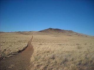
WPetroglyph National Monument stretches 17 miles (27 km) along Albuquerque, New Mexico's West Mesa, a volcanic basalt escarpment that dominates the city's western horizon. Authorized June 27, 1990, the 7,236 acre (29.28 km2) monument is cooperatively managed by the National Park Service and the City of Albuquerque. The western boundary of the monument features a chain of dormant fissure volcanoes. Beginning in the northwest corner, Butte volcano is followed to its south by Bond, Vulcan, Black and JA volcanoes.
 W
WThe Rio Grande Nature Center State Park is a New Mexico State Park located adjacent to the Rio Grande in Albuquerque, New Mexico, USA. The Rio Grande Nature Center is a 38-acre urban wildlife preserve established in 1982. About two thirds of the grounds of the Park are set aside as habitat for wildlife. The remaining acreage contains a visitors center, two gardens, several wildlife viewing areas, an education building and a building housing the non-profit Wildlife Rescue, Inc. There are four constructed ponds which provide habitat for birds and other wildlife and which mimic wetland features of the historical flood plain of the Rio Grande.
 W
WThe Rio Grande Valley State Park (RGVSP) is a park located in Albuquerque, New Mexico, established in 1983. Although officially named "State Park" this open space is actually managed by various local, state and federal agencies, as well as other organizations.
 W
WRoosevelt Park is a historic park in Albuquerque, New Mexico. It is listed on the New Mexico State Register of Cultural Properties and the National Register of Historic Places, and is a protected Albuquerque Historic Landmark. The park was built between 1933 and 1935 by manual laborers employed by President Franklin D. Roosevelt's New Deal programs, turning a sandy arroyo filled with garbage into a rolling, grassy landscape planted with over 2,000 trees and bushes. It has long been one of the city's most popular gathering and recreation areas, although it also developed a reputation as a dangerous area beginning in the 1960s. The park received a major renovation in 2006–7.
WSilver Hill is a neighborhood in southeast Albuquerque, New Mexico, which is significant as one of the oldest developments on the city's East Mesa. Much of the neighborhood is included in the Silver Hill Historic District, which was listed on the National Register of Historic Places in 1986. The neighborhood is roughly bounded by Central Avenue, Yale Boulevard, Central New Mexico Community College, and Presbyterian Hospital. The northeast corner of the neighborhood borders the University of New Mexico campus.
 W
WSouth Broadway is an inner-city neighborhood in Albuquerque, New Mexico, located southeast of Downtown. The neighborhood developed between the 1890s and early 1900s and has a housing stock consisting mainly of smaller Victorian homes and bungalows. It was historically a diverse working-class neighborhood and the center of the city's African American community.
 W
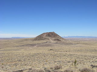
WVulcan, named after the Roman god of fire, is an inactive volcano on Albuquerque, New Mexico's West Mesa. It is the largest of the volcanoes in Albuquerque's Volcanic Field. Vulcan is a spatter cone, formed primarily by fire fountains that were active in the central vent and in smaller vents on flanks of the cone. These flank vents formed the arches and caves seen today. From a vantage point on top of the cone 600 feet above valley floor, the alignment of the 5-mile-long chain of vents is particularly noticeable. Fragmented cinder and spatter material and lava flows dip at angles as high as 55° away from the central vent on the eastern and southern side of Vulcan. The spatter material is thickest on the southeastern side of Vulcan, indicating that it was blown by the wind toward the south and east during the fountaining events. A solidified lava pond that consists of a massive gray basalt with weakly developed columnar jointing occupies the crater of Vulcan. Radial, sinuous lava tubes 8 to 20 inches across and 300 feet long are preserved on the northeast and northwest flanks of Vulcan.