 W
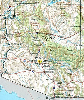
WArizona is a landlocked state situated in the southwestern region of the United States of America. It has a vast and diverse geography famous for its deep canyons, high- and low-elevation deserts, numerous natural rock formations, and volcanic mountain ranges. Arizona shares land borders with Utah to the north, the Mexican state of Sonora to the south, New Mexico to the east, and Nevada to the northwest, as well as water borders with California and the Mexican state of Baja California to the southwest along the Colorado River. Arizona is also one of the Four Corners states and is diagonally adjacent to Colorado.
 W
WThe Apache Trail in Arizona was a stagecoach trail that ran through the Superstition Mountains. It was named the Apache Trail after the Apache Indians who originally used this trail to move through the Superstition Mountains.
 W
WThe Arizona Strip is the part of Arizona lying north of the Colorado River. The difficulty of crossing the Grand Canyon causes this region to have more physical and cultural connections with southern Utah and Nevada than with the rest of Arizona. The largest settlements in the Strip are Colorado City and Fredonia.
 W
WThe Arizona Sun Corridor, shortened Sun Corridor, is a megaregion, or megapolitan area, in the southern area of the U.S. state of Arizona. The Sun Corridor is comparable to Indiana in both size and population. It is one of the fastest growing conurbations in the country and is speculated to double its population by 2040. The largest metropolitan areas are the Phoenix metropolitan area - Valley of the Sun - and the Tucson metropolitan area. The regions' populace is nestled in the valley of a desert environment. Similar to Southern California, the urban area extends into Mexico, reaching the communities of Nogales and Agua Prieta.
 W
WThe Arizona transition zone is a diagonal northwest-by-southeast region across central Arizona. The region is a transition from the higher elevation Colorado Plateau to the northeast in Northeast Arizona and the Basin and Range region of southwest and south regions of lower elevation deserts.
 W
WCopper mining in Arizona, a state of the United States, has been a major industry since the 19th century. In 2007 Arizona was the leading copper-producing state in the US, producing 750 thousand metric tons of copper, worth a record $5.54 billion. Arizona's copper production was 60% of the total for the United States. Copper mining also produces gold and silver as byproducts. Byproduct molybdenum from copper mining makes Arizona the nation's second-largest producer of that metal. Although copper mineralization was found by the earliest Spanish explorers of Arizona, the territory was remote, and copper could seldom be profitably mined and shipped. Early Spanish, Mexican, and American prospectors searched for gold and silver, and ignored copper. It was not until the completion of the Southern Pacific Railroad in 1876 that copper became broadly economic to mine and ship to market.
 W
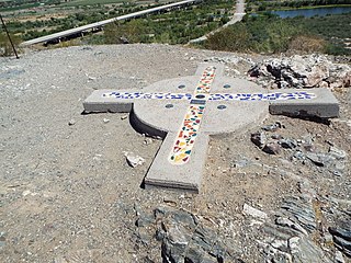
WThe Gila and Salt River Meridian intersects the initial point on the south side of the Gila River, opposite the mouth of Salt River, at latitude 33° 22′ 37.82733″ north, longitude 112° 18′ 21.99931″ west from Greenwich based on NAD 83, and governs the surveys in the territory of Arizona. The current declination for the initial point is 12° east. It is located on Monument Hill, an easily visible hill just south of the confluence of the Gila and Salt Rivers, in Avondale, Arizona, about 14 miles southwest of downtown Phoenix. The original marker was set in 1851 by John R. Bartlett. In 1934, the U.S. Coast and Geodetic Survey set triangulation station "INITIAL" approximately 15 feet from the initial point. Ty White, Associate Cadastral Engineer for the U.S. Bureau of Land Management (BLM), re-monumented the initial point on December 1, 1944. On April 24,1962, the monument was re-established by Leonard W. Murphy, based on the Ty White's field notes, because the previous monument had been vandalized. On April 26, 1984, Paul L. Reeves and John P. Bennet re-monumented the original corner. On February 19, 2006, the initial point was again re-monumented due to deterioration of the 1985 plaque. This re-monumentation was performed by staff from the BLM, members of the Arizona Professional Surveyors Society, and students at Phoenix College. The initial point was added to the National Register of Historic Places as of October 15, 2002. The plaque for that listing was installed as part of the 2006 re-monumenting.
 W
WThis is a list, which includes a photographic gallery, of some of the remaining structures and monuments, of historic significance in Avondale, a city in Maricopa County, Arizona, United States, adjacent to Phoenix, Arizona.Farming was the main industry in Avondale in the late 1890s. Avondale was incorporated in 1946.
 W
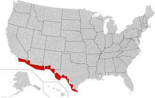
WThe Mexico–United States border is an international border separating Mexico and the United States, extending from the Pacific Ocean in the west to the Gulf of Mexico in the east. The border traverses a variety of terrains, ranging from urban areas to deserts. The Mexico–United States border is the most frequently crossed border in the world, with approximately 350 million documented crossings annually. It is the tenth-longest border between two countries in the world.
 W
WThe Navajo Section is a physiographic section of the larger Colorado Plateaus Province, which in turn is part of the larger Intermontane Plateaus physiographic Division.
 W
WNorthern Arizona is an unofficial, colloquially-defined region of the U.S. state of Arizona. Generally consisting of Apache, Coconino, Mohave, and Navajo counties, the region is geographically dominated by the Colorado Plateau, the southern border of which in Arizona is called the Mogollon Rim.
 W
WOptics Valley is a region in southern Arizona, centered on Tucson, that is home to a high concentration of optics companies spawned by research at the University of Arizona. Based on the idea of a technology cluster such as Silicon Valley, Optics Valley is known not only for its optics industry and research but also for the astronomical observatories located in the mountains of southern Arizona where clear skies and isolated peaks make for superior observing conditions.
 W
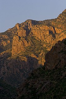
WThe Santa Catalina Ranger District governs the Santa Catalina Mountains within the Coronado National Forest, northeast of Tucson, Arizona.
 W
WSilver mining in Arizona was a powerful stimulus for exploration and prospecting in early Arizona. Cumulative silver production through 1981 totaled 490 million troy ounces. However, only about 10% of Arizona's silver production came from silver mining. More than 80% of the state's silver was a byproduct of copper mining; other silver came as a byproduct of lead, zinc, and gold mining.
 W
WSouthern Arizona is a region of the United States comprising the southernmost portion of the State of Arizona. It sometimes goes by the name Gadsden or Baja Arizona, which means "Lower Arizona" in Spanish.
 W
WThe following timeline traces the territorial evolution of the U.S. State of Arizona.
 W
WThe Valley and range sequence-Southern Yuma County is a 3-Valley sequence of NW–by–SE trending block faulted valleys and mountains. About eleven major mountain ranges connect to each other in four,, mountain sequences.