 W
WDoi Ian is a mountain in Thailand, part of the Phi Pan Nam Range, at the southeastern end of Chiang Rai Province limit near the point where the limit of this province meets with the northern end of Phayao Province, nine km from the border with Laos.
 W
WDoi Lan is a mountain in Thailand, part of the Phi Pan Nam Range, in the center of Chiang Rai Province, south of Chiang Rai Town. With a height of 559 metres Doi Lan gives its name to the Doi Lan Subdistrict of Mueang Chiang Rai District.
 W
WDoi Luang National Park is one of the biggest national parks in Northern Thailand.
 W
WDoi Mae Salong is a mountain in Thailand, part of the Daen Lao Range. It is in the northern part of Chiang Rai Province six km. from the border with Burma.
 W
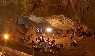
WDoi Nang Non is a mountain range in the Thai highlands in Chiang Rai Province, Thailand. It is a karstic formation with numerous waterfalls and caves rising at the southern end of the Daen Lao Range. Part of its area is managed as the Tham Luang–Khun Nam Nang Non Forest Park.
 W
WDoi Tung (ดอยตุง) is a mountain in the Thai highlands of Mae Fa Luang District, Chiang Rai Province, Thailand.
 W
WThe Ing River is a tributary of the Mekong River in the northern part of Thailand. It has its source in Doi Luang, Phi Pan Nam Range, in Mae Chai District, Phayao Province. The Ing flows through the plain area of Thoeng District.
 W
WKhun Chae National Park is a national park in Chiang Rai Province, Thailand. This rugged park is home to high mountains and waterfalls.
 W
WThe Khun Tan Range is a mountain range that occupies a central position in Northern Thailand. Most of the range is located in Chiang Mai, western Chiang Rai, Lampang and Lamphun Provinces.
 W
WThe Kok River flows in Southeast Asia.
 W
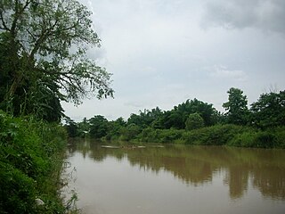
WThe Lao River or Mae Lao River is a river in Chiang Rai Province, Northern Thailand. It is a tributary of the Kok River, with its mouth near Sum Pratu in Mueang Chiang Rai District. This river gives its name to the Mae Lao District.
 W
WThe Phi Pan Nam Range, also Pee Pan Nam, is a 400 km (249 mi) long system of mountain ranges in the eastern half of the Thai highlands. It is mostly in Thailand, although a small section in the northeast is within Sainyabuli and Bokeo Provinces, Laos.
WPhu Chi Fa, also Phu Chee Fah, is a mountain area and national forest park in Thailand. It is located at the northeastern end of the Phi Pan Nam Range, 12 km to the southwest of Doi Pha Tang at the eastern edge of Thoeng District, Chiang Rai Province.
 W
WPhu Sang National Park is a national park in Northern Thailand.
 W
WThe Ruak River is a right hand tributary of the Mekong. The mouth of the Ruak river is at the Thai-Burma border opposite Laos, a spot known as the "Golden Triangle", a popular tourist destination.
 W
WTham Luang Nang Non is a karstic cave system in the Tham Luang–Khun Nam Nang Non Forest Park, near the village of Pong Pha, in northern Thailand. It lies beneath Doi Nang Non, a mountain range on the border with Myanmar.
 W
WThe Wang River is a river in northern Thailand.