 W
WCoimbatore is the second largest city in the Indian state of Tamil Nadu. It is situated in the western corner of Tamil Nadu, a short distance from the border with the neighbouring state of Kerala, and is surrounded by the Western Ghats on all sides.
 W
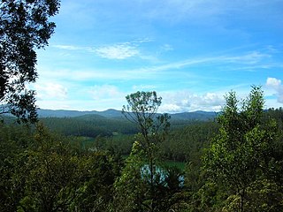
WAliyar (ஆழியாறு) (also spelt Azhiyar / Aaliyar) Reservoir is a 6.48 km2 (2.5 sq mi) reservoir located in Aliyar village near Pollachi town in Coimbatore District, Tamil Nadu, South India. The dam is located in the foothills of Valparai, in the Anaimalai Hills of the Western Ghats. It is about 65 kilometres (40 mi) from Coimbatore. The dam offers some ideal getaways including a park, garden, aquarium, play area and a mini Theme-Park maintained by Tamil Nadu Fisheries Corporation for visitors enjoyment. The scenery is beautiful, with mountains surrounding three quarters of the reservoir. Boating is also available.
 W
WThe Amaravathi Dam is a dam constructed across the Amaravathi River. It is located at Amaravathinagar, 25 kilometres (16 mi) south of Udumalpet on SH 17 in the Indira Gandhi Wildlife Sanctuary, Tirupur district in the Indian state of Tamil Nadu. The associated Amaravathi Reservoir is 9.31 square kilometres (3.59 sq mi) in area and 33.53 metres (110.0 ft) deep. The dam was built primarily for irrigation and flood control and now also has four megawatts of electrical generating capacity installed. It is notable for the significant population of mugger crocodiles living in its reservoir and catchment basin.
 W
WThe Amaravati River is the longest tributary of Kaveri River in the fertile districts of Karur and Tirupur, Tamil Nadu state, South India.
 W
WAnaimalai is a new taluk separated from Pollachi in Coimbatore district, Tamil Nadu state, India. As per Govt. of Tamil Nadu, it's declared as a new Taluk from 25 October 2018. There are around 31 Villages has been part of Anaimalai Taluk.
 W
WThe Anaimalai or Anamala Hills, also known as the Elephant Mountains, are the range of mountains that form the southern portion of the Western Ghats and span the border of Tamil Nadu and Kerala in Southern India. The name anamala is derived from the Tamil/Malayalam word anai or ana, meaning elephant, and malai or mala, meaning hill – thus Elephant Hill.
 W
WThe Chinnar River originates in the Annaimalai Hills below a grassy pass between the hills Kumarikkal Mala (8,275 ft) and Kaladekatti Malai In Idukki District, Kerala state South India. The 18 km long Chinnar river defines the East-West Tamil Nadu/Kerala state boundary along the northern edge of the Chinnar Wildlife Sanctuary and the southern edge of the Indira Gandhi Wildlife Sanctuary. Several adult Crocodiles were reported in the Chinnar river in 1992.
 W
WAanaimalai Tiger Reserve, earlier known as Indira Gandhi Wildlife Sanctuary and National Park (IGWLS&NP) and previously as Aanaimalai Wildlife Sanctuary, is a protected area located in the Anaimalai Hills of Pollachi and Valparai taluks of Coimbatore District and Udumalaipettai taluk in Tiruppur District, Tamil Nadu, India. The Tamil Nadu Environment and Forests Department by a notification dated 27 June 2007, declared an extent of 958.59 km2 that encompassed the erstwhile IGWLS&NP or Aanaimalai Wildlife Sanctuary, as Aanaimalai Tiger Reserve under the Wildlife Protection Act, 1972. According to the National Tiger Conservation Authority, the Reserve presently includes a core area of 958.59 km2 and buffer/peripheral area of 521.28 km2 forming a total area of 1479.87 km2.
 W
WManjampatti Valley is a 110.9 km2 (42.8 sq mi) protected area in the eastern end of Indira Gandhi Wildlife Sanctuary and National Park (IGWS&NP) in Tirupur District, Tamil Nadu, South India. It is a pristine drainage basin of shola and montane rain forest with high biodiversity recently threatened by illegal land clearing and cultivation.
 W
WThe Nilgiri Biosphere Reserve is an International Biosphere Reserve in the Western Ghats and Nilgiri Hills ranges of South India. The Nilgiri Sub-Cluster is a part of the Western Ghats, which was declared a World Heritage Site by UNESCO in 2012. It includes the Aralam, Mudumalai, Mukurthi, Nagarhole, Bandipur and Silent Valley national parks, as well as the Wayanad, Karimpuzha, and Sathyamangalam wildlife sanctuaries.
 W
WThe Nilgiri Mountains form part of the Western Ghats in western Tamil Nadu, India. At least 24 of the Nilgiri Mountains' peaks are above 2,000 metres (6,600 ft), the highest peak being Doddabetta, at 2,637 metres (8,652 ft).
 W
WThe Noyyal River is a small river in Western Tamil Nadu, and a tributary of Kaveri River. It rises from the Vellingiri hills in the Western Ghats in Tamil Nadu, very close to Kerala border, and flows through many villages and the cities of Coimbatore, and Tirupur finally draining into the Kaveri River at Noyyal, a village in Karur district named after the river itself. The river's basin is 180 km (110 mi) long and 25 km (16 mi) wide and covers a total area of 3,500 km2 (1,400 sq mi). Cultivated land in the basin amounts to 1,800 km2 (690 sq mi) while the population density is 120 people per km² (311/mi²) in the countryside, and 1000 people per km² (2590/mi²) in the cities. The area is known for its scanty rainfall and the development of the Noyyal River Tanks System to hold any overflow from the rains plus the water of the Northeast and Southwest monsoon season was ecologically important. The 173 km (107 mi) long tributary of the Kaveri River filled 32 tanks. These interconnecting tanks held the water flowing from the Noyyal.
 W
WSengupathi Falls are situated 35 km (22 mi) from Coimbatore city on the Coimbatore - Siruvani Road.
 W
WThe Siruvani big River is a river near Coimbatore, India. It is tributary of Bhavani river, which in turn is a tributary of Kaveri. Part of the Siruvani River is near Mannarkkad in the Indian District of Palakkad, Kerala. The river leads into two big tourist attractions in Southern India, namely, the Siruvani Dam and the Siruvani Waterfalls. The dam is also near The Banan Fort. Banan Fort and the Siruvani Dam, are 15 to 25 kilometres west of Coimbatore city. The river has a village named after it, or possibly vice versa.
 W
WThe Velliangiri Mountains, a part of the Nilgiri Biosphere Reserve, are situated at the Western Ghats border of Coimbatore district, Tamil Nadu bordering Palakkad District, Kerala. Known as the "Sapthagiri, 7 Hills - Seven Mountains", these mountains are held and revered on par with spiritually most powerful place on the planet - Mount Kailash, the legendary abode of Lord Shiva. On the top of the Velliangiri Mountains, Shiva is worshipped as Swayambhu, one who is self-created and in this form, he graces the devotees.
 W
WWalayar is a border town, located in the Palakkad district of Kerala, India. The Kerala-Tamil Nadu border check post is situated here, and is marked by an arch. It is 26 km from Palakkad on the NH 544, 27km from the Coimbatore Railway station and 37km from the Coimbatore International Airport.
 W
WThe Western Ghats, also the "Sahyadri", is a mountain range that covers an area of 160,000 square kilometres (62,000 sq mi) in a stretch of 1,600 kilometres (990 mi) parallel to the western coast of the Indian peninsula, traversing the states of Tamil Nadu, Kerala, Karnataka, Goa, Maharashtra and Gujarat. It is a UNESCO World Heritage Site and is one of the eight hot-spots of biological diversity in the world. It is sometimes called the Great Escarpment of India. It contains a very large proportion of the country's flora and fauna, many of which are only found in India and nowhere else in the world. According to UNESCO, the Western Ghats are older than the Himalayas. They influence Indian monsoon weather patterns by intercepting the rain-laden monsoon winds that sweep in from the south-west during late summer. The range runs north to south along the western edge of the Deccan Plateau, and separates the plateau from a narrow coastal plain, called Konkan, along the Arabian Sea. A total of thirty-nine areas in the Western Ghats, including national parks, wildlife sanctuaries and reserve forests, were designated as world heritage sites in 2012 – twenty in Kerala, ten in Karnataka, six in Tamil Nadu and four in Maharashtra.