 W
WHawaiʻi is the largest island located in the U.S. state of Hawaii. It is the largest and the southeasternmost of the Hawaiian Islands, a chain of volcanic islands in the North Pacific Ocean. With an area of 4,028 square miles (10,430 km2), it has 63% of the Hawaiian archipelago's combined landmass, and is the largest island in the United States. However, it has only 13% of Hawaiʻi's people. The island of Hawaiʻi is the third largest island in Polynesia, behind the two main islands of New Zealand.
 W
WThe 1868 Hawaii earthquake was the largest recorded in the history of Hawaiʻi island, with an estimated magnitude of 7.9 Mfa and a maximum Mercalli intensity of X (Extreme). The earthquake occurred at 4 p.m. local time on April 2, 1868 and caused a landslide and tsunami that led to 77 deaths. The aftershock sequence for this event has continued up to the present day.
WThe 1975 Hawaii earthquake occurred on November 29 with a moment magnitude of 7.4 and a maximum Mercalli intensity of VIII (Severe). The shock affected several of the Hawaiian Islands and resulted in the deaths of two people and up to 28 injured. Significant damage occurred in the southern part of the Big Island totaling $4–4.1 million and it also triggered a small brief eruption of Kilauea volcano.
 W
WHāmākua is a district on the northeast coast of Hawaiʻi's Big Island, administered by the County of Hawaiʻi in the state of Hawaiʻi. It is also the name given for the coastline in the region, the "Hāmākua Coast".
 W
WHilo is a moku or district on the Big Island of Hawaiʻi in the State of Hawaii, U.S.A. In the current system of administration of Hawaiʻi County, the moku of Hilo is divided into North Hilo District and South Hilo District.
 W
WThe ʻĀinapō Trail was the primary route to the summit of Mauna Loa from prehistory to 1916. The trail began on the southeast flank at 2000 feet of elevation and reached Mokuaweoweo, the summit crater, at 13,200 feet (4,000 m). It was sometimes called Menzies Trail after Archibald Menzies who was the first recorded outsider to climb the mountain in 1794. The Ainapo Trail was added to the National Register of Historic Places on August 30, 1974.
 W
WThe Kaʻū Desert is a leeward desert in the district of Kaʻū, the southernmost district on the Big Island of Hawaii, and is made up mostly of dried lava remnants, volcanic ash, sand and gravel. The desert covers an area of the Kīlauea Volcano along the Southwest rift zone. The area lacks any vegetation, mainly due to acid rainfall.
 W
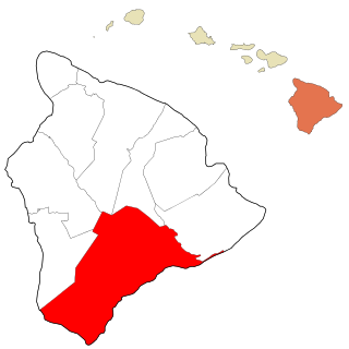
WKaʻū is the southernmost district of Hawaii County, Hawaii, located on the island of Hawaiʻi.
 W
WKaʻūpūlehu is the site of a historic settlement on the west coast of Hawaiʻi island, the largest of the Hawaiian Islands. Devastated by a lava flow, the area is now the home of luxury hotels such as the Four Seasons Resort Hualalai.
 W
WKāneaka Hōlua Slide which is better known today as the Keauhou Hōlua Slide is located in Keauhou on the island of Hawaiʻi. It is the largest remaining hōlua course left in the islands, which needs to be better maintained and preserved as a usable hōlua course. This particular kahua hōlua was used in the extremely dangerous activity of sliding across solidified lava surface. Though many had believed for years that this ritualistic practice was restricted to the aliʻi class of men, this is not the case. The majority of oral and written histories of heʻehōlua prior to missionary/western influence was inclusive of the female as well as the male nobility of ancient Hawaii. Contrary to popular belief, heʻehōlua was widely practiced among all the Kanaka Maoli community throughout the paeʻāina (Kingdom). This particular hōlua course was primarily used for ritualistic purposes, but perhaps there were times when it was openly used. There are several burials found throughout the slide area suggesting that injuries and death were common when sliding down this particular course. The remaining length of the slide is approx. 2,600 feet (790 m) long, of the original length which was said to be over 5,280 feet (1,600 m) long. The slide course ended on the shoreline at Heʻeia Bay. Small portions of the hōlua course are still remain on the shoreline at the end of the hōlua slide where the waves meet the rock coastline. When constructed it was first layered with large slabs of pāhoehoe lava with smaller and smaller lava material added until the kahua hōlua was finished off with a fine ash surface to cover those larger pieces of lava rock. When in use, it was covered lightly with pili grass to provide a medium surface to minimize the friction between the papahōlua and lava rock surface during the practice of heʻehōlua. Today, there is one usable kahua hōlua slide that was constructed in 2011 and is located at Turtle Bay Resort, Kahuku, Oʻahu. Other than that heʻehōlua is practiced today in pastures on the high slopes of Hawaiʻi Island and Maui, as well as on groomed grass hills throughout Hawaiʻi.
 W
WKīholo Bay is located in the ahupua`a of Pu`u Wa`awa`a in the North Kona District on the Big Island of Hawaii. the land surrounding the bay is flanked to the South by a lava flow from Mount Hualalai ca. 1801 and another flow from Mauna Loa in 1859. The land surrounding Kīholo Bay is under the authority of Hawai‘i State Parks. Approximately 2 miles long (3.2 km), it is one of the island's largest bays. Kīholo Bay is now a popular site for tourists and nature enthusiasts.
 W
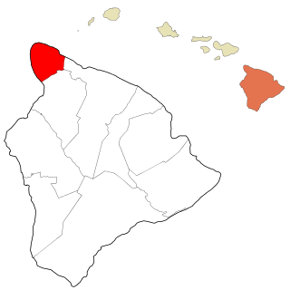
WKohala is the name of the northwest portion of the island of Hawaiʻi in the Hawaiian Archipelago. In ancient Hawaii it was often ruled by an independent High Chief called the Aliʻi Nui. In modern times it is divided into two districts of Hawaii County: North Kohala and South Kohala. Locals commonly use the name Kohala to refer to the census-designated places of Halaʻula, Hāwī, and Kapaʻau collectively. The dry western shore is commonly known as the Kohala Coast, which has golf courses and seaside resorts.
 W
WKona is a moku or district on the Big Island of Hawaiʻi in the State of Hawaii, known for its Kona coffee and the location of the Ironman World Championship Triathlon. In the current system of administration of Hawaiʻi County, the moku of Kona is divided into North Kona District and South Kona District. The term "Kona" is sometimes used to refer to its largest town, Kailua-Kona. Other towns in Kona include Kealakekua, Keauhou, Holualoa, Hōnaunau and Honalo.
 W
WMāhukona is a former settlement on the island of Hawaiʻi. The extinct submerged volcano Māhukona, off shore and to the south, is named for this area. The settlement was once the terminus of the Hawaiian Railroad.
 W
WPua'a-2 Agricultural Fields Archeological District is a historic site of Ancient Hawaii agriculture on the Big Island of Hawaiʻi.
 W
WPuna is one of the 9 districts of Hawaii County on the Island of Hawaiʻi. It is located on the windward side of the island and shares borders with South Hilo district in the north and Kaʻū district in the west. With a size of just under 320,000 acres (1,300 km2) or 500 sq. miles. Puna is slightly smaller than the island of Kauaʻi.
 W
WWaiākea-Uka (IPA:/'waj.ə.kei.ə.'u.kə/) is an ancient subdivision (ahupuaʻa) in the Hilo District of the Big Island of Hawaiʻi, located mauka (mountain-side) of the Waiākea ahupua'a; its location is on the lower flanks of the volcano Mauna Loa. Because of this, one meaning of the name 'Waiākea-Uka' can be translated from 'Olelo Hawai'i as '(the) mountain-side (of) Waiākea'. Many ahupua'a have this -uka appellation, as the directions 'mountain-side' and 'sea-side' (makai) are the two best ways of orientating something in space on any of the islands.