 W
WCayambe or Volcán Cayambe is a volcano in Ecuador, in the Cordillera Central, a range of the Ecuadorian Andes. It is located in Pichincha Province, some 70 km (43 mi) northeast of Quito. It is the third-highest mountain in Ecuador, at an elevation of 5,790 m (18,996 ft) above sea level.
WCayambe Coca National Park is a national park in Ecuador located along the Equator about 38 km (24 mi) from Quito. The park encompasses an area of 4,031.03 km2.
 W
WCotopaxi National Park is a protected area in Ecuador situated in the Cotopaxi Province, Napo Province and Pichincha Province, roughly 50 km (31 mi) south of Quito. The Cotopaxi volcano that lends its name to the park is located within its boundaries, together with two others: the dormant Rumiñawi volcano to its north-west and the historical Sincholagua volcano to the south east. Cotopaxi is among the highest active volcanoes in the world; its last significant eruption took place in 1904.
 W
WThe Cangahua Formation is a Late Pleistocene geologic formation of the Pichincha Province in north-central Ecuador.
 W
WIllinizas Ecological Reserve is a protected area in Ecuador, located in the provinces of Cotopaxi and Pichincha. The reserve consists of 149,900 hectares, and lies 55 kilometers south of Quito.
 W
WMaquipucuna is a 6,000 hectare cloud forest reserve in Ecuador. Located in the Pichincha Province, it is the closest pristine rainforest to Quito, Ecuador's capital. The reserve consists of primary and secondary montane rain forest and cloud forest. The Maquipucuna Reserve is located in the parish of Nanegal, within the Metropolitan District of Quito.
 W
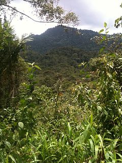
WMindo is a mountainous watershed in the western slopes of the Andes, where two of the most biologically diverse ecoregions in the world meet: the Chocoan lowlands and the Tropical Andes. In this transitional area — which covers an area of 268 square kilometers (103 sq mi) and ranges from 960–3,440 metres (3,150–11,290 ft) above sea level — three rivers and hundreds of streams irrigate the landscape, which is a patchwork of cloud forests, secondary forests, agricultural land, and human settlements.
 W
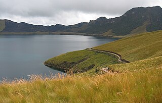
WMojanda is an inactive stratovolcano of the Eastern Cordillera of the Andes in northern Ecuador. A summit caldera, which was produced by an explosive Plinian Eruption that marked the end of Mojanda activity 200,000 years ago, is occupied by three crater lakes: Karikucha, Yanakucha, and Warmikucha. Having received protected status in 2002, they are a popular tourist destination and are about 20 minutes taxi ride from the largely indigenous town of Otavalo.
WPambamarca is an eroded stratovolcano in the Central Cordillera of the northern Ecuadorian Andes in Pichincha Province. it is 25 miles (40 km) northeast of Quito. The summit is at an elevation of 4,062 metres (13,327 ft).
 W
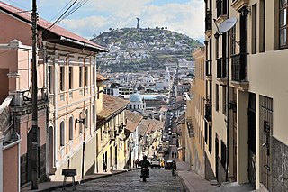
WEl Panecillo is a 200-metre-high hill of volcanic-origin, with loess soil, located between southern and central Quito. Its peak is at an elevation of 3,016 metres (9,895ft) above sea level. The original name used by the aboriginal inhabitants of Quito was Yavirac. According to Juan de Velasco, a Jesuit historian, there was a temple on top of Yavirac where the Indians worshiped the sun until it was destroyed by the Spanish conquistadores. The street that leads up to El Panecillo is named after Melchor Aymerich.
 W
WPasochoa is an extinct volcano located in the Guayllabamba river basin in the Ecuadorian Andes. The current mountain form is a collapsed crater with a semicircular shape. This structure emerged approximately 100 thousand years ago due to an eruption which destroyed the crater and occidental slope of the previous volcanic cone.
 W
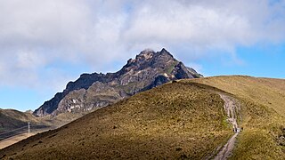
WPichincha is an active stratovolcano in the country of Ecuador. The capital Quito wraps around its eastern slopes.
 W
WPomasqui Valley is a valley on the northern outskirts of Quito, Ecuador. It is located on the equator, the so-called "Mitad del Mundo", at an altitude of around 2,600 metres (8,500 ft) above sea level. Hot and semi-arid, it is formed by a river tributary. The valley contains the Cerro de Catequilla, which contains the pre-Columbian astronomical observatory, Catequilla. The village of Pomasqui itself lies roughly 6 kilometres (3.7 mi) from the equator. The Monjas River flows nearby and the valley is an important centre for viniculture in Ecuador, with vineyards. The economy features vegetable and fruit production. To the northwest is the Pululahua Geobotanical Reserve.
 W
WPululahua is a dormant volcano in the north of Quito Canton, Pichincha Province, Ecuador. The volcano is in the Western Cordillera of the northern Ecuadorian Andes, approximately west-southwest of Mojanda and north of Casitahua volcanoes. Pululahua's caldera is approximately 5 km wide.
 W
WReserva Geobotánica Pululahua is a protected area around Pululahua Volcano in the north of Quito Canton, Pichincha Province, Ecuador. It is 17 km north of Quito, in the northwestern part of the Pomasqui Valley. This sites most notable feature is the "El cráter de Pululahua" which is one of only two volcanic craters inhabited in the world. Often, this reserve is shrouded in a thick layer of clouds or fog. The land here is extremely fertile because it is volcanic (igneous) soil and, as mentioned earlier, is used to cultivate crops. The terrain here is very rugged as for it was once a crater of a volcano.
WThe Refugio Paz de Las Aves is a 25-hectare (62-acre) private nature reserve in the western foothills of the Ecuadorian Andes. It is located near the equator at 1,969 metres' altitude, between Mindo parish and Nanegalito. Besides grassland and secondary forest, 10 ha of the area is covered by primary forest on steep inclines, that is protected by the owners.
 W
WSanta Lucia Cloud Forest is a cloud forest reserve, located about 80 km northwest of Quito, in the province of Pichincha, in Ecuador. This is at the far south of the southern phase of the Choco-Andean Rainforest Corridor. Rainforest Concern works with the Santa Lucia co-operative, a community-based conservation organisation dedicated to conservation and to sustainable development so that they can make a modest living whilst conserving their remaining cloud forest.