 W
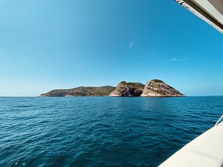
WAlcatrazes is a Brazilian archipelago, located some 35 km south of São Sebastião, in the northern coast of the State of São Paulo, one hour away by boat, approximately. It is protected by the largest marine integral conservation unit of Brazil after the Abrolhos Marine National Park.
 W
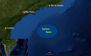
WThe Florianópolis Formation is a geological formation of the Santos Basin offshore of the Brazilian states of Rio de Janeiro, São Paulo, Paraná and Santa Catarina. The predominantly sandstone formation with interbedded shales and siltstones dates to the Early Cretaceous period; Albian epoch and has a thickness in the type oil well of 343 metres (1,125 ft).
WThe Guaratiba Group is a geological group of the Santos Basin offshore of the Brazilian states of Rio de Janeiro, São Paulo, Paraná and Santa Catarina. The group forms the pre-salt layer in the petroleum-rich basin and hosts the biggest oil fields of Brazil, as Tupi, Júpiter and many more. The group contains, depending on the definition, three to four formations and dates to the Early Cretaceous period; Hauterivian to Early Aptian epochs. The total thickness of the group, representing the first phase of sedimentation after the break-up of Gondwana in the Santos Basin, is estimated at 4,200 metres (13,800 ft).
WThe Guarujá Formation is a geological formation of the Santos Basin offshore of the Brazilian states of Rio de Janeiro, São Paulo, Paraná and Santa Catarina. The predominantly calcarenite formation with marls dates to the Early Cretaceous period; Early Albian epoch and has a maximum thickness of 2,500 metres (8,200 ft). The formation is the second-most important post-salt reservoir rock of the Santos Basin.
WThe Iguape Formation is a geological formation of the Santos Basin offshore of the Brazilian states of Rio de Janeiro, São Paulo, Paraná and Santa Catarina. The calcarenite, shale, siltstone, marl and conglomerate formation dates to the Tertiary period and has a maximum thickness of 2,200 metres (7,200 ft).
 W
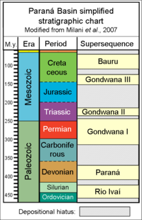
WIrati Formation is the name of a geological formation of the Paraná Basin in Brazil. It has previously been dated as Late Permian using palynomorphs, but is now dated as Early Permian using zircon ages obtained from bentonite layers. The base of the formation has been dated at 278.4 ± 2.2 Ma. Exposures of the Irati Formation are to be found in the South, southeastern Brazil and in the states of Goiás, Mato Grosso, São Paulo, Paraná, Santa Catarina, Rio Grande do Sul and Mato Grosso do Sul. The formation is part of the Passa Dios Group, underlying the Serra Alta Formation and overlying the Palermo Formation. The formation has been deposited in a restricted marine environment. The Irati Formation, with a maximum thickness of 80 metres (260 ft), was defined and named by White in 1908.
WThe Itajaí-Açu Formation is a geological formation of the Santos Basin offshore of the Brazilian states of Rio de Janeiro, São Paulo, Paraná and Santa Catarina. The predominantly shale with interbedded turbiditic sandstones formation dates to the Late Cretaceous period; Cenomanian-Maastrichtian epochs and has a maximum thickness of 2,000 metres (6,600 ft). The formation is a reservoir rock of the fields in the Santos Basin.
WThe Itanhaém Formation is a geological formation of the Santos Basin offshore of the Brazilian states of Rio de Janeiro, São Paulo, Paraná and Santa Catarina. The predominantly shale formation with marls, siltstones and sandstones dates to the Early Cretaceous period; Early Albian epoch and has a maximum thickness of 1,500 metres (4,900 ft). The formation is the reservoir rock of the Tambaú Field in the Santos Basin.
WThe Juréia Formation is a geological formation of the Santos Basin offshore of the Brazilian states of Rio de Janeiro, São Paulo, Paraná and Santa Catarina. The predominantly shale with interbedded siltstones and fine sandstones formation dates to the Late Cretaceous period; Santonian-Maastrichtian epochs and has a maximum thickness of 2,000 metres (6,600 ft). The formation is a reservoir rock of the Merluza Field, the first discovery in the Santos Basin.
WThe Marambaia Formation is a geological formation of the Santos Basin offshore of the Brazilian states of Rio de Janeiro, São Paulo, Paraná and Santa Catarina. The predominantly shale and marl formation dates to the Tertiary period and has a maximum thickness of 2,700 metres (8,900 ft). The formation is a seal and reservoir rock of the Atlanta and Oliva Fields in the Santos Basin.
WThe Santos Formation is a geological formation of the Santos Basin offshore of the Brazilian states of Rio de Janeiro, São Paulo, Paraná and Santa Catarina. The predominantly conglomeratic sandstone formation with interbedded shales dates to the Late Cretaceous period; Cenomanian-Maastrichtian epochs and has a maximum thickness of 2,700 metres (8,900 ft).
WThe Sepetiba Formation is a geological formation of the Santos Basin offshore of the Brazilian states of Rio de Janeiro, São Paulo, Paraná and Santa Catarina. The predominantly coquina formation dates to the Pleistocene period to recent and has a variable but maximum thickness of 570 metres (1,870 ft). The formation is the uppermost unit of the Santos Basin.
 W
WThe Iguape-Cananéia-Paranaguá estuary lagoon complex is a stretch of interconnected coastal estuaries and lagoons that extends southwest from Iguape in the south of São Paulo past Cananéia, São Paulo to Paranaguá, Paraná. It includes the Mar Pequeno in São Paulo, between Ilha Comprida and the mainland, and Paranaguá Bay in Paraná.
 W
WIlha da Queimada Grande, also known as Snake Island, is an island off the coast of Brazil in the Atlantic Ocean. It is administered as part of the municipality of Itanhaém in the State of São Paulo. The island is small in size, only 43 hectares, and has a temperate climate. The island's terrain varies considerably, ranging from bare rock to rainforest.
 W
WThe Rio Bonito Formation is a geological formation of the Paraná and Pelotas Basins of Permian age. It is represented by a succession of cyclic sedimentary packages of sandstones, siltstones and shales which bear extensive deposits of coal that has been extracted since the 19th century. The Rio Bonito Formation was deposited in a coastal environment, formed by rivers, deltas, bays and estuaries with tidal plains, barrier islands and shallow marine platform, at a time when the Paraná Basin was a large gulf of the ancient supercontinent Gondwana. This gulf was open to the southwest, to the old ocean Panthalassa. The Rio Bonito Formation outcrops occur mainly in the eastern border of the Paraná Basin, in a narrow band in the states of São Paulo, Paraná, Santa Catarina, Rio Grande do Sul and Uruguay. The Rio Bonito Formation belongs to the second-order stratigraphic supersequence called Gondwana I.
 W
WThe state of São Paulo, Brazil, is administratively divided into 15 mesoregions which are further divided into 64 microregions. They are further divided into 645 municipalities.
 W
WVale do Ribeira is a region in the south of the state of São Paulo and the northeast of the state of Paraná, Brazil. It contains a large part of the Ribeira de Iguape River valley, from which it takes its name, as well as the coastal Iguape-Cananéia-Paranaguá estuary lagoon complex. The region is environmentally rich, with large areas of well-preserved Atlantic Forest, but economically poor.