 W
WBheemili Beach is located at the origin of the Gosthani River, at a distance of 24 km from Visakhapatnam in Visakhapatnam district of the Indian state of Andhra Pradesh. The beach reflects the British and Dutch settlements of the 17th century.
 W
WThe Borra Caves, also called Borra Guhalu, are located on the East Coast of India, in the Ananthagiri hills of the Araku Valley of the Visakhapatnam district in Andhra Pradesh. The caves, one of the largest in the country, at an elevation of about 705 m (2,313 ft), distinctly exhibit a variety of speleothems ranging in size and irregularly shaped stalactites and stalagmites. The caves are basically karstic limestone structures extending to a depth of 80 m (260 ft), and are considered the deepest caves in India.
 W
WDolphin's Nose is a hill in Visakhapatnam between Yarada and Gangavaram Port. The hill is named Dolphin's Nose because it resembles a dolphin's nose.
 W
WErra Matti Dibbalu also called as Red Sand Hills, a notified National Geo-heritage Monument, is situated at the outskirts of Visakhapatnam City. It is located very near to the Bay of Bengal and is one of Visakhapatnam's many heritage sites.
 W
W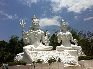 W
WKailasagiri is a hilltop park in the city of Visakhapatnam in the Indian state of Andhra Pradesh. The park was developed by the Visakhapatnam Metropolitan Region Development Authority (VMRDA) and comprises 380 acres (150 ha) of land covered with flora and tropical trees. The hill, at 173 metres (568 ft), overlooks the city of Visakhapatnam.
 W
WKanithi Balancing Reservoir (KBR) is a reservoir in Ukkunagaram, Visakhapatnam, India. It is the water source for the entire Vizag steel plant and steel plant township.
 W
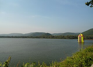
WKondakarla Ava is a famous Lake and Bird Sanctuary in Visakhapatnam of Andhra Pradesh state in South India. It comprises a unique and endangered forest type. It is located in the foothills of Eastern Ghats.
 W
WMeghadri Gedda Reservoir is a reservoir in Visakhapatnam, India. It is one of the main water source for the entire Visakhapatnam city.. This reservoir capacity is 11 MGD and maintained by Greater Visakhapatnam Municipal Corporation..
 W
WMudasarlova Reservoir is a reservoir in Visakhapatnam which covers 25 hectares and has a flow of 1.5MGD. The Government of Andhra Pradesh built a floating solar power plant with a 2MW capacity on the reservoir.
 W
WPavurallakonda or Pavurallabodu is the local name of a hill, popularly known as Narasimhaswamy Konda, near Bheemunipatnam about 25 km towards north of Visakhapatnam, in the Indian state of Andhra Pradesh. It is located at a height of about 150 meters above mean sea level.
 W
WRaiwada Reservoir is a reservoir in Devarapalle Village, 58km from Visakhapatnam city. It is one of the main water sources for Visakhapatnam city. Its capacity is 2,360 tcm, and it is maintained by Irrigation & CAD Dept.
 W
WRK Beach also known as Ramakrishna Beach is situated on the East coast of Bay of Bengal in Visakhapatnam, Andhra Pradesh. It is located near Dolphin's Nose.
 W
WRushikonda Beach located in Visakhapatnam on the coast of Bay of Bengal in the Indian state of Andhra Pradesh. The beach is maintained by the state tourism board, APTDC.
 W
WThe Simhachala Hill Range, with the anglicised name Simhachalam Hills, are a towering mountain range near the city of Visakhapatnam, in Andhra Pradesh state, southern India. It is one of the hill ranges in Andhra Pradesh and in the Eastern Ghats.
 W
WYarada Beach is situated on the west coast of Bay of Bengal in Yarada, a village at a distance of 15 kilometres (9.3 mi) from Visakhapatnam. It is located near Gangavaram beach, Dolphin's Nose, and Gangavaram Port.. This is a very picturesque beach in Andhra pradesh.
 W
WThe Yarada Hills are a range of hills at Yarada to the south of Visakhapatnam City beside the Bay of Bengal in Andhra Pradesh state, India.