 W
WA hydrologic model is a simplification of a real-world system that aids in understanding, predicting, and managing water resources. Both the flow and quality of water are commonly studied using hydrologic models.
 W
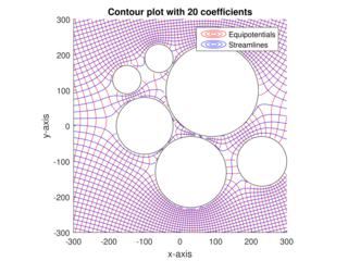
WThe analytic element method (AEM) is a numerical method used for the solution of partial differential equations. It was initially developed by O.D.L. Strack at the University of Minnesota. It is similar in nature to the boundary element method (BEM), as it does not rely upon discretization of volumes or areas in the modeled system; only internal and external boundaries are discretized. One of the primary distinctions between AEM and BEMs is that the boundary integrals are calculated analytically.
 W
WThe HBV hydrology model, or Hydrologiska Byråns Vattenbalansavdelning model, is a computer simulation used to analyze river discharge and water pollution. Developed originally for use in Scandinavia, this hydrological transport model has also been applied in a large number of catchments on most continents.
HydroGeoSphere (HGS) is a 3D control-volume finite element groundwater model, and is based on a rigorous conceptualization of the hydrologic system consisting of surface and subsurface flow regimes. The model is designed to take into account all key components of the hydrologic cycle. For each time step, the model solves surface and subsurface flow, solute and energy transport equations simultaneously, and provides a complete water and solute balance.
 W
WAn hydrological transport model is a mathematical model used to simulate the flow of rivers, streams, groundwater movement or drainage front displacement, and calculate water quality parameters. These models generally came into use in the 1960s and 1970s when demand for numerical forecasting of water quality and drainage was driven by environmental legislation, and at a similar time widespread access to significant computer power became available. Much of the original model development took place in the United States and United Kingdom, but today these models are refined and used worldwide.
 W
WAn isochrone map in geography and urban planning is a map that depicts the area accessible from a point within a certain time threshold. An isochrone is defined as "a line drawn on a map connecting points at which something occurs or arrives at the same time". In hydrology and transportation planning isochrone maps are commonly used to depict areas of equal travel time. The term is also used in cardiology as a tool to visually detect abnormalities using body surface distribution.
 W
WMETRIC is a computer model developed by the University of Idaho, that uses Landsat satellite data to compute and map evapotranspiration (ET). METRIC calculates ET as a residual of the surface energy balance, where ET is estimated by keeping account of total net short wave and long wave radiation at the vegetation or soil surface, the amount of heat conducted into soil, and the amount of heat convected into the air above the surface. The difference in these three terms represents the amount of energy absorbed during the conversion of liquid water to vapor, which is ET. METRIC expresses near-surface temperature gradients used in heat convection as indexed functions of radiometric surface temperature, thereby eliminating the need for absolutely accurate surface temperature and the need for air-temperature measurements.
 W
WThe Mississippi River Basin Model Waterways Experiment Station, located near Clinton, Mississippi, was a large-scale hydraulic model of the entire Mississippi River basin, covering an area of 200 acres. The model was built from 1943 to 1966 and in operation from 1949 until 1973. By comparison, the better known San Francisco Bay Model covers 1.5 acres and the Chesapeake Bay Model covers 8 acres. The model is now derelict, but open to the public within Buddy Butts Park, Jackson.
 W
WMODFLOW is the U.S. Geological Survey modular finite-difference flow model, which is a computer code that solves the groundwater flow equation. The program is used by hydrogeologists to simulate the flow of groundwater through aquifers. The source code is free public domain software, written primarily in Fortran, and can compile and run on Microsoft Windows or Unix-like operating systems.
 W
WA rainfall simulator is used in soil science and hydrology to study how the soil reacts to rainfall. Natural rainfall is difficult to use in experimentation because the timing and intensity of rainfall events cannot be reliably reproduced. Using simulated rainfall events significantly speeds the study of erosion, surface runoff, and leaching.
 W
WA runoff model is a mathematical model describing the rainfall–runoff relations of a rainfall catchment area, drainage basin or watershed. More precisely, it produces a surface runoff hydrograph in response to a rainfall event, represented by and input as a hyetograph. In other words, the model calculates the conversion of rainfall into runoff. A well known runoff model is the linear reservoir, but in practice it has limited applicability. The runoff model with a non-linear reservoir is more universally applicable, but still it holds only for catchments whose surface area is limited by the condition that the rainfall can be considered more or less uniformly distributed over the area. The maximum size of the watershed then depends on the rainfall characteristics of the region. When the study area is too large, it can be divided into sub-catchments and the various runoff hydrographs may be combined using flood routing techniques.
 W
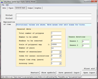
WSahysMod is a computer program for the prediction of the salinity of soil moisture, groundwater and drainage water, the depth of the watertable, and the drain discharge in irrigated agricultural lands, using different hydrogeologic and aquifer conditions, varying water management options, including the use of ground water for irrigation, and several crop rotation schedules, whereby the spatial variations are accounted for through a network of polygons.
 W
WSaltMod is computer program for the prediction of the salinity of soil moisture, groundwater and drainage water, the depth of the watertable, and the drain discharge (hydrology) in irrigated agricultural lands, using different (geo)hydrologic conditions, varying water management options, including the use of ground water for irrigation, and several cropping rotation schedules. The water management options include irrigation, drainage, and the use of subsurface drainage water from pipe drains, ditches or wells for irrigation.
SHETRAN is a hydrological modelling system for water flow, solute and sediment transport in river catchments. SHETRAN is a physically based, distributed model (PBDM) that can simulate the entire land phase of the hydrologic cycle including surface water flow and groundwater flow. The plan area of the catchment in SHETRAN is usually in the range of one to a few thousand square kilometres and the horizontal depth of the subsurface is usually less than 100m.
 W
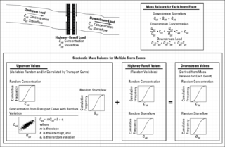
WThe stochastic empirical loading and dilution model (SELDM) is a stormwater quality model. SELDM is designed to transform complex scientific data into meaningful information about the risk of adverse effects of runoff on receiving waters, the potential need for mitigation measures, and the potential effectiveness of such management measures for reducing these risks. The U.S. Geological Survey developed SELDM in cooperation with the Federal Highway Administration to help develop planning-level estimates of event mean concentrations, flows, and loads in stormwater from a site of interest and from an upstream basin. SELDM uses information about a highway site, the associated receiving-water basin, precipitation events, stormflow, water quality, and the performance of mitigation measures to produce a stochastic population of runoff-quality variables. Although SELDM is, nominally, a highway runoff model is can be used to estimate flows concentrations and loads of runoff-quality constituents from other land use areas as well. SELDM was developed by the U.S. Geological Survey so the model, source code, and all related documentation are provided free of any copyright restrictions according to U.S. copyright laws and the USGS Software User Rights Notice. SELDM is widely used to assess the potential effect of runoff from highways, bridges, and developed areas on receiving-water quality with and without the use of mitigation measures.. Stormwater practitioners evaluating highway runoff commonly use data from the Highway Runoff Database (HRDB) with SELDM to assess the risks for adverse effects of runoff on receiving waters.
 W
WVflo is a commercially available, physics-based distributed hydrologic model generated by Vieux & Associates, Inc. Vflo uses radar rainfall data for hydrologic input to simulate distributed runoff. Vflo employs GIS maps for parameterization via a desktop interface. The model is suited for distributed hydrologic forecasting in post-analysis and in continuous operations. Vflo output is in the form of hydrographs at selected drainage network grids, as well as distributed runoff maps covering the watershed. Model applications include civil infrastructure operations and maintenance, stormwater prediction and emergency management, continuous and short-term surface water runoff, recharge estimation, soil moisture monitoring, land use planning, water quality monitoring, and water resources management.
 W
WWAFLEX is a spreadsheet-based model. It can be used to analyse upstream-downstream interactions, dam management options and water allocation and development options.