 W
WCarska Bara is the largest individual bog in Serbia, in the municipality of Zrenjanin. Along with the neighboring pond of Stari Begej it forms the Special nature reserve "Carska Bara".
 W
WDeliblato Sands is a large sand area covering around 300 km2 (120 sq mi) of ground in Vojvodina province, Serbia. It is located in southern Banat, situated between the river Danube and the southwestern slopes of the Carpathian Mountains. The sands are named after the village of Deliblato, in the municipality of Kovin. Its main masses are elliptical shaped hills with steppe grassland plains and steppe forests.
 W
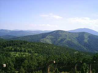
WGoč is a mountainous area in central Serbia, about 15 km south of the spa town of Vrnjačka Banja. Its highest peak Ljukten has an elevation of 1,216 m (3,990 ft) above sea level.
 W
WGornje Podunavlje Special Nature Reserve is a large protected area of wetland in the northwest of Serbia, on the Danube's left bank. It comprises two large marshes, Monoštorski Rit and Apatinski Rit and vast forests, meadows, ponds, swamps and the Danube's meanders, including 66 km (41 mi) of the Danube course. It is projected as a part of the future trans-boundary biosphere reserve "Mura-Drava-Danube", a five country project, dubbed the "Amazon of Europe".
 W
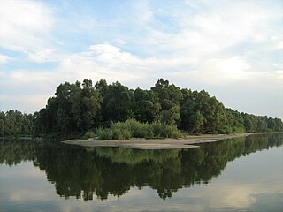
WIsland of Krčedin or Krčedinska Ada is a river island in Serbia. It is located on the left bank of the Danube across the village of Krčedin, in the municipality of Inđija, Autonomous Province of Vojvodina. The uninhabited island is part of the Special Natural Reserve "Koviljsko-Petrovaradinski Rit". It is one of the largest remaining natural pastures in the Podunavlje, known for the traditional stock breeding, with only basic human interference.
 W
WThe Jerma or Erma is a river in southeastern Serbia and western Bulgaria. Though not very long (72 km), it is notable for passing the Serbian-Bulgarian border twice.
 W
WThe Karađorđevo hunting ground is located in the northwest Serbia, along the left Danube bank. It lies 10 km north-west of Bačka Palanka, near the village of Karađorđevo. It covers an area of 69.14 square kilometres (26.70 sq mi). The property is state-owned, and managed by an establishment of the Army of Serbia. Since its establishment as a state property of the Austro-Hungarian Empire in 1885, it has served as a representative hunting ground and resort for statesmen, high-ranking military officials and businessmen. A part of the property is protected as a special nature reserve, occupying the area of 25.53 square kilometres (9.86 sq mi).
 W
WLabudovo okno is a special nature reserve and a Ramsar site in Serbia.
 W
WLudaš or Ludoš Lake is a shallow lake in the province of Vojvodina in northern Serbia, near Subotica. It is a special natural preserve and, since 1977, designated as a swamp area of international significance by the Ramsar Convention. The name of the lake stems from Hungarian "ludas", meaning goose.
 W
WObedska bara is a large swamp-forest area and natural reserve stretching along the Sava River in Southern Syrmia (Serbia), some 40 km west of Belgrade.
 W
WOkanj is a saline oxbow lake situated near the village of Elemir in the Zrenjanin commune, western Banat, Vojvodina Province, Serbia. It was formed from a meander of the Tisa River and is now about 4.5 kilometres (2.8 mi) from the river's left bank.
 W
WSuva Planina is a mountain in southeastern Serbia. It lies between the towns of Niška Banja to the northwest and Babušnica to the southeast, with a ridge branching towards Bela Palanka to the north. It was previously called Kunovica.
 W
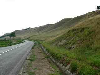
WTitelski Breg or Titel Hill is a loess plateau situated in the Vojvodina province, Serbia. It is located in south-eastern Bačka, between the town of Titel in the south, the villages of Lok, Vilovo and Šajkaš in the south-west, the village of Mošorin in the north, and the river Tisa in the east. It is 18 km long and 7.5 km wide, with steep cliffs, up to 60 m high along the Tisa. The hill has a flat top with an elevation of around 100 to maximally 128 m. The cliffs and the flat top give it a mesa-like appearance. The hill is an interesting geographical feature because it is the only hill in Bačka region, most of which is a flat plain. It is a loess formation deposited during the Pleistocene, showing six distinct bands, visible in gullies at the edge.
 W
WTrešnjica is a river in western Serbia. The source of the river is situated on the Povlen mountain. After 23 km the Trešnjica joins the Drina near Ljubovija.
 W
WThe Uvac is an international trans-boundary river, rising under Golija mountain and Pešter plateau, then flowing through southwestern Serbia and cross into eastern Bosnia and Herzegovina where, after 115 km, it finally meets the Lim river from the right, however, before it empties into the Lim, for a 10 kilometers Uvac forms the border between two countries. Also, while meandering through Serbia, Uvac loosely makes the northern border of the Raška region, too.
 W
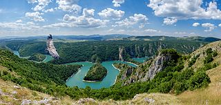
WUvac Special Nature Reserve is a special nature reserve of the category I in Serbia. It is known for the successful project of the preservation of the griffon vulture.
 W
WThe Zasavica is a bog in the region of Mačva, west-central Serbia. With Obedska bara and Carska Bara one of the major wildlife refuges and one of the last authentically preserved wetlands in Serbia. In the 2000s it became a popular attraction with the successful reintroduction of beavers, which had become extinct 100 years before.