 W
WAddi Remets or Adi Ramets is a town in Tigray Region of Ethiopia. Located in the Mi'irabawi (Western) Zone of the Tigray Region, this town has a latitude and longitude of 13°45′N 37°19′E with an elevation of 1870 meters above sea level. It is the administrative center of Wolqayt woreda.
WAlamata is a town and separate woreda of in Ethiopia. Located in the Debubawi (Southern) zone of the Tigray Region, it has a latitude and longitude of 12°25′N 39°33′E and an elevation of 1,520 metres (4,990 ft) above sea level and is located along Ethiopian Highway 2. It is surrounded by Alamata woreda.
 W
WAlitena is a town in northern Ethiopia, located in the Misraqawi (Eastern) Zone of the Tigray Region. Alitena was the administrative center of Irob woreda until Dawhan was made the new center in 2003.
WDansha is a town in Tigray, Ethiopia, located in the northwestern part of the country.
 W
WDar'a is an area in the eastern Tigray Region of northern Ethiopia. The city of `Addi Galamo, where many pre-Aksumite D`mt and Aksumite artifacts have been found is located in Dar'a.
WEdaga Arbi is a town in the Tigray Region of Ethiopia, 42 km south east of Adwa. It is the administrative and economic center of the Werie Lehe woreda. Edega Arbi is mainly known for its monastery.
WEnticho is a town in northern Ethiopia. Located on the Inguya River in the Mehakelegnaw (Central) Zone of the Tigray Region, it has a latitude and longitude of 14°16′N 39°09′E with an elevation of 1964 meters above sea level. It is the administrative center of Enticho woreda.
 W
WFreweyni is a town in northern Ethiopia. Located 80 kilometers north of Mekele in the Misraqawi Zone of the Tigray Region of Ethiopia, this town has a latitude and longitude of 14°3′N 39°34′E with an elevation of 2480 meters above sea level and is located along Ethiopian Highway 2.
 W
WLake Hashenge is a lake in the southern Tigray Region of Ethiopia. Located in the Ethiopian highlands at an elevation of 2409 meters, it has no outlet. According to the Statistical Abstract of Ethiopia for 1967/68, Lake Hashenge is five kilometers long and four wide, with a surface area of 20 square kilometers.
 W
WThe Lioness of Gobedra is a rock sculpture located in Gobo Dura (Gobedra), Ethiopia. It is a representation of a crouching lioness around three metres long, which was carved into a relief on a large phonolite rock outcropping situated two kilometers west of Axum. It was first described by German archeologists in 1913.
WMekoni, also Mehoni, is a town in the Tigray Region of Ethiopia. "Mekoni" is located at 657 km north of Addis Ababa along Ethiopian Highway 2 which runs to Mekelle, Adigrat, Aksum, Shire and Humera with an altitude of 2479 m.
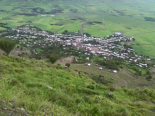
WSamre is a town in northern Ethiopia. Located in the Debub Misraqawi (south-eastern) Zone of the Tigray Region, this town has a latitude and longitude of 13°11′N 39°12′E with an elevation of 1855 meters above sea level. It is one of two towns in Saharti Samre woreda.
 W
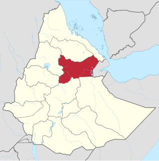
WSemien Mi'irabawi or Semien Mi'irab, meaning "North Western", is one of the Zones in the Tigray Region of Ethiopia. It is bordered on the east by the Maekelay (Central) Zone, the south by the Amhara Region, the west by the Mi'irabawi (Western) Zone and on the north by Eritrea. The Zone is subdivided into the six woredas (districts) of Asigede Tsimbela, La'ilay Adiyabo, Medebay Zana, Tahtay Adiyabo, Tahtay Koraro and Tselemti. Major towns and cities in the zone include Inda Selassie, Sheraro, Inda Aba Guna, Selekleka, Adi Daero, May Tsebri. Semien Mi'irabawi was split off from Mi'irabawi Zone in 2005.
WShire Airport, also known as Indaselassie Airport, is an airport serving Shire, a city in the Tigray National Regional State of Ethiopia. The airport is just south of the city.
 W
WWollo is a historical region and province in the northeastern part of Ethiopia, with its capital city at Dessie. The name "Wello" represents the Wello Oromo clan.
WYechila is a town in northern Ethiopia. Located in the Mehakelegnaw Zone of the Tigray Region, this town has a latitude and longitude of 13°17′N 39°00′E with an elevation of 1571 meters above sea level. It is located in the Mearey-tabia and is the administrative center of Abergele woreda.
 W
WZatta is one of the woreda within the [[Districts of EthiopiaTigray Region of Ethiopia. Part of the Debubawi Zone. Zata is bordered with Amhara region with a river called Tslare ( ጽላረ) which flows into the Tekezé River.