 W
WThe Birdsville Track is a notable outback road in Australia. The 517 kilometres (321 mi) track runs between Birdsville in south-western Queensland and Marree, a small town in the north-eastern part of South Australia. It traverses three deserts along the route, the Strzelecki Desert, Sturt Stony Desert and Tirari Desert.
 W
WThe Bore Track is a 4WD track in South Australia roughly following the Queensland border from Cameron Corner to Innamincka. It is a narrow, rarely used, scenic alternative to the Strzelecki Track, passing through sand dunes and clay pans of the Strzelecki Desert. It is a good preparation for the longer traverse of the Simpson desert. There are gas fields, pipelines and bores for which the track is the historic access and after which it is named.
 W
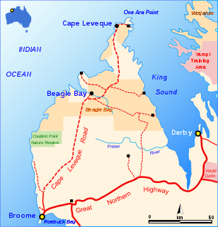
WThe Cape Leveque Road is a regional Western Australian road that runs through pindan woodland for 205 kilometres (127 mi) between Broome and Cape Leveque on the Dampier Peninsula.
 W
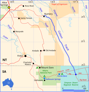
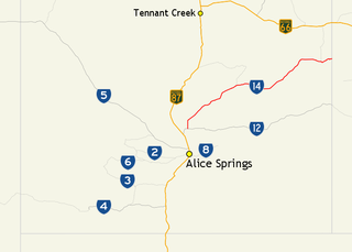
WThe Colson Track is a remote dirt track in Australia running between the Simpson Desert in South Australia and Numery Station in the Northern Territory. It is named in honour of Ted Colson, the first person of European descent to make a successful crossing of the Simpson Desert on foot.
 W
WDuncan Road is a generally northeast-southwest former highway in the northeast of Western Australia and northwest of Northern Territory which links the Victoria Highway with Halls Creek. The road, approximately 443 kilometres (275 mi) in length, was designated as National Route 80 from its terminus at Halls Creek through to Nicholson. National Route 80 continued east into the Northern Territory along Buntine Highway, while Duncan Road snakes its way north, crossing the Western Australia / Northern Territory borders numerous times between Buntine Highway and Victoria Highway.
 W
WThe Gibb River Road is a road in the Kimberley region of Western Australia.
 W
WThe Great Central Road is a mostly unsealed Australian outback highway that runs 1,126 km (700 mi) from Laverton, Western Australia to Yulara, Northern Territory. It passes through a number of small communities on the way.
 W
WThe Gunbarrel Road Construction Party (GRCP) was the name bestowed upon a team of road builders by Len Beadell in 1955, after which the well known outback track Gunbarrel Highway was named. Over a period of eight years, Beadell and the GRCP built more than 6,000 kilometres of dirt roads in remote areas of central Australia for the Weapons Research Establishment at Woomera, South Australia. By the time they had completed their work in December 1963, the GRCP had built eleven major roads in twenty-four separate stages across South Australia, the Northern Territory and Western Australia.
 W
WThe Kalumburu Road in the Kimberley Region of Western Australia is a 267 kilometre unsealed road that connects the Gibb River Road to the aboriginal community of Kalumburu on the coast via the Mitchell Plateau. The road, which often becomes inaccessible during the wet season, is suitable for four-wheel drive traffic and facilities are limited to supplies available at the roadhouse at the Drysdale River Station. Kalumburu Road runs north from the Gibb River Road, which it intersects approximately 250 km west of Kununurra. It also provides visitors access to Mitchell Falls.
 W
WThe Maralinga to Emu Road is a remote unsealed outback track that links Maralinga to Emu in the western region of South Australia. It was built by Len Beadell for the Weapons Research Establishment of Salisbury, South Australia in 1955.
 W
WThe Mount Davies Road is a remote unsealed outback track which runs from Mount Davies (Pipalyatjara) in the far north-west corner of South Australia to Anne's Corner on the Anne Beadell Highway 397 kilometres to the south-east. It was built during 1956 and 1957 by the Gunbarrel Road Construction Party (GRCP) surveyed and led by Len Beadell for the Weapons Research Establishment at Woomera, South Australia.
 W
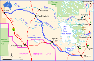
WThe Oodnadatta Track is an unsealed 617 km (383 mi) outback road in the Australian state of South Australia passing from Marree in the south-east to Marla in the north-west via Oodnadatta. Along the way, the track passes the southern lake of the Kati Thanda-Lake Eyre National Park, the settlements of William Creek and Oodnadatta, and mound springs known as Freeling Springs, Strangways Springs, and The Bubbler and Blanche Cup.
 W
WThe Plenty Highway is a 498-kilometre (309 mi) outback mostly unsealed road in the Northern Territory of Australia between the Stuart Highway and north-western Queensland.
 W
WThe Sandover Highway is an outback unsealed track in the Northern Territory between the Plenty Highway north of Alice Springs and the Northern Territory/Queensland border.
 W
WThe Simpson Desert is a large area of dry, red sandy plain and dunes in Northern Territory, South Australia and Queensland in central Australia. It is the fourth-largest Australian desert, with an area of 176,500 km2 (68,100 sq mi).
 W
WThe Strzelecki Track is an outback track in South Australia, mostly unsealed but with a few short sealed sections to facilitate overtaking, linking Innamincka to Lyndhurst. It passes through the Strzelecki Desert. The 475-kilometre (295-mile) track was pioneered by bushman Harry Redford in 1871 and is passable to conventional vehicles during the dry season, although caution is required. A shorter route is available via a public access road between Moomba and Innamincka, making the distance 458 kilometres.
 W
WThe Talawana Track is a remote unsealed track that runs between Windy Corner on the Gary Highway and the Marble Bar Road in Western Australia, a distance of 596 kilometres. The majority of it was built by Len Beadell and the Gunbarrel Road Construction Party in 1963 as part of a series of connecting roads for the Woomera rocket range in South Australia. It was the final road they built.
 W
WThe Vokes Hill Corner to Cook Road is a remote unsealed outback track that links Vokes Hill Corner on the Anne Beadell Highway to Cook on the Trans-Australian Railway in the far west of South Australia. It was built by Len Beadell for the Australian Government's Weapons Research Establishment in late 1961.