 W
WA boundary marker, border marker, boundary stone, or border stone is a robust physical marker that identifies the start of a land boundary or the change in a boundary, especially a change in direction of a boundary. There are several other types of named border markers, known as boundary trees, pillars, monuments, obelisks, and corners. Border markers can also be markers through which a border line runs in a straight line to determine that border. They can also be the markers from which a border marker has been fixed.
 W
WThe State Line Marker is a historic boundary marker on the state line between Arkansas and Oklahoma. It is located down a path a short way north of a parking area on Talimena Scenic Drive in Ouachita National Forest, about 17 miles (27 km) northwest of Mena, Arkansas. The marker is an octagonal cast iron pipe, with the legend "48 M" on the north face, "1877" on the south side, "ARK" on the east side, and "CHOC" on the west side. The pipe is mounted in a stone and mortar base installed by the United States Forest Service in 1974. The marker was placed in 1877 following a series of controversial surveys to demarcate the border between Arkansas and what was then Indian Territory.
 W
WAlderman's Barrow is a bowl barrow on Exmoor. It was created as a burial chamber in the Bronze Age and subsequently became a marker for the boundary of the parishes of Exford, Exmoor, Luccombe and Porlock. It was known as Osmunesburgh in the 13th century, Owlaman's Burrow in the 17th century and was named Alderman's Barrow in 1782. It was protected as a scheduled monument in 1934.
 W
WThe boundary markers of the original District of Columbia are the 40 milestones that marked the four lines forming the boundaries between the states of Maryland and Virginia and the square of 100 square miles (259 km²) of federal territory that became the District of Columbia in 1801. Working under the supervision of three commissioners that President George Washington had appointed in 1790 in accordance with the federal Residence Act, a surveying team that Major Andrew Ellicott led placed these markers in 1791 and 1792. Among Ellicott's assistants were his brothers Joseph and Benjamin Ellicott, Isaac Roberdeau, George Fenwick, Isaac Briggs and an African American astronomer, Benjamin Banneker.
 W
WIn Germany, Burgfriedensäulen are former boundary signs that were erected as boundary stones at certain points in the terrain around a city or castle. The spatial scope of a castle trench was determined by the stones.
 W
WCharter Stones date back to ancient times when such stones were granted to individuals or communities in lieu of written charters to signify the granting of land by the crown, feudal overlords or other individuals. They were used to record ownership of land before written documents came into general use.
 W
WCoal-tax posts are boundary marker posts found in southern England. They were erected in the 1860s and form an irregular loop between 12 and 18 miles from London to mark the points where taxes on coal were due to the Corporation of London. There were originally around 280 posts of which around 210 remain.
 W
WThe Four Corners Monument marks the quadripoint in the Southwestern United States where the states of Arizona, Colorado, New Mexico, and Utah meet. It is the only point in the United States shared by four states, leading to the area being named the Four Corners region. The monument also marks the boundary between two semi-autonomous Native American governments, the Navajo Nation, which maintains the monument as a tourist attraction, and the Ute Mountain Ute Tribe Reservation.
 W
WThe Four Shire Stone is a boundary marker that marks the place where the four historic English counties of Warwickshire, Oxfordshire and Gloucestershire, and Worcestershire once met. Since 1931, with a change to the boundaries of Worcestershire, only three counties have met at the stone.
 W
WThe Initial Point of Boundary Between U.S. and Mexico is the westernmost boundary marker on the international boundary between the United States and Mexico and as such has since its erection and will throughout the future mark the southwestern corner of the Continental United States. According to the 1848 Treaty of Guadalupe Hidalgo, the initial border point is set as one marine league south of the southernmost point of San Diego Bay, and the border proceeds in a straight line towards the confluence of the Colorado River and Gila River.
 W
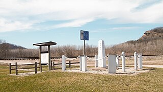
WIron Post is a historic boundary marker located in New Albin, Iowa, United States. An Act of Congress on March 3, 1849 sought to resolve the boundary issue between the State of Iowa and the newly established Minnesota Territory. This cast iron post was placed here by Captain Thomas Lee of the U.S. Army Corps of Topographical Engineers. He determined that North latitude 43 degrees, 30 minutes was indeed the border between the two entities, which the United States Congress had designated on August 4, 1846 as Iowa's northern border. It also served as a correction for the townships that had been established below the line, and as a practical surveying base for the territory to the north from this point all the way to the Big Sioux River.
 W
WLondon Stone is the name given to a number of boundary stones that stand beside the rivers Thames and Medway, which formerly marked the limits of jurisdiction of the City of London.
 W
WThe Mason and Dixon West Line Milestone Markers 76 and 77 are historic objects located in Frederick County, Maryland and Adams County, Pennsylvania, United States, near the community of Harney, Maryland. They are two of the original milestones that mark the Mason-Dixon line between the states of Maryland and Pennsylvania. Oolite limestone was quarried and carved on the Isle of Portland in the English Channel. Both were part of the third shipment of milestones and they arrived in Baltimore in June 1767. Stones from this shipment were placed in 1767 to mark mile 64 and miles 66 through 132 on the West Line. Both of these sites were surveyed on August 24, 1765. Milestone 76 was set on October 13, 1767. Milestone 77 was set the following day 125 yards (114 m) to the east of its true location, which is in the middle of Marsh Creek. It is one of two milestones intentionally offset due to the challenges of its true location.
 W
WThe Octonia Stone, also known as Octoney, Octeny, Octona, and Octuna Stone, is a historic boundary marker located near Stanardsville, Greene County, Virginia. The stone marks the terminus of the westernmost boundary line of the 24,000-acre Octonia Grant. It is a granite-type rock which is part of a natural outcropping in a hayfield. The stone is engraved with a figure 8, composed of two, nearly perfect circles, with a cross touching the top of the 8.
 W
WThe Peace Arch is a monument situated near the westernmost point of the Canada–United States border in the contiguous United States, between the communities of Blaine, Washington and Surrey, British Columbia. Construction of the 20.5-meter (67 ft) tall arch was headed by American lawyer Sam Hill and dedicated in September 1921. The Peace Arch commemorates the signing of the Treaty of Ghent in 1814, and symbolizes a long history of peace between the two nations. The monument is built on the exact U.S.–Canada boundary, where Interstate 5 on the U.S. side of the border becomes Highway 99 on the Canadian side, in the grass median between the northbound and southbound lanes.
 W
WStanedge Pole also known as Stanage Pole is a landmark on Hallam Moors close to Stanage Edge in South Yorkshire, England. Standing at a height of 438 metres, it marks the border between Derbyshire and South Yorkshire and can be seen for several miles around.
 W
WThe Tri-States Monument is a granite monument that marks the tripoint of the state boundaries of New Jersey, New York, and Pennsylvania. It is at the northwestern end of the boundary between New Jersey and New York, the northern end of the boundary between New Jersey and Pennsylvania, and the eastern end of the boundary between New York and Pennsylvania. The monument is located at the confluence of the Delaware and Neversink rivers. This location is also known as Carpenter's Point.
 W
WThe land border of the State of Western Australia (WA) bisects mainland Australia along 129th meridian east longitude. The border divides WA from the Northern Territory (NT) and South Australia (SA).