 W
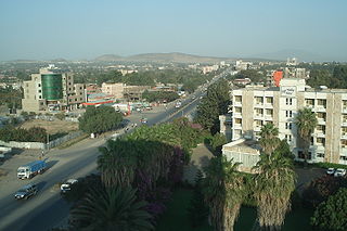
WAdama , officially known as Adaamaa and formerly Nazareth, is a city in central Oromia Region, Ethiopia. Adama forms a Special Zone of Oromia and is surrounded by East Shewa Zone. It is located at 8.54°N 39.27°E at an elevation of 1712 meters, 99 km southeast of Addis Ababa. The city sits between the base of an escarpment to the west, and the Great Rift Valley to the east.
 W
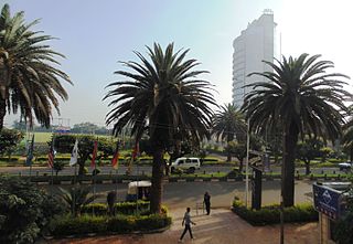
WAddis Ababa, also known as Finfinne(Oromo: Finfinne "natural spring"), is the capital and largest city of Ethiopia. According to the 2007 census, the city has a population of 2,739,551 inhabitants. As a chartered city, Addis Ababa also serves as the capital city of the Oromia Region. It is where the African Union is headquartered and where its predecessor the Organisation of African Unity (OAU) was based. It also hosts the headquarters of the United Nations Economic Commission for Africa (ECA), as well as various other continental and international organizations. Addis Ababa is therefore often referred to as "the political capital of Africa" for its historical, diplomatic and political significance for the continent. The city lies a few miles west of the East African Rift which splits Ethiopia into two, between the Nubian Plate and the Somali Plate. The city is surrounded by the Special Zone of Oromia and populated by people from different regions of Ethiopia. It is home to Addis Ababa University.
 W
WAdwa is a market town and separate woreda in Tigray, Ethiopia. It is best known as the community closest to the decisive Battle of Adwa fought in 1896 with Italian troops; the Ethiopian soldiers, aided by Russia and France, won the battle, thus being one of the few African nations to thwart European colonialism. Located in the Mehakelegnaw Zone of the Tigray Region, Adwa has a longitude and latitude of 14°10′N 38°54′E, and an elevation of 1907 meters. Adwa is surrounded by Adwa woreda.
 W
WArba Minch is a city and separate woreda in southern Ethiopia; the first common name for this city was Ganta Garo. Located in the Gamo Gofa Zone of the Southern Nations, Nationalities, and Peoples Region about 500 kilometers south of Addis Ababa, at an elevation of 1285 meters above sea level. It is the largest town in Gamo Gofa Zone and the second town in SNNPR next to Awassa. It is surrounded by Arba Minch Zuria woreda and the most resourceful zone in southern region including two largest Lakes in Ethiopia, more than 40 springs, National Nech sar park, crocodile market, several fruits including banana, apple, mango, avocado, etc.
 W
WAwassa is a city in Ethiopia, on the shores of Lake Awasa in the Great Rift Valley. It is 273 km (170 mi) south of Addis Ababa via Bishoftu, 130 km (81 mi) east of Sodo, and 75 km (47 mi) north of Dilla. The town serves as the capital of the Sidama Region and the Southern Nations, Nationalities, and Peoples' Region. It lies on the Trans-African Highway 4 Cairo-Cape Town and has a latitude and longitude of 7°3′N 38°28′E and an elevation of 1,708 meters (5,604 ft) above sea level. Its name comes from a Sidamic word meaning "wide body of water".
 W
WAxum or Aksum (; Tigrinya: ኣኽሱም; Ge'ez: አኵስም Ak̠ʷsəm; Amharic: አክሱም Ak̠sum, is a historical town in Tigray Region, Ethiopia and the site of the historic capital of the Aksumite Empire. It is now a tourist town with a population of 66,800 residents.
 W
WBahir Dar is a capital of the Amhara Region in Ethiopia and former capital of West Gojjam. Administratively, Bahir Dar is a Special Zone. Bahir Dar is one of the leading tourist destinations in Ethiopia, with a variety of attractions in the nearby Lake Tana and Blue Nile river. The city is known for its wide avenues lined with palm trees and a variety of colorful flowers. In 2002 it was awarded the UNESCO Cities for Peace Prize for addressing the challenges of rapid urbanization.
WBonga is a town and separate woreda in south-western Ethiopia. Located southwest of Jimma in the Keffa Zone of the Southern Nations, Nationalities and Peoples Region upon a hill in the upper Barta valley, it has a latitude and longitude of 7°16′N 36°14′E with an elevation of 1,714 meters above sea level. It is surrounded by Ginbo woreda. Bonga is the administrative center of the Keffa Zone, with a major market on Saturday and lesser ones on Tuesdays and Thursdays. Note that there is another town in Ethiopia named "Bonga", near Gambela.
WDilla is a market town and separate woreda in southern Ethiopia. The administrative center of the Gedeo Zone in the Southern Nations, Nationalities, and Peoples Region (SNNPR), it is located on the main road from Addis Ababa to Nairobi. The town has a longitude and latitude of 6°24′30″N 38°18′30″E, with an elevation of 1570 meters above sea level. It was part of Wenago woreda and is currently surrounded by Dila Zuria woreda.
WDimtu or Wolaita Dimtu or Bilate Tena is a town in south-central Ethiopia. It has an elevation between 1,000 and 1,600 metres above sea level. It was part of the former Damot Weyde (Woreda), near to Sodo Zuria woreda. It is now under the Diguna Fango woreda. Some writers mention the town as Bilate Tena in their books and journals. Among them Getahun Garedew Wodaje late Head Officer in Education Bureau of Southern Nations, Nationalities, and Peoples Region is the prior. On the book he wrote about "Local Adaptation Practices in Response to Climate Change in the Bilate River Basin, Southern Ethiopia", he used these two names, Dimtu and Bilate Tena, in the similar way.
 W
WDire Dawa is a city in eastern Ethiopia near Somali border and one of two chartered cities in Ethiopia. It is divided administratively into two woredas, the city proper and the non-urban woreda of Gurgura.
 W
WGondar or Gonder is a city and woreda in Amhara Region, Ethiopia. Located in the Semien Gondar Zone of the Amhara Region, Gondar is north of Tana Lake on the Lesser Angereb River and southwest of the Simien Mountains. It has a latitude and longitude of 12°36′N 37°28′E with an elevation of 2133 meters above sea level. As of 2016, Gondara has a population of 299,969.
WIrgalem locally known as Diko Dalle alternate names include Yirgalem, Abosto, Dalle) is a town in southern Ethiopia. Surrounded by Lakes Woyima and Gidawo, it is located 260 kilometers south of Addis Ababa and 40 kilometers south of Awasa in the Sidama Zone of the Southern Nations, Nationalities, and Peoples Region. The town has a latitude and longitude of 6°45′N 38°25′E and an elevation of 1776 meters. It is the largest settlement in Dale woreda.
 W
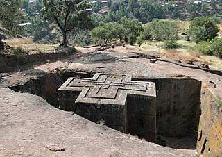
WLalibela is a town in Lasta Amhara Region, Ethiopia famous for its rock-cut monolithic churches. The whole of Lalibela is a large antiquity of the medieval and post-medieval civilization of Ethiopia. To Christians, Lalibela is one of Ethiopia's holiest cities, second only to Axum, and a center of pilgrimage. Unlike Axum, the population of Lalibela is almost completely Ethiopian Orthodox Christian.
 W
WMekelle, or Mekele, is the capital city of Tigray Region in Ethiopia. Mekelle was formerly the capital of Enderta awraja in Tigray. It is located around 780 kilometres (480 mi) north of the Ethiopian capital Addis Ababa, with an elevation of 2,254 metres (7,395 ft) above sea level. Administratively, Mekelle is considered a Special Zone, which is divided into seven sub-cities. Mekelle is the economic, cultural, and political hub of northern Ethiopia.
 W
WSemera is a new City Admistration on the Awash–Asseb highway in north-east Ethiopia, having been planned and built to replace Asaita as the capital of the Afar Region. Located in the Administrative Zone 1, Semera has a latitude and longitude of 11°47′32″N 41°0′31″E. One of the completed buildings is Semera University, which began holding classes in 2007.
WShashamane is a town in West Arsi Zone, Oromia Region, Ethiopia. The town lies on the Trans-African Highway 4 Cairo-Cape Town, about 150 miles (240 km) from the capital of Addis Ababa. It has a latitude of 7° 12' north and a longitude of 38° 36' east.
WWelkite is a town and separate woreda in south-western Ethiopia. The administrative center of the Gurage Zone of the Southern Nations, Nationalities and Peoples' Region (SNNPR), this town has a latitude and longitude of 8°17′N 37°47′E and an elevation between 1910 and 1935 meters above sea level. It is surrounded by Kebena woreda and it was part of former Goro woreda.