 W
WThe geography of Iraq is diverse and falls into five main regions: the desert, Upper Mesopotamia, the northern highlands of Iraq, Lower Mesopotamia, and the alluvial plain extending from around Tikrit to the Persian Gulf.
 W
WAl Khadraniyah is a village in Iraq. It is located west of River Tigris and north of Al-Shirqat. From 2014 until November 2016, it was under control of ISIL.
 W
Wal-Qaeda's Kurdish Battalions (AQKB) is a militant Islamist organization, primarily active in the northern Iran–Iraq border. It is the Kurdish branch of al-Qaeda that has launched several attacks on the Kurdistan Regional Government in northern Iraq. The group was classified as a terrorist organization by the US State Department on January 1, 2012.
 W
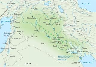
WThe Assyrian homeland or Assyria refers to areas inhabited by Assyrians. The areas that form the Assyrian homeland are parts of present-day Iraq, Turkey, Iran and more recently Syria as well. Moreover, the area that had the greatest concentration of Assyrians in the world until recently is located in the Assyrian Triangle.
 W
WAvroman or Hawraman, is a mountainous region located within the provinces of Kurdistan and Kermanshah in western Iran and in north-eastern Kurdistan Region of Iraq.
 W
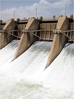
WThe Dibis (Dibbis) Dam or Dibis Regulator is a gravel-alluvial fill embankment dam located on Lesser Zab River approximately 130 km upstream from its confluence with the Tigris River. The dam is located directly north of the town of Dibis in Kirkuk Governorate, Iraq. The main-purpose of the Dibis Dam is to divert water from the Lesser Zab River into the Kirkuk Irrigation Project.
 W
WThe disputed territories of Northern Iraq are regions defined by article 140 of the Constitution of Iraq as being Arabised during Baath Party rule in Iraq. Most of these regions are inhabited by non-Arabs, including Kurds, Assyrians, Yazidis, Turkmens/Turkomans, and Shabaks.
 W
WThe Diyala River, is a river and tributary of the Tigris. It is formed by the confluence of Sirwan river and Tanjero river in Darbandikhan Dam in the Sulaymaniyah Governorate of Northern Iraq. It covers a total distance of 445 km (277 mi).
 W
WThe following outline is provided as an overview of and topical guide to Iraq:
 W
WKifri District is one of the six districts of Diyala Governorate in Iraq. Its main town is Kifri. The population was estimated at 42,010 in 2003.
 W
WLake Tharthar, and known in Iraq as Buhayrat ath-Tharthar, is an artificial lake opened in 1956, situated 100 kilometers northwest of Baghdad between the Tigris and the Euphrates rivers.
 W
WMesopotamia is a historical region of Western Asia situated within the Tigris–Euphrates river system, in the northern part of the Fertile Crescent, in modern days roughly corresponding to most of Iraq, Kuwait, the eastern parts of Syria, Southeastern Turkey, and regions along the Turkish–Syrian and Iran–Iraq borders.
 W
WMosul Dam, formerly known as Saddam Dam, is the largest dam in Iraq. It is located on the Tigris river in the western governorate of Nineveh, upstream of the city of Mosul. The dam serves to generate hydroelectricity and provide water for downstream irrigation. At full capacity, the structure holds about 11.1 cubic kilometres (2.7 cu mi) of water and provides electricity to the 1.7 million residents of Mosul.
 W
WNiheli is a Kurdish tribe and an area in Dohuk Governorate, Kurdistan Region in Iraq.
 W
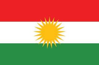
WThe Kurdistan Region is an autonomous region in northern Iraq comprising the four Kurdish-majority governorates of Dohuk, Erbil, Halabja and Sulaymaniyah and bordering Iran, Syria and Turkey. The Kurdistan Region encompasses most of Iraqi Kurdistan but excludes the disputed territories of Northern Iraq, contested between the Kurdistan Regional Government and the central Iraqi government in Baghdad since Southern Kurdish autonomy was realized in 1992 in the aftermath of the Gulf War. The Kurdistan Region Parliament is situated in Erbil, but the constitution of the Kurdistan Region declares the disputed city of Kirkuk to be the capital of the Kurdistan Region. When the Iraqi Army withdrew from most of the disputed areas in mid-2014 because of the ISIL offensive in Northern Iraq, Kurdish Peshmerga entered the areas and held control there until they surrendered the city to Iraqi government forces in October 2017.
 W
WSawa Lake is an Endorheic basin located in the Iraqi governorate of Muthanna near to the Euphrates River, some 23 kilometres (14 mi) to the west of Al-Samawa city. This lake has no inlet or outlet, but it draws water from the Euphrates through a system of joint cracks and fissures which transport water to aquifers beneath it. The water's level fluctuates during dry and wet seasons but does not dry up because of the equilibrium state between water feed and evaporation.
 W
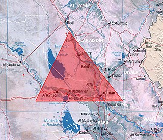
WThe Sunni Triangle is a densely populated region of Iraq to the north and west of Baghdad inhabited mostly by Sunni Muslim Arabs. The roughly triangular area's points are usually said to lie near Baghdad, Ramadi and Tikrit. Each side is approximately 125 kilometers long. The area also contains the cities of Samarra and Fallujah.
 W
WTurkmeneli, also known as Turkmenland, and historically as Turcomania, is a political term used to define the vast swath of territory in which the Iraqi Turkmens historically have had a dominant population. The term incorporates the Iraqi Turkmen/Turkoman homelands running from Iraq's border with Turkey and Syria and diagonally down the country to the border with Iran.