 W
WThe Aviemore Dam is a dam of the Waitaki River in New Zealand. Built from earth and concrete in the 1960s to dam Lake Aviemore, it is one of the major dams of Meridian Energy, and is used to power a hydroelectric power plant. It is a part of the Waitaki River Hydroelectric System, a scheme which supplies 30% of New Zealand's considerable amount of hydropower.
 W
WBendigo is a settlement and historic area in Central Otago, in the southern South Island of New Zealand. It is located some 20 kilometres to the north of Cromwell, to the east of the head of Lake Dunstan, on the banks of the Bendigo Creek, a small tributary of the Clutha River.
 W
WBerwick Forest is a large Pinus radiata (Pine) plantation at Berwick in New Zealand, around 40 km west of Dunedin. The forest lies close to the banks of the Waipori River immediately below and around the western end of Lake Mahinerangi, and consists of three blocks - the main block, Maungatua, and Waitahuna, with a total area of 13,141 hectares. The land is owned by Otago Land Company, a sub company of Boston-based investment company GMO LLC, the trees by Wenita Forest Products, which has shareholders Sinotrans (62%), the Chinese shipping company, and GMO.
 W
WThe Canterbury-Otago tussock grasslands are an ecoregion of South Island, New Zealand.
 W
WThe Catlins comprises an area in the southeastern corner of the South Island of New Zealand. The area lies between Balclutha and Invercargill, straddling the boundary between the Otago and Southland regions. It includes the South Island's southernmost point, Slope Point.
 W
WThe Central Otago wine region is a geographic indication in New Zealand's South Island, and the world's southernmost commercial wine growing region. Central Otago is best known for Pinot Noir, but many white wine varieties are also popular.
 W
WThe Dun Mountain-Maitai Terrane comprises the Dun Mountain Ophiolite Belt, Maitai Group and Patuki Mélange. The Dun Mountain Ophiolite is an ophiolite of Permian age located in New Zealand's South Island. Prehistorically this ophiolite was quarried by Māori for both metasomatized argillite and pounamu (jade) which was used in the production of tools and jewellery.
 W
WThe Haast Schist which contains both the Alpine and Otago Schist is a metamorphic unit in the South Island of New Zealand. It extends from Central Otago, along the eastern side of the Alpine Fault to Cook Strait. There are also isolated outcrops of the Haast Schist within the central North Island. The schists were named after Haast Pass on the West Coast. The Haast Schist can be divided geographically from north to south into the Kaimanawa, Terawhiti, Marlborough, Alpine, Otago and Chatham schist.
 W
WThe Hollyford Track is a tramping track in New Zealand. Located at the northern edge of Fiordland, in the southwestern South Island, it is unusual among Fiordland's major tracks in that it is largely flat and accessible year-round. It follows the Hollyford River which in turn follows the course of the Hollyford Valley.
 W
WKelso is an abandoned small settlement in Otago, New Zealand, located ten kilometres north of Tapanui on the Crookston Burn, close to its junction with the larger Pomahaka River. Its population during the 1960s and 1970s was close to 300, with most of its economy based on sheep farming. A small dairy factory was a focal point in the village's early years.
 W
WMacetown is an historic gold mining settlement in the Otago region of the South Island of New Zealand. It is now uninhabited but has become a tourist attraction. Access to the town is via an unsealed road that heads up the steep-sided Arrow gorge. This can be traversed on foot or by mountain bike, horse or four-wheel-drive vehicles. The road crosses the Arrow River or its side creeks 22 times and is not suitable for two-wheel-drive cars. The start of the road is found in the Arrowtown car park.
 W
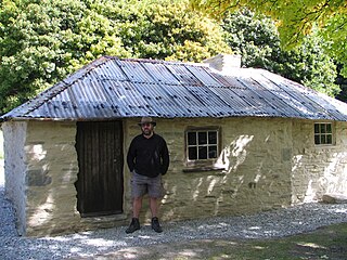
WMatanaka Farm is near Waikouaiti in Otago, New Zealand. The five buildings are the oldest surviving farm buildings that are still in their original position in the country. The farm is owned and administered by Heritage New Zealand. Additionally the buildings are registered as Category I and are considered "historically outstanding".
 W
WThe district of North Otago in New Zealand covers the area of Otago between Shag Point and the Waitaki River, and extends inland to the west as far as the village of Omarama.
 W
WOtago Harbour is the natural harbour of Dunedin, New Zealand, consisting of a long, much-indented stretch of generally navigable water separating the Otago Peninsula from the mainland. They join at its southwest end, 21 km (13 mi) from the harbour mouth. It is home to Dunedin's two port facilities, Port Chalmers and at Dunedin's wharf. The harbour has been of significant economic importance for approximately 700 years, as a sheltered harbor and fishery, then deep water port.
 W
WThe Southern Lakes is an unofficial name given to an area of the southern South Island of New Zealand. Despite being an unofficial designation, the term Southern Lakes is sometimes used by organisations such as the New Zealand Meteorological Service and Automobile Association. Though exact definitions vary, the area encompasses parts of western Southland and Central Otago, and is occasionally extended to include the Mackenzie Basin of inland Canterbury, a total of roughly 28,000 to 35,000 square kilometres.
 W
WThe Southland temperate forests is a temperate broadleaf and mixed forests ecoregion on New Zealand's South Island. The natural vegetation was mostly forest, but over the centuries human activities, including grazing and fires, replaced much of the original forest with grassland and agriculture.
 W
WThe St Bathans fauna is found in the lower Bannockburn Formation of the Manuherikia Group of Central Otago, in the South Island of New Zealand. It comprises a suite of fossilised prehistoric animals from the late Early Miocene (Altonian) period, with an age range of 19–16 million years ago.
 W
WThe Torlesse Composite Terrane is a plate tectonic terrane forming part of the South Island of New Zealand. It contains the Rakaia, Aspiring and Pahau Terranes and the Esk Head Belt. Greywacke is the dominant rock type of the composite terrane; argillite is less common and there are minor basalt occurrences. The Torlesse Composite Terrane is found east of the Alpine Fault in the Southern Alps of New Zealand. Its southern extent is a cryptic boundary with the Caples Terrane within the Haast Schists in Central Otago. It is named for the Torlesse Range in Canterbury.