 W
WThe 1899 San Ciríaco hurricane, also known as the 1899 Puerto Rico Hurricane or The Great Bahamas Hurricane of 1899, was the longest-lived Atlantic hurricane on record, and the second-longest-lived tropical cyclone globally on record after 1994's Hurricane John in the Pacific. It was also one of the deadliest Atlantic hurricanes in recorded history, with an estimated 3,800 fatalities. The third tropical cyclone and first major hurricane of the season, this storm was first observed southwest of Cape Verde on August 3. It slowly strengthened while heading steadily west-northwestward across the Atlantic Ocean and reached hurricane status by late on August 5. During the following 48 hours, it deepened further, reaching Category 4 on the modern day Saffir–Simpson hurricane wind scale (SSHWS) before crossing the Leeward Islands on August 7. Later that day, the storm peaked with winds of 150 mph (240 km/h). The storm weakened slightly before making landfall in Guayama, Puerto Rico with winds of 140 mph (220 km/h) on August 8. Several hours later, it emerged into the southwestern Atlantic as a Category 3 hurricane. The system paralleled the north coast of Dominican Republic and then crossed the Bahamas, striking several islands. Thereafter, it began heading northward on August 14, while centered east of Florida. Early on the following day, the storm re-curved northeastward and appeared to be heading out to sea. However, by August 17, it turned back to the northwest and made landfall near Hatteras, North Carolina early on the following day. No stronger hurricane has made landfall on the Outer Banks since the San Ciriaco hurricane.
 W
WThe 2005 Azores subtropical storm was the 19th nameable storm and only subtropical storm of the extremely active 2005 Atlantic hurricane season. It was not officially named by the US National Hurricane Center as it was operationally classified as a non-tropical low. The storm developed in the eastern Atlantic Ocean out of a low-pressure area that gained subtropical characteristics on October 4. The storm was short-lived, crossing over the Azores later on October 4 before becoming extratropical again on October 5. No damages or fatalities were reported during that time. After being absorbed into a cold front, the system went on to become Hurricane Vince, which affected the Iberian Peninsula.
 W
WHurricane Alex was the first Atlantic hurricane to occur in January since Hurricane Alice of 1954-1955. Alex originated as a non-tropical low near the Bahamas on January 7, 2016. Initially traveling northeast, the system passed by Bermuda on January 8 before turning southeast and deepening. It briefly acquired hurricane-force winds by January 10, then weakened slightly before curving towards the east and later northeast. Acquiring more tropical weather characteristics over time, the system transitioned into a subtropical cyclone well south of the Azores on January 12, becoming the first North Atlantic tropical or subtropical cyclone in January since Tropical Storm Zeta of 2005-2006. Alex continued to develop tropical features while turning north-northeast, and transitioned into a fully tropical cyclone on January 14. The cyclone peaked in strength as a Category 1 hurricane on the Saffir–Simpson scale with maximum sustained winds of 85 mph and a central pressure of 981 mbar. Alex weakened to a high-end tropical storm before making landfall on Terceira Island on January 15. By that time, the storm was losing its tropical characteristics; it fully transitioned back into a non-tropical cyclone several hours after moving away from the Azores. Alex ultimately merged with another cyclone over the Labrador Sea on January 17.
 W
WTropical Storm Ana was the first of two named tropical cyclones, along with Tropical Storm Arlene in 2017, on record in the North Atlantic basin to exist in the month of April. The first tropical cyclone of the 2003 season, it developed as a subtropical cyclone from a non-tropical low on April 20 to the west of Bermuda. It tracked east-southeastward and organized, and on April 21 it transitioned into a tropical cyclone with peak winds of 60 mph (95 km/h). Tropical Storm Ana turned east-northeastward, steadily weakening due to wind shear and an approaching cold front, and on April 24 it became an extratropical cyclone. The storm brushed Bermuda with light rain, and the remnants produced precipitation in the Azores and the United Kingdom. Swells generated by the storm capsized a boat along the Florida coastline, causing two fatalities.
 W
WHurricane Bonnie was a long-lived storm in the 1992 Atlantic hurricane season. It was the third tropical storm and second hurricane of the 1992 season. Bonnie formed at high latitudes in the central Atlantic on September 17. Devoid of any real steering currents for much of its lifespan, it was nearly stationary for over a week in the central Atlantic Ocean. On September 27, it began to slowly track east and northeast towards the Azores. Just before becoming extratropical, it affected the Azores on September 30, although no damage was reported.
 W
WHurricane Carrie was the strongest tropical cyclone of the 1957 Atlantic hurricane season. The third named storm and second hurricane of the year, Carrie formed from an easterly tropical wave off the western coast of Africa on September 2, a type of tropical cyclogenesis typical of Cape Verde-type hurricanes. Moving to the west, the storm gradually intensified, reaching hurricane strength on September 5. Carrie intensified further, before reaching peak intensity on September 8 as a Category 4 hurricane with maximum sustained winds of 140 mph (220 km/h) in the open Atlantic Ocean. The hurricane curved northwards and fluctuated in intensity as it neared Bermuda on September 14. However, Carrie passed well north of the island and turned to the northeast towards Europe. Weakening as it reached higher latitudes, the storm transitioned into an extratropical cyclone on September 23, prior to affecting areas of the British Isles, and subsequently dissipated on September 28.
 W
WHurricane Debbie was a moderate tropical cyclone which had significant impacts in Ireland as an extratropical cyclone. The fourth named storm of the 1961 Atlantic hurricane season, Debbie originated from a well-defined tropical disturbance that was first identified in late August over Central Africa. Tracking generally westward, the system moved off the coast of Senegal on September 5 into the Atlantic Ocean. By this time, it was estimated to have become a tropical depression, but forecasters did not issue advisories on the system until two days later. Late on September 6, Debbie passed through the southern Cape Verde Islands as a moderate tropical storm, resulting in a plane crash that killed 60 people in the islands. Once clear of the islands, data on the storm became sparse, and the status of Debbie was uncertain over the following several days as it tracked west-northwestward and later northward. It was not until a commercial airliner intercepted the storm on September 10 that its location became certain. The following day, Debbie intensified and reached its peak intensity as a Category 1 hurricane on the Saffir–Simpson hurricane scale, with maximum winds of 90 mph (150 km/h).
 W
WHurricane Emmy was the longest-lived hurricane of the 1976 Atlantic hurricane season. The fifth tropical cyclone and the third hurricane of the season, Emmy developed from a tropical wave on August 20 to the east of the Lesser Antilles. After changing its direction three times over several days, during which it reached a peak intensity of 105 mph (170 km/h), it turned to the east and slowly weakened. Emmy passed through the Azores on September 3, and a day later it was absorbed by approaching Hurricane Frances.
 W
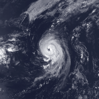
WHurricane Erika was the strongest and longest-lasting tropical cyclone in the 1997 Atlantic hurricane season. It developed from a tropical wave on September 3 and moved west-northwestward across the tropical Atlantic Ocean, steadily intensifying until it attained hurricane status on September 4, becoming the fifth named storm and third hurricane of the season. Erika passed a short distance to the north of the Lesser Antilles, and later turned to the north in response to an approaching trough. The hurricane quickly strengthened to become the only major hurricane of the season, reaching maximum sustained winds of 125 mph (205 km/h) on September 8; after maintaining its peak strength for 24 hours, Erika began to weaken as it passed over cooler waters. It turned to the east, weakened to a tropical storm, and became extratropical after passing near the Azores archipelago.
 W
WHurricane Fran, also referred initially as Subtropical Storm Bravo, was a long-tracked Category 1 hurricane that caused little damage during its existence in early October 1973. Originating from a tropical wave that developed off the coast of Hispaniola on October 1, the precursor to Fran slowly developing during the first week of October. By October 4, a surface low formed within the system and convective activity increased. The system was eventually classified as a subtropical depression on October 8 and was upgraded to Subtropical Storm Bravo shortly thereafter. Bravo became increasingly tropical throughout the day as it intensified. Following a reconnaissance mission into the storm on October 10, it was deemed fully tropical and upgraded to a hurricane, at which time it was renamed Fran.
 W
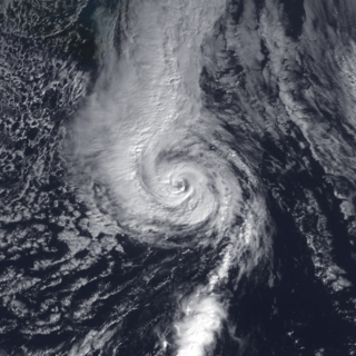
WHurricane Gordon was the first tropical cyclone since 1992 to affect the Azores while retaining tropical characteristics. The eighth tropical storm, third hurricane, and first major hurricane of the 2006 Atlantic hurricane season, Gordon formed on September 10 in the tropical Atlantic Ocean. It gradually matured into a hurricane as it tracked northward, reaching its peak intensity with winds of 195 km/h (121 mph) early on September 14 while located about 925 km (575 mi) southeast of Bermuda. After becoming nearly stationary, Gordon weakened to minimal hurricane status, although it re-intensified after accelerating to the east. It weakened again after moving over cooler waters, and passed through the Azores on September 20. Shortly thereafter, it became an extratropical cyclone and subsequently affected Spain, Ireland, and the United Kingdom.
 W
WTropical Storm Grace holds the record for being the farthest northeast forming tropical cyclone in the Atlantic basin. The seventh named storm of the slightly below average 2009 Atlantic hurricane season, Grace formed from an extratropical cyclone over the Azores on October 4. It strengthened to attain peak sustained winds of 65 mph (100 km/h) and developed an eye-like feature, although cold sea surface temperatures inhibited the development of thunderstorm activity near the center. The storm lost its tropical characteristics on October 6, and the storm's remnants merged with a separate system near the British Isles on October 7.
 W
WHurricane Leslie was the strongest cyclone of tropical origin to strike the Iberian Peninsula since 1842. A large, long-lived, and very erratic tropical cyclone, Leslie was the twelfth named storm and sixth hurricane of the 2018 Atlantic hurricane season. The storm had a non-tropical origin, developing from an extratropical cyclone that situated over the northern Atlantic on 22 September. The low quickly acquired subtropical characteristics and was classified as Subtropical Storm Leslie on the following day. The cyclone meandered over the northern Atlantic and gradually weakened, before merging with a frontal system on 25 September, which later intensified into a powerful hurricane-force extratropical low over the northern Atlantic.
 W
WHurricane Lorenzo, also known as Storm Lorenzo for Ireland and the United Kingdom while extratropical, was the easternmost Category 5 Atlantic hurricane on record. The twelfth named storm, fifth hurricane, third major hurricane and second Category 5 hurricane of the 2019 Atlantic hurricane season, Lorenzo developed from a tropical wave that moved off the west coast of Africa on 22 September, growing larger in size over the course of its development. On September 26, it rapidly intensified into a Category 4 hurricane before weakening due to an eyewall replacement cycle. After completing the cycle, Lorenzo rapidly restrengthened, peaking at Category 5 intensity. Steady weakening followed as the storm moved through unfavorable atmospheric conditions. Accelerating northeastward, Lorenzo skirted the western Azores on 2 October, and transitioned into an extratropical cyclone. The extratropical cyclone moved quickly towards Ireland and the United Kingdom and became the first named storm of the 2019–20 European windstorm season.
 W
WHurricane Nadine was the fourth-longest-lived Atlantic hurricane on record. The fourteenth tropical cyclone and named storm of the 2012 Atlantic hurricane season, Nadine developed from a tropical wave west of Cape Verde on September 10. By the following day, it had strengthened into Tropical Storm Nadine. After initially tracking northwestward, Nadine turned northward, well away from any landmass. Early on September 15, Nadine reached hurricane status as it was curving eastward. Soon after, an increase in vertical wind shear weakened Nadine and by September 16 it was back to a tropical storm. On the following day, the storm began moving northeastward and threatened the Azores but late on September 19, Nadine veered east-southeastward before reaching the islands. Nonetheless, the storm produced tropical storm force winds on a few islands. On September 21, the storm curved south-southeastward while south of the Azores. Later that day, Nadine transitioned into a non-tropical low pressure area.
 W
WHurricane Ophelia was regarded as the worst storm to affect Ireland in 50 years, and was also the easternmost Atlantic major hurricane on record. The tenth and final consecutive hurricane and the sixth major hurricane of the very active 2017 Atlantic hurricane season, Ophelia had non-tropical origins from a decaying cold front on 6 October. Located within a favorable environment, the storm steadily strengthened over the next two days, drifting north and then southeastwards before becoming a hurricane on 11 October. After becoming a Category 2 hurricane and fluctuating in intensity for a day, Ophelia intensified into a major hurricane on 14 October south of the Azores, brushing the archipelago with high winds and heavy rainfall. Shortly after achieving peak intensity, Ophelia began weakening as it accelerated over progressively colder waters to its northeast towards Ireland and Great Britain. Completing an extratropical transition early on 16 October, Ophelia became the second storm of the 2017–18 European windstorm season. Early on 17 October, the cyclone crossed the North Sea and struck western Norway, with wind gusts up to 70 kilometres per hour (43 mph) in Rogaland county, before weakening during the evening of 17 October. The system then moved across Scandinavia, before dissipating over Norway on the next day.
 W
WHurricane Tanya was the first named storm to start with a "T" in the Atlantic since naming began in 1950, and the final storm of the very active 1995 Atlantic hurricane season. The twenty-first tropical cyclone, nineteenth named storm, and eleventh hurricane of the season, Tanya developed from a tropical wave while well north of the Lesser Antilles on October 26. The system headed northeastward and strengthened into Tropical Storm Tanya on October 27. Tanya meandered around the central Atlantic, and further intensified into a hurricane on October 29. Thereafter, Tanya tracked northeastward before curving to the east-northeast. After switching to an eastward direction, Tanya weakened to a tropical storm on November 1. Later that day, Tanya passed through the Azores as it was transitioning into an extratropical cyclone.
WThe Azores, an autonomous region of Portugal in the northeastern Atlantic Ocean, has experienced the effects of at least 19 Atlantic hurricanes, or storms that were once tropical or subtropical cyclones. The most recent storm to affect the archipelago was Tropical Storm Sebastien in 2019.