 W
WThe Central African Republic is administratively divided into 16 prefectures and the capital city of Bangui, which is an autonomous commune.
 W
WBamingui-Bangoran is one of the 16 prefectures of the Central African Republic. It covers an area of 58,200 km² and had a population of 38,437 as of the 2003 census. The population density of 0.66/km² is the lowest in the country. The capital is Ndélé.
 W
WBangui is the capital and largest city of the Central African Republic. As of 2012 it had an estimated population of 734,350. It was established as a French outpost in 1889 and named after its location on the northern bank of the Ubangi River ; the Ubangi itself was named from the Bobangi word for the "rapids" located beside the settlement, which marked the end of navigable water north from Brazzaville. The majority of the population of the Central African Republic lives in the western parts of the country, in Bangui and the surrounding area.
 W
WBasse-Kotto is one of the 16 and the least populated prefecture of the Central African Republic. Its capital is Mobaye.
 W
WHaut-Mbomou is one of the 16 prefectures of the Central African Republic. Its capital is Obo. The African Pole of Inaccessibility is located here.
 W
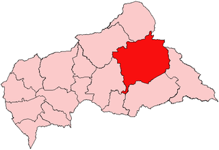
WHaute-Kotto is one of the 16 prefectures of the Central African Republic. Its capital is Bria. It is the largest prefecture in the Central African Republic.
 W
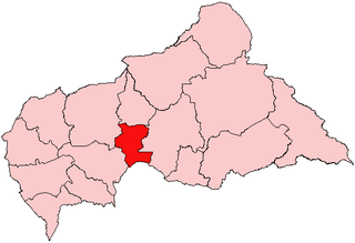
WKémo is one of the 16 prefectures of the Central African Republic. Its capital is Sibut.
 W
WLobaye is one of the 16 prefectures of the Central African Republic. Its capital is Mbaïki.
 W
WMambéré-Kadéï is one of the 16 prefectures of the Central African Republic. The prefecture covers 30,203 km2 and had a population of 289,688 as of the 2003 census, giving a population density of less than 10 inhabitants/km2. Its capital is Berbérati.
 W
WMbomou is one of the sixteen prefectures of the Central African Republic. It covers an area of 61,150 square kilometres (23,610 sq mi) and has a population of 132,740, giving a population density of only 2.2 inhabitants per square kilometre. The capital is Bangassou. Nearby are the Kembe Falls on the River Kotto. The prefecture is governed by Pierrette Benguere.
 W
WNana-Grébizi is one of the 16 prefectures of the Central African Republic. It covers an area of 19,996 km2 and has a population of 87,341. The capital is Kaga Bandoro.
 W
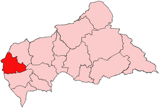
WNana-Mambéré is one of the 16 prefectures of the Central African Republic. It covers an area of 26,600 km2 and has a population of 233,666 (2003 census). The capital is Bouar. It was part of Kamerun when it was a German colony between 1884 and 1916.
 W
WOmbella-M'Poko is one of the 16 prefectures of the Central African Republic. Its capital is Bimbo.
 W
WOuaka is one of the 16 prefectures of the Central African Republic. It borders the Democratic Republic of the Congo, covers an area of 49,900 km2, and has a population of 224,076, giving a population density of under 5 inhabitants/km2. The capital is Bambari.
 W
WOuham is one of the 16 prefectures of the Central African Republic. Its capital is Bossangoa.
 W
WOuham-Pendé is one of the 16 prefectures of the Central African Republic. Its capital is Bozoum. The region contains several ghost towns such as Goroumo, Beogombo Deux and Paoua due to government forces ransacking them and armed bandits killing all the male inhabitants over the years from 2005 to 2008.
 W
WSangha-Mbaéré is one of the 16 prefectures of the Central African Republic. Its capital is Nola.
 W
WVakaga is one of the 16 prefectures of the Central African Republic. Its capital is Birao. It covers an area of 46,500 km2 and has a population of 37,595. The extremely low population density, less than 1 person/km2, is a result of the capture of the majority of the region's inhabitants by slave-traders from the Sudan in the second half of the nineteenth century. Vakaga is known for its oil reserves.