 W
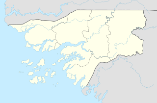
WBolama is an administrative region in Guinea-Bissau, consisting primarily of the Bijagós Archipelago of the country's southern coast, together with a small coastal strip centred on the coastal town of São João. It has an area of 2,624 km2. Its capital is Bolama, on the island of the same name. It is a coastal region covered with Mangrove swamps, rain forest and tangled forest and receives an annual rainfall of more than 1,000 mm (39 in).
 W
WBolama is the main town of Bolama Island and the capital of the Bolama Region. Though once the capital of Portuguese Guinea, it has a population of just 4,819 and much of its colonial era architecture is in a state of severe decay. The town is almost surrounded by mangrove swamps and is now mostly known for its production of cashew nuts.
 W
WBolama is the closest of the Bissagos Islands to the mainland of Guinea-Bissau. The island has a population of 6,024. It shares its name with ist largest settlement, the town Bolama, which is the capital of the island and the Bolama Region.
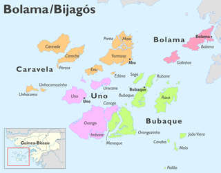
WBubaque is one of the Bijagós Islands in Guinea-Bissau, and is also the name of its main town. The island has a population of 6,427, the town Bubaque 4,299. The area of the island is 75 km², it is 13.6 km long and 8 km wide.
 W
WBubaque Airport is an airport serving the island town of Bubaque, in Guinea-Bissau. It is the Bijagos Archipelago's only airfield.
 W
WCarache is an island in the northwestern part of the Bissagos Islands group, Guinea-Bissau. It belongs to the Bolama Region and the sector of Caravela. Its area is 80.4 km², the island is 18.7 km long and 7.3 km wide. It is separated from the island of Caravela by a narrow channel. The largest villages on the island are Binte and Ampintcha. Its population is 428.
 W
WCaravela is the northernmost island of the Bissagos Islands of Guinea-Bissau, part of the Sector of Caravela, which also includes the islands Carache, Maio, Ponta and Formosa. The population of the sector is 4,263, the population of the island is 907. The area of the island is 128 km2, its length is 19.3 km and its width is 10 km. The island is heavily forested with mangroves. It has white, sandy beaches. Caravela has a small airfield. The island Carache lies to its southeast.
WFormosa is an island in the Bissagos Islands, Guinea-Bissau, part of the sector of Caravela. Its area is 140 km², its length is 19.9 km and its width is 10 km. It forms practically one island with Ponta and Maio, separated by creeks. The island has a population of 1,873 ; the largest village is Abú.
WGalinhas is an island in the Bijagós Archipelago of Guinea-Bissau. Galinhas is located about 25 km southwest of Bolama town. The Canal de Bolama separates it from Bolama Island, the easternmost island of the group that lies close to the mainland. The area of the island is 50 km2, its length is 10 km and its width is 6 km.
WThe João Vieira-Poilão Islands Marine National Park is a national park in Guinea-Bissau. It was established in August 2000. It covers 495 km2, and includes the uninhabited islands João Vieira, Cavalos, Meio and Poilão, in the southeastern part of the Bijagós Archipelago. The beaches of the islands are frequented by the sea turtle species Chelonia mydas, Eretmochelys imbricata and Lepidochelys olivacea.
WJoão Vieira is an island in the Bijagós Archipelago of Guinea-Bissau. Its population is 6. It is part of the João Vieira and Poilão Marine National Park. It lies 11 nmi (20 km) north-northeast of the island Poilão. Other nearby islands are Meio and Cavalos. The islands are important nesting grounds for sea turtles.
WOrango is one of the Bijagós Islands, located 60 kilometers off the coast of mainland Guinea-Bissau. At 272.5 km2 (105.2 sq mi), it is the largest island in the archipelago. The island has a population of 1,250 ; the largest village is Eticoga. With the neighbouring islands Imbone, Canongo, Meneque and Orangozinho it forms the Orango National Park. It belongs to the Uno Sector.
 W
WThe Orango National Park is a protected area in Guinea-Bissau. It was established in December 2000. The park has an area of 1,582 km2 (611 sq mi), which is partly marine. It covers the southern part of the Bissagos Archipelago, notably the islands Orango, Orangozinho, Meneque, Canogo and Imbone, and the surrounding sea. The marine area does not exceed 30 m (100 ft) depth. The park is administered by: Instituto da Biodiversidade e das Áreas Protegidas da Guiné-Bissau. About 160 km2 (60 sq mi) of the park is covered by mangroves. It plays a crucial role for the reproduction of molluscs, fish and sea turtles.
WOrangozinho is an island in the Bissagos Islands, Guinea-Bissau, it is part of the Bolama Region and the Bubaque sector. Its area is 107 km², its length is 19 km and its width is 11.8 km. It has a population of 706 ; the largest village is Wite. The island forms a part of the Orango National Park.
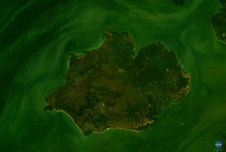
WPoilão is a small uninhabited island in the Bijagós Archipelago of Guinea-Bissau. It contains the country's southernmost point, at 10°51'53"N,15°43'36"W. It is part of the João Vieira and Poilão Marine National Park. The island is heavily forested. The nearest islands are Meio, 7 nmi (13 km) to the north, Cavalos, 9 nmi (17 km) to the north and João Vieira, 11 nmi (20 km) to the north-northeast. Its area is 43 ha. Between ca. 7000 and 29,000 green sea turtle nests are laid per year at the globally important site of Poilão Island. There is a lighthouse on the island, with focal height 27 m (89 ft).
 W
WRoxa or Canhabaque is an island in the Bissagos Islands, Guinea-Bissau. It is part of the sector of Bubaque. Its area is 111 square kilometres (43 sq mi); it is 20 kilometres (12 mi) long and 11 kilometres (6.8 mi) wide. The island has a population of 2,478, divided over the villages Ambuduco, Ampucute, Ancanhozinho, Indenazinho, Ancaguine, Ancatipe, Angaura, Indena Grande, Ga-Cote, Inore, Ambena, Bine, Inhoda, Idjoue, Eboco, Meneque, Ancanam, Anghudjiga, Anghumba and Antchurupe. There is a lighthouse on the east side of the island, its focal height is 26 m (85 ft).
 W
WRubane is one of the Bijagós Islands in Guinea-Bissau. The island has a population of 165. The island lies northeast of the larger island of Bubaque, across a narrow strait. It is part of the Boloma Bijagós Biosphere Reserve.
 W
WUno is an island in the Bissagos Islands, Guinea-Bissau. With the islands Eguba, Orango, Unhocomo, Unhocomozinho and Uracane it forms the sector of Uno. Its area is 104 km2 (40 sq mi). The island has a population of 3,324, the sector of Uno 6,751. It is part of the Boloma Bijagós Biosphere Reserve.
WUracane is an island in the Bissagos Islands of Guinea-Bissau. The island has a population of 1,181. It is part of the sector of Uno within the Bolama Region. It lies northeast of Uno, and south of Formosa.