 W
WThe Asia-Pacific is the part of the world in or near the Western Pacific Ocean. Asia-Pacific varies in area depending on context, but it generally includes East Asia, South Asia, Southeast Asia, and Oceania.
 W
WAtlantica, formally known as Atlantica: the International Northeast Economic Region (AINER), is the name of a proposed area of economic integration in the Atlantic Northeast of North America, incorporating parts of Canada and the United States.
 W
WThe Blue Banana is a discontinuous corridor of urbanization spreading over Western and Central Europe, with a population of around 111 million. The concept was developed in 1989 by RECLUS, a group of French geographers managed by Roger Brunet.
 W
WBosWash is a name coined by futurist Herman Kahn in a 1967 essay describing a theoretical United States megalopolis extending from the metropolitan area of Boston to that of Washington, D.C. The publication coined terms like BosWash, referring to predicted accretions of the Northeast, and SanSan for the urbanized region in Coastal California. The general concept for the area described by BosWash was first identified in French geographer Jean Gottmann's 1961 book Megalopolis: The Urbanized Northeastern Seaboard of the United States, although the term BosWash did not appear in the work.
 W
WCascadia is a bioregion and bioregional movement located within the western region of North America. Potential boundaries differ, with some drawn along existing political state and provincial lines, and others drawn along larger ecological, cultural, political, and economic boundaries. The boundaries are generally those defined by the Cascadia Bioregion.
 W
WCentral and Eastern Europe is a term encompassing the countries in Central Europe, the Baltics, Eastern Europe, and Southeast Europe, usually meaning former communist states from the Eastern Bloc in Europe. Scholarly literature often uses the abbreviations CEE or CEEC for this term. The Organisation for Economic Co-operation and Development (OECD) also uses the term "Central and Eastern European Countries (CEECs)" for a group comprising some of these countries.
 W
WThe Delmarva Peninsula, or simply Delmarva, is a large peninsula on the East Coast of the United States, occupied by the vast majority of the state of Delaware and parts of the Eastern Shore regions of Maryland and Virginia. The peninsula is 170 miles (274 km) long. In width, it ranges from 70 miles (113 km) near its center, to 12 miles (19 km) at the isthmus on its northern edge, to less near its southern tip of Cape Charles. It is bordered by the Chesapeake Bay on the west, and the Delaware River, Delaware Bay, and the Atlantic Ocean on the east.
 W
WA developing country is a country with a less developed industrial base (industries) and a low Human Development Index (HDI) relative to other countries. However, this definition is not universally agreed upon. There is also no clear agreement on which countries fit this category. A nation's GDP per capita, compared with other nations, can also be a reference point. In general, the United Nations accepts any country's claim of itself being "developing".
 W
WThomas P.M. Barnett is an American military geostrategist and former chief analyst at Wikistrat. He developed a geopolitical theory that divided the world into "the Functioning Core" and the "Non-Integrating Gap" that made him particularly notable prior to the 2003 U.S. Invasion of Iraq when he wrote an article for Esquire in support of the military action entitled "The Pentagon's New Map". The central thesis of his geopolitical theory is that the connections the globalization brings between countries are synonymous with those countries with stable governments, rising standards of living, and "more deaths by suicide than by murder". These countries form the Functioning Core. These regions contrast with those where globalization has not yet penetrated, which is synonymous with political repression, poverty, disease, and mass-murder, and conflict. These areas make up the Non-Integrating Gap.
 W
WThe Global South is an emerging term, used by the World Bank and other organizations, identifying countries with one side of the underlying global North–South divide, the other side being the countries of the Global North. As such the term does not inherently refer to a geographical south; for example, most of the Global South is actually within the Northern Hemisphere.
 W
WThe Golden Banana or Sun Belt is a term used by analysts when discussing urbanisation in a European context. It denotes an area of higher population density lying between Valencia in the west and Genoa in the east along the coast of the Mediterranean Sea, defined by the "Europe 2000" report from the European Commission in 1995 to be analogous to the Blue Banana.
 W
WThe Greater Middle East, also known as MENA or MENAP, is a political term, introduced in the early 2000s, denoting a set of contiguously connected countries stretching from the Maghreb region in the west all the way to Afghanistan in Central Asia, Greece in Southern Europe and Pakistan in South Asia. Various countries of Central Asia and Transcaucasia are sometimes also grouped together with countries from West Asia, North Africa, and the Horn of Africa. According to Andrew Bacevich in his book America's War for the Greater Middle East (2016), the career soldier and Professor Emeritus at Boston University states that this region is the theater for a series of conflicts dating back to 1980, which heralded the start of the Iran–Iraq War. Since then, the U.S. has been involved in balancing conflicts amongst these culturally interconnected nations in order to further its interests in the region. The Greater Middle East is sometimes referred to as the "New Middle East" or "The Great Middle East Project".
 W
WThe Jesusland map is an Internet meme created shortly after the 2004 U.S. presidential election that satirizes the red/blue states scheme by dividing the United States and Canada into "The United States of Canada" and "Jesusland". The map implies the existence of a fundamental political divide between contiguous northern and southern regions of North America, the former including both the socially liberal Canada and the West Coast, Northeastern, and Upper Midwestern states, and suggests that these states are closer in spirit to Canada than to the more conservative regions of their own country. The Freakonomics blog opined that the map reflected the "despair, division, and bitterness" of the election campaign and results. Slate also covered the image and posited that it might be the reason the Canadian immigration website received six times its usual page views the day after the election.
 W
WMacaronesia is a collection of four archipelagos in the North Atlantic Ocean off the coast of the continents of Europe and Africa. Each archipelago is made up of a number of Atlantic oceanic islands formed by seamounts on the ocean floor with peaks above the ocean's surface. The Macaronesian islands belong to three countries: Portugal, Spain, and Cape Verde. Politically, the islands belonging to Portugal and Spain are part of the European Union. Geologically, Macaronesia is part of the African Plate, including the Azores, which mark its edge at the meeting point with the Eurasian and North American Plates.
 W
WThe Nine Nations of North America is a 1981 book by Joel Garreau, in which the author suggests that North America can be divided into nine nations, which have distinctive economic and cultural features. He also argues that conventional national and state borders are largely artificial and irrelevant, and that his "nations" provide a more accurate way of understanding the true nature of North American society. The work has been called "a classic text on the current regionalization of North America".
 W
WThe North–South divide is a socio-economic and political division of Earth popularized in the late 20th century and early 21st century. Generally, definitions of the Global North is not exclusively a geographical term, and it includes Australia, Canada, most Western European countries, Israel, Japan, New Zealand, Singapore, South Korea, Taiwan (ROC) and the United States. The Global South is made up of Africa, Latin America and the Caribbean, Pacific Islands, and the developing countries in Asia, including the Middle East. It is home to: Brazil, India and China, which, along with Indonesia and Mexico, are the largest Southern states in terms of land area and population.
 W
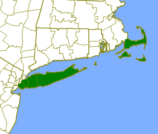
WThe Outer Lands is the prominent terminal moraine archipelagic region off the southern coast of New England in the United States. This eight-county region of Massachusetts, Rhode Island, and New York, comprises the peninsula of Cape Cod and the islands of Martha's Vineyard, the Elizabeth Islands, Nantucket, Block Island, the Narragansett Bay Islands, Staten Island, and Long Island, as well as surrounding islands and islets.
 W
WSoccsksargen, formerly known as Central Mindanao, is an administrative region of the Philippines, located in south-central Mindanao. It is numerically designated as Region XII. The name is an acronym that stands for the region's four provinces and one highly urbanized city. The regional center is in Koronadal located in the province of South Cotabato, and the center of commerce and industry is General Santos, which is the most populous city in the region.
 W
WTamazgha is a toponym in Berber languages denoting the lands traditionally inhabited by Berbers and which can also mean lands of the Imaziɣen in northern Africa. The region encompasses the geographical area between the Mediterranean Sea and the Niger River, a large swathe of territory spanning Morocco, Algeria, Tunisia, Libya, Mauritania, Mali, Niger, Egypt, Western Sahara, and the Canary Islands.