 W
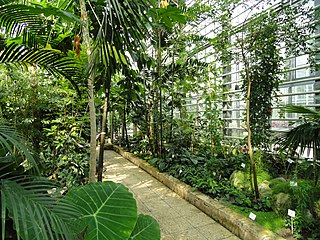
WThe Arboretum Freiburg-Günterstal is an arboretum maintained by the University of Freiburg. It is located in Günterstal in the Städtischen Forstamt Freiburg at Günterstalstraße 71, Freiburg, Baden-Württemberg, Germany, and open daily without charge.
 W
WArlesheimer See is an artificial lake within the boundaries of Freiburg im Breisgau district, in Baden-Württemberg, Germany. At an elevation of 212 m, its surface area is 0.060 km². It was first excavated in 1966. The lake, as well as 12 ha of forest surrounding it, is designated as a nature reserve, so the lake is not open for swimming. Due to the high number of found there, detected there, the lake is recognized as a European bird sanctuary under the Birds Directive.
 W
WBetzenhausen is a district in the west of Freiburg im Breisgau.
 W
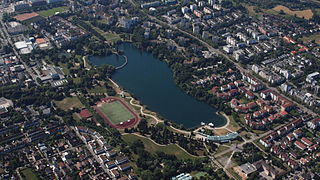
WThe Flückigersee (English: Lake Flückiger) is a 10-hectare lake in the Freiburg district of Betzenhausen.
 W
WFreiburg Botanical Garden is a botanical garden in the Herdern district at Schänzlestraße 1, Freiburg im Breisgau, Baden-Württemberg, Germany and is associated with the University of Freiburg as the "Forschungs- und Lehrgarten der Universität Freiburg" of the Faculty of Biology. The current director of the garden is Professor Dr. Thomas Speck.
 W
WStühlinger is a district to the west of the historic city center of Freiburg im Breisgau. In December 2013, 18,300 residents lived in the neighborhood. There are three boroughs: Stühlinger-Beurbarung, Stühlinger-Eschholz and Alt-Stühlinger. Although historically correct, the railroad Freiburg-Colmar is the north end of the Stühlinger and therefore Stühlinger-Beurbarung is not part of the district anymore. The district borders the area of the central train station of the Deutsche Bahn AG to the east, the river Dreisam to the south, tracks of the railroad freight transportation to the west and the district Brühl to the north.
 W
WFreiburg im Breisgau's parks, green spaces, recreational facilities, playgrounds, roadside greeneries and the Mundenhof add up to an area of 397 ha (3.97 km2), which corresponds to 18.05 m2 of green space per Freiburg citizen. On average, major cities in Baden-Württemberg have 22.66 m2 green space/citizen. However, there is an area of 2600 ha (26 km2) of forest in the close proximity of Freiburg as well as additional recreational area like the Rieselfeld district. The majority of the green spaces came into existence from the 1960s on.
 W
WHerdern is a suburb of Freiburg im Breisgau in Baden-Württemberg, Germany.
 W
WThe Lorettoberg, also known as Josephsbergle in Freiburg, is a mountain ridge in the South-West of the Wiehre district in the city of Freiburg im Breisgau in Germany. The mountain, with its elevation of 384,5 meters above sea level, is wooded at its peak. It divides the district Unterwiehre-Süd and borders the Vauban district in the West. 500 meters north of the “peak” there is a high spur 348m above sea level, next to which the eponymous Lorettokapelle is located. The name derives from Loreto, the second biggest Italian (Mary-) pilgrimage destination, after the St. Peter's Basilica in Rome. The Schloss-Café is located at the top of the mountain making the Lorettoberg a popular destination for a getaway, strolling and a local recreation area.
 W
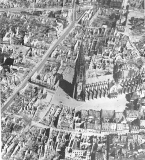
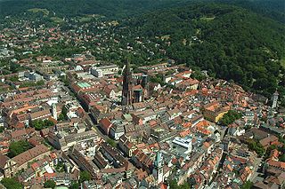
WThe Minster Square in the centre district of Freiburg is a paved area surrounding the Freiburger Minster. The city library, the Historical Merchants' Hall, the Wentzinger House and also the Korn House are located on this square. The Freiburger streams run along the sides of the square.
 W
WThe Mundenhof is located on the western edge of Freiburg im Breisgau, and is the smallest district in Freiburg, with only 46 residents. The zoo on the grounds of the Mundenhof is well-visited. The municipal garden center is also located on the grounds. The Mundenhof is one of many Green Spaces in Freiburg, which present a major factor in its reputation as a green city.
 W
WThe Musbachtal is a small 2.6 km long steep and narrow carved valley with a creek at the bottom. The valley stretches from the Carthusian monastery in Freiburg im Breisgau to below the summit of the Roßkopf. It is a side valley of the Dreisam valley and is heavily vegetated with mixed forest. It begins below the Rosskopf summit at an altitude of 463 m and ends in Freiburg's suburb Waldsee at an altitude of 320 m. There is also the Vogelsanghütte. Through the lower part of the valley runs a way of the cross which ends at the end of the valley at the St. Odile chapel. In the 18th century eight stations of the cross were erected by Wolfgang Kleiser on the footpath which starts at the Kartäuserstraße and ends at the upper end of the valley in a clearing. These stations were renovated in 2003. The beginnings of the pilgrimage through the Musbach valley were between the 7th and the 13th centuries and it had its heyday in the 16th century.
 W
WThe Old City of Freiburg is part of the city and business centres of Freiburg im Breisgau and is the core of the original city. It is divided into the two districts 111 Altstadt-Mitte and 112 Altstadt-Ring. The Altstadt-Mitte district was the city's build-up area at the time of its foundation and therefore formed the old city. The district Altstadt-Ring is connected westwards to the railway line and south to the Dreisam.
 W
WThe Platz der Alten Synagogue is a square in Freiburg, Germany. With a size of 130 square metres, it is the second largest square in the city after Minster Square. The square is named after the old synagogue, which was destroyed during the Kristallnacht in 1938. The synagogue had been built in 1869/1870 to the southwest of today's location of the square.
 W
WRieselfeld is a city district in Freiburg im Breisgau. It is located in the western part of the city and borders the nature reserve Freiburger Rieselfeld in the west, right next to a little zoo called Tiergehege Mundenhof, Opfinger Straße in the south and Besançonallee in the east. The industrial area Haid is part of the Sankt Georgen district and is located to the south of Rieselfeld, while the district Weingarten is situated to the east of Rieselfeld.
 W
WThe Schlossberg is a tree-covered hill of 456 metres (1,496 ft) located in the area of the city of Freiburg im Breisgau. It is directly to the east of Freiburg’s Old Town and belongs to the Black Forest. The main geological fault is at the western edge of the Schlossberg, towards the Upper Rhine Graben.
 W
WThe Seepark is a park in the district Betzenhausen of Freiburg im Breisgau which was constructed for the Landesgartenschau in 1986. It is a local recreation area, covering 35 hectares, and contains the Flückigersee, an artificial lake which takes up about 10 hectares. In the northeastern part of the park is the 15-meter tall Seepark Tower.
 W
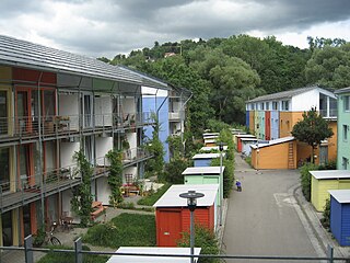
WVauban [] is a neighbourhood to the south of the town centre in Freiburg, Germany. It was built as "a sustainable model district" on the site of a former French military base named after Sébastien Le Prestre de Vauban, the 17th century French Marshal who built fortifications in Freiburg while the region was under French rule. Construction began in 1998, and the first two residents arrived in 2001.
 W
WWiehre is a residential district at the edge of Freiburg im Breisgau, located southwards and across the River Dreisam from the Old City. It is a desirable district, with comparatively quiet streets and many well-preserved commercial and residential buildings dating from the 18th century and earlier. Housing there is expensive relative to the rest of the city. The Wiehre is bordered on the west by the Rheintalbahn Karlsruhe-Basel, on the north by the Dreisam, on the east by the Waldsee, and on the south by a wood known as the Sternwald am Bromberg and the village of Günterstal. The Günterstal Landstrasse, which begins at the St. Martin's Gate in the ancient town wall, bisects the Wiehre.