 W
WBojana is a 41-kilometre-long (25 mi) river in Albania and Montenegro which flows into the Adriatic Sea. An outflow of Lake Skadar, measured from the source of the lake's longest tributary, the Morača, the Morača-Lake Skadar- Bojana system is 183 km (114 mi) long.
 W
WThe Buna River Velipoje Protected Landscape is a protected landscape area in northwestern Albania, encompassing the estuary of Drin, the lagoon of Viluni, the river of Buna with its estuary, and the gulf of Drin that runs across the city of Velipojë alongside the Adriatic Sea.
 W
WThe Cem, also known as the Cijevna, is a river that rises in Kelmend, Albania and, after nearly half of its length, crosses into Montenegro, where it flows into the River Morača near the capital, Podgorica.
 W
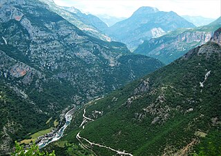
WThe Drin Valley is a valley in northern and eastern Albania along the Drin River.
 W
WDukagjin highlands is a mountainous region in northern Albania, east of Shkodra and north of the Drin. It is roughly equivalent to the northern half of the Shkodër District, with some minor parts in Malësi e Madhe District.
 W
WThe Fan is a river in northern Albania. It is formed by the confluence of two source rivers: the Great Fan and the Little Fan, that join a few kilometers west of the town Rrëshen.
 W
WFranz Joseph Island is an island located at the mouth of the Buna River in Albania. The island is made up of rich alluvial soil and becomes a peninsula depending on the size of the river's flow. This island is an important nesting ground for many seabirds, especially the family Ardeidae.
 W
WThe Kir is a river in northern Albania that first flows south-southwest and then southwest out of the North Albanian Alps and enters a distributary of the Drin just below Shkodër.
 W
WThe Lagoon of Viluni, also commonly Lagoon of Velipojë, is a lagoon of the Adriatic Sea on the Mediterranean Sea in the northern coast of Albania. Throughout history, the lagoon was a sea inlet and has been currently transformed into an estuary formed through a channel from the Buna River.
 W
WLake Koman is a reservoir on the Drin River in northern Albania. Lake Koman is surrounded by dense forested hills, vertical slopes, deep gorges, and a narrow valley, completely taken up by the river. Besides the Drin, it is fed by the Shala and Valbona Rivers. The lake stretches in an area of 34 km2 (13 sq mi), its width being 400 m (0.25 mi). The narrowest gorge, which is surrounded by vertical canyon walls, is more than 50 m (0.031 mi) wide. The reservoir was constructed between 1979 and 1988 near the village of Koman with a height of 115 m (377 ft).
 W
WThe Lake Shkodër Nature Reserve is a nature reserve in northwestern Albania.
 W
WMalësi e Madhe District, commonly known as Malësia, was one of the thirty-six districts of Albania. It had a population of 36,770 in 2001, and an area of 897 km². It is in the north of the country, and its capital was Koplik. Its territory is now part of Shkodër County, and is coterminous with the present municipality of Malësi e Madhe.
 W
WMunella is a mountain peak in Shkodër, Lezhë Albania.
 W
WThe Nikaj-Mërtur Regional Nature Park is a regional nature park in northern Albania, strategically inside the southeastern Albanian Alps in Tropojë. It lies within the area of the historical Nikaj-Mërturi region. The park is an area of alpine landscapes, deep valleys, vertical cliffs, dense coniferous and deciduous forests, small lakes and rivers. The International Union for Conservation of Nature (IUCN) has listed the park as Category IV. Like most of the Albanian Alps, it is listed as an important Plant Area, because it supports significant plant species.
 W
WPukë District was one of the thirty-six districts of Albania. It had a population of 34,454 in 2001, and an area of 1,034 km². It is located in the north of the country and its capital was Pukë. Its territory is now part of Shkodër County: the municipalities of Fushë-Arrëz and Pukë.
WThe Shalë is a river flowing inside the Albanian Alps in northern Albania. Its source is in the Albanian Alps, near the village Theth, close to the border with Montenegro. The Shalë flows generally south through the municipal units Shalë, Shosh and Temal. It flows into the Koman Reservoir, fed and drained by the river Drin, near the village Telum.
 W
WShkodër District was one of the thirty-six districts of Albania. It had a population of 185,794 in 2001, and an area of 1,631 km². It is in the north of the country, and its capital was Shkodër. Its territory is now part of Shkodër County: the municipalities of Shkodër and Vau i Dejës.
 W
WThe Theth National Park is a national park in northern Albania. Established in 1966, the park covers 2,630 ha (26.3 km2) and is centred on the Albanian Alps, encompassing the larger portion of Shala Valley. The park was established to protect various ecosystems and biodiversity and the cultural and historical heritage of the region. It is dominated by high terrain, with a wide variety of natural features including valleys, rivers, mountains, waterfalls, dense forests and several rock formations. The International Union for Conservation of Nature (IUCN) has listed the park as Category II. Notably, the region has been also identified as an important Bird and Plant Area. In 2017, Theth has been further declared a Protected Historic Center.
 W
WZadrima is a region in the district of Shkodër and Lezhë, Albania. It is mostly located in the Zadrima Plain. The region was part of the Principality of Dukagjini in the 15th century.