 W
WVolcán Atitlán is a large, conical, active stratovolcano adjacent to the caldera of Lake Atitlán in the Guatemalan Highlands of the Sierra Madre de Chiapas range. It is within the Sololá Department, southwestern Guatemala.
 W
WVolcán Chingo is a stratovolcano on the border between Guatemala and El Salvador.
 W
WThe Chocón Machacas Protected Biotope is a protected nature reserve in eastern Guatemala. It is located in the municipality of Livingston, in a densely forested area covering the lower reaches of the Chocón Machacas River basin and the northern shores of the Río Dulce-Golfete Dulce system.
 W
WGrutas de Lanquín is a large limestone cave system located 1 kilometre (0.62 mi) west of Lanquín in Alta Verapaz, Guatemala.
 W
WVolcán Ipala is a stratovolcano in south-eastern Guatemala. It has a 1,000 metres (3,300 ft) wide summit crater which contains a crater lake, whose surface lies about 150 m (500 ft) below the crater rim. Volcán Ipala is part of a cluster of small stratovolcanoes and cinder cone fields in south-eastern Guatemala.
 W
WVolcán Ixtepeque is a stratovolcano in southern Guatemala. It consists of several rhyolitic lava domes and basaltic cinder cones. Its name is derived from the nahuatl word for obsidian. Ixtepeque was one of the most important obsidian sources in pre-Columbian Mesoamerica.
 W
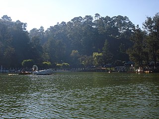
WLos Aposentos is a small forested park area with a number of springs and two small lakes. It is located a few kilometers south of the city of Chimaltenango in Guatemala. It was formerly known as "Finca la Alameda" and renamed to Los Aposentos in 1929.
 W
WManchón Guamuchal is a litoral wetland zone situated along the Pacific coast of Guatemala. It is one of the last remaining mangrove forest area on the pacific coast of Guatemala and an important stop for migratory birds. It was declared a Ramsar site in 1995.
 W
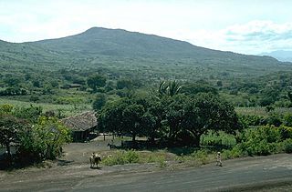
WMoyuta is a stratovolcano in southern Guatemala. It is located near the town of Moyuta in Santa Rosa Department, and is situated at the southern edge of the Jaltapagua fault. The volcano has an elevation of 1662 m and its summit is formed by three andesitic lava domes. The slopes of the volcano complex have numerous cinder cones. Small fumaroles can be seen on the northern and southern slopes, and hot springs are found at the north-eastern base of the volcano, as well as along rivers on south-eastern side. The volcano is covered with forest and coffee plantations.
 W
WPayne's Creek National Park is a nature reserve in the Toledo District of southern Belize. The park encompasses 37,680 acres (152 km2) of land including the dominant broadleaf forest as well as mangrove areas.
 W
WPunta Izopo National Park is a national park located in the municipality of Tela, on the northern Caribbean coast of the Atlántida department of Honduras. It has an altitude of 118 metres.
 W
WVolcán San Pedro is a 3,020-metre (9,908 ft) stratovolcano on the shores of Lago de Atitlán, in the Sololá Department of southern Guatemala.
 W
WVolcán Santo Tomás is a stratovolcano in southern Guatemala. It is also known as "Volcán Pecul", or as "Cerro Zunil" the name of its youngest and most prominent dome which was last active approximately 84,000 years ago.
 W
WSemuc Champey is a natural monument in the department of Alta Verapaz, Guatemala, near the Q'eqchi' Maya town of Lanquín. It consists of a natural 300 m limestone bridge, under which passes the Cahabón River. Atop the bridge is a series of stepped, turquoise pools, a popular swimming attraction.
WThe Sierra del Lacandón is a low karstic mountain range in Guatemala and Mexico. It is situated in the north-west of the department of El Petén and the south-east of Chiapas. Its highest points are located near the Mexican border at coordinates 17.244195°N 91.202145°W and 17.195087°N 91.086102°W The range consists of southeast to northwest trending ridges of folded Cretaceous limestone and dolomite hills rising above the lowlands of the Petén Basin.
 W
WVolcán Suchitán is a stratovolcano located in Asunción Mita, Jutiapa, Guatemala.
 W
WTahual is a stratovolcano in southern Guatemala.
 W
WTecuamburro is a stratovolcano in southern Guatemala, roughly 50 kilometres south east of Guatemala City. The Tecuamburro is an andesitic stratovolcano which formed approximately 38,000 years ago inside a horseshoe-shaped caldera formed by a structural failure in a second, 100,000-year-old stratovolcano, known as Miraflores. At the top of the Tecuamburro is an acidic crater lake around which many hot springs, fumaroles, and boiling mudpots are found.
 W
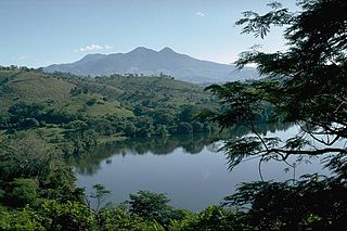
WTolimán is a stratovolcano in Guatemala, on the southern shores of Lake Atitlán. The volcano has an elevation of 3,158 m and was formed near the southern margin of the Pleistocene Atitlán III caldera. The top of the volcano has a shallow crater and its flanks are covered with the thick remains of ancient lava flows that emerged from vents in the volcano's flanks.