 W
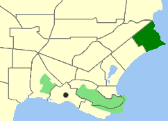
WBayonet Head is an outer north-eastern suburb of Albany, Western Australia, on the west bank of Oyster Harbour. Its local government area is the City of Albany. Until the 1980s, it was known as Flinders Park.
 W
WCentennial Park is an inner suburb of Albany, Western Australia, immediately north of the CBD within the local government area of the City of Albany. It contains a light industrial area and numerous sporting facilities which serve the entire Albany catchment area.
 W
WCollingwood Heights is a north-eastern suburb of Albany, Western Australia, between the Albany city centre and Emu Point within the local government area of the City of Albany.
 W
WCollingwood Park is a north-eastern suburb of Albany, Western Australia, just west of the Emu Point holiday resort along King George Sound on the west bank of Oyster Harbour. Its local government area is the City of Albany.
 W
WEmu Point is a north-eastern suburb of Albany in southern Western Australia north-east of Albany's central business district. Its local government area is the City of Albany.
 W
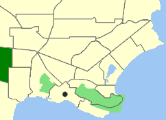
WGledhow is a western suburb of Albany in southern Western Australia. Its local government area is the City of Albany. The suburb has a median age of 38.
 W
WLange is a northern suburb of Albany in southern Western Australia, north of Albany's central business district. Its local government area is the City of Albany. The population of the suburb has a median age of 39 years.
 W
WLittle Grove is a suburb of Albany, Western Australia.
 W
WLockyer is a north-western suburb of Albany in southern Western Australia. Its local government area is the City of Albany. The suburb has a median age of 33, and was officially named in 1954.
 W
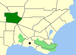
WMcKail is a north-western suburb of Albany in southern Western Australia. Its local government area is the City of Albany. The suburb has a median age of 33. McKail was named after John MacKail who in 1835 wrongly killed Whadjuk Noongar Goggalee and was forced to leave the Swan River settlement.
 W
WMiddleton Beach is a coastal suburb of Albany, Western Australia, located within the City of Albany approximately 4 kilometres (2.5 mi) east of the city centre. The traditional owners, the Noongar peoples, know the place as Binalup meaning the place of first light since the sun rises over the waters in the morning. The main road between the city and the locality is via Middleton Road. It is home to a caravan park and numerous holiday units which provide accommodation for visitors to the Albany region.
 W
WMilpara is a north-western suburb of Albany in southern Western Australia. Its local government area is the City of Albany.
 W
WMira Mar is a northeastern suburb of Albany, Western Australia, between the Albany city centre and Spencer Park in the local government area of the City of Albany.
 W
WMount Clarence is an inner suburb of Albany, Western Australia, between the Albany city centre and Middleton Beach. Its local government area is the City of Albany, and over three-quarters of its land area is either parkland or forest, including Albany's Heritage Park. Mount Clarence was gazetted as a suburb in 1979.
 W
WMount Melville is a south-western suburb of Albany in southern Western Australia, west of Albany's central business district. Its local government area is the City of Albany.
 W
WOrana is a north-western suburb of Albany in southern Western Australia, northwest of Albany's central business district. Its local government area is the City of Albany.
 W
WRobinson is a western suburb of Albany in southern Western Australia, west of Albany's central business district. Its local government area is the City of Albany. The suburb has a median age of 43.
 W
WSpencer Park is a north-eastern suburb of Albany in southern Western Australia north-northeast of Albany's central business district. Its local government area is the City of Albany, and the suburb was gazetted in 1954.
 W
WYakamia is an inner suburb of Albany. The suburb was created in the 1970s, and was gazetted in 1979. The name is believed to be a Noongar word meaning "sister to a small creek".