 W
WAdwa is a stratovolcano in Ethiopia, located in the southern Afar region and has a 4 by 5 km caldera. Due to the location of the volcano near the boundary between Afar and Issa tribes, little is known about the past and present behavior of the volcano. However, an earthquake and InSAR study conducted by Derek Keir and colleagues shows that a magma intrusion around 5 km deep and 8 km long emanated away from the eastern side of the volcano in May 2000.
 W
WLake Afambo is one of a chain of lakes into which the Awash River empties its waters. It is located at the eastern end of the Afar Region of Ethiopia.
 W
WAfdera is an isolated stratovolcano in northeastern Ethiopia, located at the intersection of three fault systems between the Erta Ale, Tat Ali, and Alayta mountain ranges.
WMount Alayta is an active shield volcano in the Afar Region of Ethiopia. Part of the Afar Triangle, a highly active volcanic region which includes the adjacent Mount Afdera, this volcano covers an area of 2700 square kilometers southwest of Lake Afrera. A chain of younger craters are aligned along a north-northwest axis in the basaltic-to-trachytic shield along the east side of the shield volcano, which extends to the western flank of Mount Afdera. The Alayta Lavafeld covered by fresh lava streams was formed from a series of north-south fissures. In two areas on the southern side of the volcanic complex, fumaroles can be observed.
 W
WAle Bagu is a stratovolcano located in the Afar Region, Ethiopia. It is the highest volcano of Erta Ale Range. The village of El Dom sits at the base of Ale Bagu.
 W
WAwash National Park is a national park in Ethiopia. Spanning across the southern tip of the Afar Region and the northeastern corner of the Misraq Shewa Zone of Oromia, this park is 225 kilometers east of Addis Ababa, with its southern boundary along the Awash River, and covers 756 square kilometers of acacia woodland and grassland. The Addis Ababa - Dire Dawa highway passes through this park, separating the Illala Saha Plains to the south from the Kudu Valley to the north. In the south of the park the Awash River gorge has amazing waterfalls. In the upper Kudu Valley at Filwoha are hot springs amid groves of palm trees.
WMount Ayalu is an isolated, rhyolitic stratovolcano in eastern Ethiopia. Located in Administrative Zone 3 of the Afar Region, near the eastern bank of the Awash River, this mountain has a latitude and longitude of 10°5′N 40°42′E and an altitude of 2145 meters.
WLake Bario is one of a chain of lakes into which the Awash River empties its waters. It is located at the eastern end of the Afar Region of Ethiopia. Lake Bario lies in the middle of a swamp, through which it receives its inflow from Lake Afambo to the northeast. Its outflow is on its southern side, which circles around Mount Dama Ali to empty into Lake Abbe.
 W
WBerhale is a town in north-eastern Ethiopia. Located in the Administrative Zone 2 of the Afar Region, this town has a latitude and longitude of 13°51′N 40°01′E with an altitude of 639 meters above sea level. It is the largest town in Berhale woreda.
 W
WThe Bidu woreda is one of the woredas in the Afar Region of Ethiopia, it forms part of the Administrative Zone 2.
WBorale Ale is a stratovolcano located in the Great Rift Valley, Ethiopia.
 W
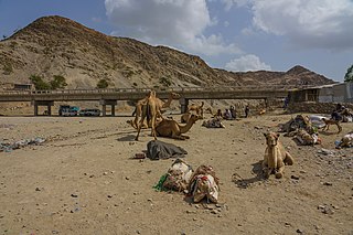
WBure is a small area about 80 kilometres (50 mi) west of Asseb, on the border between Eritrea and Ethiopia, and claimed by both countries. Bure lies across the important Awash-Asseb highway, which in the past has been an important trucking route.
 W
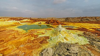
WDallol is a cinder cone volcano in the Danakil Depression, northeast of the Erta Ale Range in Ethiopia. It was formed by the intrusion of basaltic magma into Miocene salt deposits and subsequent hydrothermal activity. Phreatic eruptions took place here in 1926, forming Dallol Volcano; numerous other eruption craters dot the salt flats nearby. These craters are the lowest known subaerial volcanic vents in the world, at 45 m (150 ft) or more below sea level. In October 2004 the shallow magma chamber beneath Dallol deflated and fed a magma intrusion southwards beneath the rift. A phreatic eruption occurred in January 2011.
 W
WErebti is one of the woredas in the Afar Region of Ethiopia. It is named after the Erebti River, a stream that flows east from the Ethiopian highlands into the Afar Depression, part of which lies in the eastern part of this woreda. One of the woredas in the Administrative Zone 2, Erebti is bordered on the south by the Administrative Zone 4, on the southwest by Megale, on the northwest by Abala, and on the north and east by Afdera. The major town in this woreda is Erebti; other settlements include Doxom and Lakora.
 W
WErta Ale Range is the most important axial volcanic chain of the Afar Depression, Afar Region, Ethiopia. It consists mostly of shield volcanoes. The active volcano Erta Ale is a prominent feature of the range. The highest volcano of the range is Ale Bagu, with an elevation of 1,031 m (3,383 ft) above sea level.
WLake Gummare is one of a chain of lakes into which the Awash River empties its waters. It is located at the eastern end of the Afar Region of Ethiopia.
 W
WLake Karum is a salt lake in the Afar Region of Ethiopia. One of two salt lakes in the northern end of the Danakil Depression, it lies at −120 m (−394 ft) relative to sea level. The volcano Erta Ale rises southwest of this lake.
WMeteka is a town in north-eastern Ethiopia. Located in Administrative Zone 3 of the Afar Region, 30 kilometers south of Gewane, it has a latitude and longitude of 9°52′N 40°31′E with an elevation of 628 meters above sea level. It is one of two towns in Gewane woreda.
 W
WWollo is a historical region and province in the northeastern part of Ethiopia, with its capital city at Dessie. The name "Wello" represents the Wello Oromo clan.
WYangudi Rassa National Park is a national park in Ethiopia located in the Afar Region, its 4730 square kilometers of territory include Mount Yangudi near the southern border and the surrounding Rassa Plains, with altitudes from 400 to 1459 meters above sea level. Sandy semi-desert and wooded grassland cover the majority of the park's area. This park lies between the territory of the Afars and the Issas, and while violence have been frequent between them, most of the park is in an area where they avoid each other. As a result, most of the active protection of the park is focused on managing their conflict.