 W
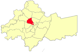
WAbdali is an area in the Greater Amman Municipality, it is named relative to King Abdullah I who founded it during the 1940s. It covers an area of 15 square kilometres (6 sq mi) in the heart of Amman, with a population of 165,333 in 2015. Large parts of the district are residential, but due its geographical location in the center of the city, it contains several important governmental buildings and businesses. The area is known for containing several bus stations serving routes to many cities in Jordan.
 W
WAbu Nseir is one of the areas of the Greater Amman Municipality, Jordan.
 W
WBader is one of the areas of the Greater Amman Municipality, Jordan.
 W
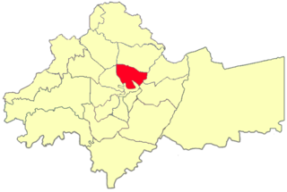
WBasman is a district of the city of Amman, Jordan.
 W
WJubaiha is an area number 18 out of 27. Located in western Amman, Jordan. It is divided into seven neighborhoods, Al-Jam'a, Al-Rasheed, Qutneh, Al-Sadeeq, Al-Zaytooneh, and Al-Baladiya.
 W
WAl-Madinah is one of the areas of the Greater Amman Municipality, Jordan.
 W
WMarj Al-Hamam is the district number 27 of Metropolitan Amman – Greater Amman Municipality (GAM); it is situated to the western part of GAM. It comprises 16 neighborhoods and population gatherings ; it is 53 Km2 of space; its population counts for 82788 capita. Its zoning borders include Naour, Mqabalein, and Wadi EsSeer. Since 2007, it has been part of the Greater Amman Municipality.
 W
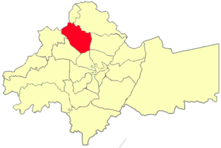
WMarka is an area of Greater Amman Municipality, Jordan. It is to the north-east of Amman proper. Its confines include Amman Civil Airport and the Marka refugee camp. Population as of 2015 was 148,100.
 W
WAl-Muwaqqar is a district in the Amman Governorate of north-western Jordan. The village contains the scant ruins of an Umayyad palace, the Qasr al-Muwaqqar, one of the desert castles. Little remains of the palace today except several acanthus leaf capitals and gauge of a water reservoir.
 W
WNaour, also called Naur, is region number 26 in the Greater Amman Municipality. It is located on the west side of the capital, and comprises 26 neighborhoods or residential areas. Naour comprises approximately 87 km2, i.e., 5.19%, of the total landscape of Greater Amman Municipality. Its population is 50,000 and it is bordered by six regions.
 W
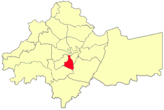
WAl-Nasr is one of the areas of the Greater Amman Municipality, Jordan.
 W
WRas al-Ein is one of the 22 administrative sub-districts of the city of Amman, Jordan, as governed by the Greater Amman Municipality.
 W
WSahab is a municipality in Jordan located 16 kilometers (9.9 mi) southeast of the capital Amman. It is the only locality in the Sahab District of the Amman Governorate. Modern Sahab began as a Bedouin-owned plantation village in the late 19th century during Ottoman rule. The plantation was originally worked by Egyptian migrant farmers who purchased and permanently settled the lands in 1894 and developed Sahab into an agricultural estate. Sahab became its own municipality in 1962 and today is a densely populated industrial hub. It is home to the country's largest industrial city, the Abdullah II Ibn Al-Hussein Industrial Estate, and the largest cemetery in greater Amman, as well as the Caves of Raqeem site mentioned in the Qur'an. The population of Sahab in 2015 was 169,434.
 W
WShafa Badran is one of the areas of the Greater Amman Municipality, Jordan.
 W
WSweileh is district number sixteen in Amman, Jordan out of twenty-seven. It lies to the north of the city center. It was founded by Chechen settlers in 1906 during Ottoman rule. It had a population of 151,016 in the 2015 census. The town is known for having a good climate throughout the year, it is one of the few districts of Amman that sees snow during winter due to its high altitude. The cultivation of olives and grapes, heavy industries, such as auto assembly, steel, and cement, make up the local economy. Today, it is considered one of Amman's most populated districts since it has the University of Jordan and is a connection point to other cities such as Salt, Irbid and Jarash.
 W
WTariq is an area of the Greater Amman Municipality, Jordan. Population was 175,194 as of 2015.
 W
WTla' Al-Ali is one of the districts of Amman governorate, Jordan.
 W
WWadi Al-Seer or Wadi as-Seer is an area in the Greater Amman Municipality named after a prehistoric queen that ruled the area, Queen Seer. It consists of ten neighborhoods, some of which are residential, other commercial, or both.
 W
WAl-Yarmouk is one of the areas of the Greater Amman Municipality, Jordan.
 W
WZahran is an area in the Greater Amman Municipality. It is named after the Zahran Palace which stands amidst Zahran street. It consists of 5 neighborhoods of which most parts are residential, however, some parts of the district contain Amman's best hotels, hospitals and towers. The district is also home to several governmental buildings, embassies, cultural centers and schools. Zahran area stretches from 1st circle to between 5th and 6th circles, and from North Abdoun to South Abdoun.