 W
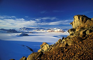
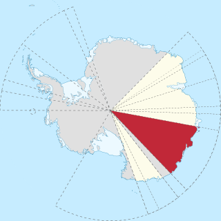
WEast Antarctica, also called Greater Antarctica, constitutes the majority (two-thirds) of the Antarctic continent, lying on the Indian Ocean side of the continent, separated from West Antarctica by the Transantarctic Mountains. It lies almost entirely within the Eastern Hemisphere and its name has been accepted for more than a century. It is generally higher than West Antarctica and includes the Gamburtsev Mountain Range in the centre.
 W
WAn Antarctic oasis is a large area naturally free of snow and ice in the otherwise ice-covered continent of Antarctica.
 W
WThe Antarctic Plateau, Polar Plateau or King Haakon VII Plateau, is a large area of East Antarctica which extends over a diameter of about 1,000 kilometres (620 mi), and includes the region of the geographic South Pole and the Amundsen–Scott South Pole Station. This huge continental plateau is at an average elevation of about 3,000 metres (9,800 ft) high.
 W
WDome A or Dome Argus is the loftiest ice dome on the Antarctic Plateau, located 1,200 kilometres (750 mi) inland. It is thought to be the coldest naturally occurring place on Earth; with temperatures believed to reach −90 °C (−130 °F) to −98 °C (−144 °F). It is the highest ice feature in Antarctica, consisting of an ice dome or eminence of 4,093 metres' (13,428 ft) elevation above sea level. It is located near the center of East Antarctica, approximately midway between the enormous head of Lambert Glacier and the geographic South Pole, within the Australian claim.
 W
WThe East Antarctic Ice Sheet (EAIS) is one of two large ice sheets in Antarctica, and the largest on the entire planet. The EAIS lies between 45° west and 168° east longitudinally.
 W
WThe East Antarctic Shield or Craton is a cratonic rock body that covers 10.2 million square kilometers or roughly 73% of the continent of Antarctica. The shield is almost entirely buried by the East Antarctic Ice Sheet that has an average thickness of 2200 meters but reaches up to 4700 meters in some locations. East Antarctica is separated from West Antarctica by the 100–300 kilometer wide Transantarctic Mountains, which span nearly 3,500 kilometers from the Weddell Sea to the Ross Sea. The East Antarctic Shield is then divided into an extensive central craton that occupies most of the continental interior and various other marginal cratons that are exposed along the coast.
WKing Haakon VII Sea is a proposed name for part of the Southern Ocean on the coast of East Antarctica.
 W
WMount Kjerringa is an isolated peak, 1,220 metres (4,000 ft) above sea level, situated roughly 8 nmi (15 km) north of the Aker Peaks, 26 nmi (48 km) west of Magnet Bay, and 57 km (31 nmi) northeast of Mount Elkins in Enderby Land, East Antarctica.
 W
WMac. Robertson Land is the portion of Antarctica lying southward of the coast between William Scoresby Bay and Cape Darnley. It is located at 70°00′S 65°00′E. In the east, Mac. Robertson Land includes the Prince Charles Mountains. It was named by the British Australian and New Zealand Antarctic Research Expedition (BANZARE) (1929-1931), under Sir Douglas Mawson, after Sir Macpherson Robertson of Melbourne, a patron of the expedition.
 W
WThe Mawson Station, commonly called Mawson, is one of three permanent bases and research outposts in Antarctica managed by the Australian Antarctic Division (AAD). Mawson lies in Holme Bay in Mac Robertson Land, East Antarctica in the Australian Antarctic Territory, a territory claimed by Australia. Established in 1954, Mawson is Australia's oldest Antarctic station and the oldest continuously inhabited Antarctic station south of the Antarctic Circle.
 W
WMid Point is a skiway located in the East Antarctic Ice Sheet at midway between Zucchelli Station and the inland Concordia Station. Mid Point Airstrip, being at 530 kilometres (330 mi) from Zucchelli, is a refuelling place for the aircraft on their way to Concordia. The place is equipped with shelters, meteorological equipment, fuel bladders and tractors to clean the airstrip. An American researchers team lived at the camp for a time, in 2000, to carry out a project of ice drilling.
 W
WMolodyozhnaya was a Soviet, then Russian research station in East Antarctica at 67°40′S 45°50′E. After being mothballed in 1990, it was reopened in 2006 to operate on a seasonal basis. In Russian, the station is sometimes referred to as the capital of Antarctica.
 W
WSitry Airstrip, the name is derived from the abbreviation of C-3, was an Antarctic skiway operated by the Italian ENEA-Unità Tecnica Antartitide as part of the National Antarctic Research Program (PNRA).
 W
WThe South Magnetic Pole is the point on Earth's Southern Hemisphere where the geomagnetic field lines are directed vertically upwards. The Geomagnetic South Pole, a related point, is the south pole of an ideal dipole model of the Earth's magnetic field that most closely fits the Earth's actual magnetic field.
WThe South Magnetic Pole is the point on Earth's Southern Hemisphere where the geomagnetic field lines are directed vertically upwards. The Geomagnetic South Pole, a related point, is the south pole of an ideal dipole model of the Earth's magnetic field that most closely fits the Earth's actual magnetic field.
 W
WThe South Pole, also known as the Geographic South Pole or Terrestrial South Pole, is one of the two points where Earth's axis of rotation intersects its surface. It is the southernmost point on the surface of Earth and lies on the opposite side of Earth from the North Pole.
 W
WThe Soviet Plateau is the highest part of the glacial cover of East Antarctica, located within 75–84° south latitude and 25–105° east longitude. According to the Atlas of the Antarctic, the central point of the Soviet plateau has coordinates 80°0′S 85°00′E.
 W
WThe Transantarctic Mountains comprise a mountain range of uplifted rock in Antarctica which extend, with some interruptions, across the continent from Cape Adare in northern Victoria Land to Coats Land. These mountains divide East Antarctica and West Antarctica. They include a number of separately named mountain groups, which are often again subdivided into smaller ranges.
 W
WVictoria Land is a region of Antarctica which fronts the western side of the Ross Sea and the Ross Ice Shelf, extending southward from about 70°30'S to 78°00'S, and westward from the Ross Sea to the edge of the Antarctic Plateau. It was discovered by Captain James Clark Ross in January 1841 and named after the UK's Queen Victoria. The rocky promontory of Minna Bluff is often regarded as the southernmost point of Victoria Land, and separates the Scott Coast to the north from the Hillary Coast of the Ross Dependency to the south.
 W
WWilkes Land is a large district of land in eastern Antarctica, formally claimed by Australia as part of the Australian Antarctic Territory, though the validity of this claim has been placed for the period of the operation of the Antarctic Treaty, to which Australia is a signatory.