 W
WAkatarawa Forest is a regional park in the Upper Hutt within the Wellington Region at the southern tip of the North Island of New Zealand. It encompasses 15,000 hectares of native and plantation forest. It includes the headwaters of the Maungakotukutuku Steam, Akatarawa River West and the Whakatikei River.
 W
WBarton's Bush, in Trentham Memorial Park, is the largest remaining area of lowland mixed podocarp/broadleaf forest in the Hutt Valley of New Zealand. Named after Richard Barton who settled in the area in 1841, it was his desire that this section of the native forest should remain whilst the city of Upper Hutt gradually took shape and land was cleared for farming and settling.
 W
WBerwick Forest is a large Pinus radiata (Pine) plantation at Berwick in New Zealand, around 40 km west of Dunedin. The forest lies close to the banks of the Waipori River immediately below and around the western end of Lake Mahinerangi, and consists of three blocks - the main block, Maungatua, and Waitahuna, with a total area of 13,141 hectares. The land is owned by Otago Land Company, a sub company of Boston-based investment company GMO LLC, the trees by Wenita Forest Products, which has shareholders Sinotrans (62%), the Chinese shipping company, and GMO.
 W
WBethune's Gully is notable geological feature of northern Dunedin, in the South Island of New Zealand. It is located close to the suburb of Normanby towards the northern end of North East Valley. It preserves a number of acres of very old-growth forest and a large stand of exotic Douglas fir, and is an ecosystem directly below the cloud forest on the upper slopes of Mount Cargill. The gully was formed by the upper reaches of Lindsay Creek, a tributary of the Water of Leith which flows along North East Valley.
 W
WBottle Lake Forest is a production forest and recreational park located in Christchurch, New Zealand, approximately 10 kilometres (6.2 mi) north-east of the city centre. It makes up the vast majority of the area of the suburb Bottle Lake. The visitor centre at the Forest's entry from Waitikiri Drive provides visitors with information about the different roles of Bottle Lake Forest. It also provides fresh water access, toilet facilities and parking.
 W
WBushy Park is a forest located on the west coast of the North Island of New Zealand, at 791 Rangitatau East Road, 8 kilometres (5.0 mi) from Kai Iwi, Whanganui, Manawatū-Whanganui region. It features an Edwardian-era homestead, Bushy Park Homestead, which is a Category I heritage building registered with Heritage New Zealand, a predator-free native bird sanctuary, and a virgin rainforest. It measures approximately 100 hectares, and is characterized as a "lowland remnant of rata-podocarp taka-puketea [sic] rainforest". According to Forest & Bird, Bushy Park is considered to be amongst the 25 best restoration ecology projects in Australia and New Zealand.
 W
WThe Catlins comprises an area in the southeastern corner of the South Island of New Zealand. The area lies between Balclutha and Invercargill, straddling the boundary between the Otago and Southland regions. It includes the South Island's southernmost point, Slope Point.
 W
WKaingaroa Forest covers 2900 km² of the Bay of Plenty region of New Zealand, and is the largest forest plantation in New Zealand, and the second largest in the Southern Hemisphere. The forest stretches from Lake Taupo in the south to Kawerau to the north. The headquarters of the forest are at the small settlement of Kaingaroa, 50 kilometres southeast of Rotorua. Prior to planting the area was a tussock and scrub plateau, formed on volcanic ash.
 W
WThe Nelson Coast temperate forests is an ecoregion in New Zealand.
The New Zealand Forest Service was originally established in 1919 as the State Forest Service. The State Forest Service changed its name to the New Zealand Forest Service in 1949, at about the same time that the Forests Act of 1949 passed through Parliament.
 W
WThe Northland temperate forests, also known as the North Island temperate forests, is a temperate broadleaf and mixed forests ecoregion on New Zealand’s North Island.
 W
WThe Northland temperate kauri forests is an ecoregion in northern New Zealand, within the temperate broadleaf and mixed forests biome.
 W
WRedwoods Forest is a forest of naturalised coastal redwood on the outskirts of Rotorua, New Zealand, adjacent to the Whakarewarewa thermal area. The 6 hectares stand of Californian Redwoods is part of the larger Whakarewarewa State Forest.
 W
WThe Richmond temperate forests is an ecoregion covering the northern part of New Zealand's South Island.
 W
WThe Seventy Mile Bush was a heavily forested area of New Zealand extending from Wairarapa to Central Hawkes Bay and out to that coast. It was cleared and settled by Scandinavians, assisted immigrants in the 1870s. On arrival they walked from the surrounding coastal settlements to cut down the forest and clear the land for farming. The land was not as described to them. Without funds for a return passage they were obliged to remain.
 W
WThe Southland temperate forests is a temperate broadleaf and mixed forests ecoregion on New Zealand's South Island. The natural vegetation was mostly forest, but over the centuries human activities, including grazing and fires, replaced much of the original forest with grassland and agriculture.
 W
WThe Square Kauri is an estimated 1,200 year old kauri tree in the Coromandel Range on the Coromandel Peninsula, New Zealand. It is the 15th largest kauri on the peninsula
 W
WTāne Mahuta, also called God of the Forest, is a giant kauri tree in the Waipoua Forest of Northland Region, New Zealand. Its age is unknown but is estimated to be between 1,250 and 2,500 years. It is the largest kauri known to stand today. It is named for the Māori god of forests and of birds.
 W
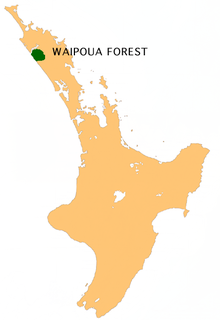
WWaipoua Forest is a forest, on the west coast of the Northland Region of New Zealand's North Island. It preserves some of the best examples of kauri forest remaining in New Zealand. It is notable for having two of the largest living kauri trees, Tāne Mahuta and Te Matua Ngahere.
 W
WThe Westland temperate forests, also known as the Westland temperate rainforests, is a temperate broadleaf and mixed forests ecoregion located along the central west coast of New Zealand’s South Island, also known as Te Waipounamou. These forests are found in the region of the Westland District, which spans approximately 11,880 square kilometers. It is bounded on the west by the Tasman Sea, and on the east by the Southern Alps. Much of this area is protected by the Westland Tai Poutini National Park.