 W
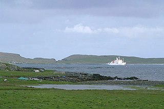
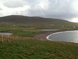
WBalta Sound is a sound (inlet) on the east coast of the island of Unst in the Shetland Islands, Scotland. The sound is sheltered from the North Sea to the east by the uninhabited island of Balta.
 W
WBluemull Sound is the strait between Unst and Yell in Shetland's North Isles. A ferry service crosses it regularly. Cullivoe is on the Yell side, and the island of Linga lies in the strait.
 W
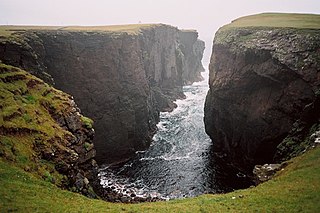
WCalders Geo is an inlet in the western cliffs of Esha Ness in Northmavine on the Mainland, Shetland, Scotland. A cave on the north side of the geo has been measured at more than one and a half times the size of "The Frozen Deep", a chamber in Reservoir Hole under Cheddar Gorge in Somerset, potentially making it the largest natural chamber in Britain.
 W
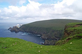
WEsha Ness, also spelled Eshaness, is a peninsula on the west coast of Northmavine, on the island of Mainland, Shetland, Scotland. Esha Ness Lighthouse on the west coast, just south of Calder's Geo. It was designed by David Alan Stevenson and commissioned in 1929. The hamlet of Tangwick contains the Tangwick Haa Museum, which opened in the former Laird's house in 1987.
WA geo or gio is an inlet, a gully or a narrow and deep cleft in the face of a cliff. Geos are common on the coastline of the Shetland and Orkney islands. They are created by the wave driven erosion of cliffs along faults and bedding planes in the rock. Geos may have sea caves at their heads. Such sea caves may collapse, extending the geo, or leaving depressions inland from the geo. Geos can also be created from this process.
 W
WHamars Ness is a headland on the island of Fetlar in Shetland, Scotland. The name is from the Old Norse Hamarsnes meaning "craggy headland". A ro-ro ferry is operated from here, which links Fetlar to the Shetland Mainland, and to the island of Unst. Hamars Ness is to the north of Fetlar's main village of Houbie.
 W
WHermaness is the northernmost headland of Unst, the most northerly inhabited island of Shetland, Scotland. It consists of huge sea cliffs and moorland, making it an ideal habitat for a variety of birds. Hermaness was designated a national nature reserve (NNR) in 1955. The NNR extends over 965 hectares, including the whole of the Hermaness peninsula and the outlying Muckle Flugga and Out Stack. The reserve has a path and boardwalk that extends out onto the moorland. The reserve is managed by NatureScot, though it remains in private ownership, with most being owned by the Buness Estate, although the stacks and skerries around Muckle Flugga are owned by the Northern Lighthouse Board.
 W
WLinga Sound is the strait between the islands of Whalsay and West Linga in the Shetland islands of Scotland.
 W
WLunna Ness is a peninsula in the north east of Mainland, Shetland, Scotland, in the parish of Lunnasting near Vidlin. The island of Lunna Holm is nearby. The Shetland Bus operation during World War II used this area as a base.
 W
WMavis Grind is a narrow isthmus joining the Northmavine peninsula to the rest of the island of Shetland Mainland in the Shetland Islands, Scotland. It is just 33 metres (108 ft) wide at its narrowest point.
 W
WThe Ness of Burgi is a narrow peninsula that stretches to the south from the Scat Ness headland of Mainland, Shetland, a Scottish island. It is in the parish of Dunrossness.
 W
WThe North Isles are the northern islands of the Shetland Islands, Scotland. The main islands in the group are Yell, Unst and Fetlar. Sometimes the islands in Yell Sound are included in this group.
 W
WThe Out Skerries are an archipelago of islets, some inhabited, in Shetland, Scotland, and are the easternmost group of Shetland's islands. Locally, they are usually called Da Skerries or just Skerries.
 W
WThe Pool of Virkie is a tidal lagoon in the parish of Dunrossness, south Mainland, Shetland.
 W
WSandness is a headland and district in the west of Shetland Mainland, Scotland. Sandness was a civil parish, which also included the island of Papa Stour some 1600 metres northwest across Papa Sound. In 1891, it was combined with Walls to the south, to form Walls and Sandness Parish, which had an administrative function until the abolition of Civil parishes in Scotland by the Local Government (Scotland) Act 1929, and had been a statistical regional unit since. Currently, the community council area of Sandness and Walls covers about the same area. The 1878 map of Sandness Parish shows that the parish to the east was Aithsting, before it was included into Sandsting to the south.
 W
WThe Scalloway Islands are in Shetland opposite Scalloway on south west of the Mainland. They form a mini-archipelago and include:Burra East Burra West Burra South Havra Little Havra Papa - belongs to Civil parish of Lerwick West Head of Papa (tidal)
 W
WSumburgh Head is located at the southern tip of the Shetland Mainland in northern Scotland. The head is a 100m high rocky spur capped by the Sumburgh Head Lighthouse. The Old Norse name was Dunrøstar høfdi, it means "The Head onto the loud tide-race", referring to the noise of Sumburgh Roost.
 W
WTingon is a peninsula in the north-west of Northmavine, Shetland. It is delineated on the east by Ronas Voe, and on the west by Hamnavoe. It is designated as a Ramsar site, a Special Protection Area, a Special Area of Conservation and a Site of Special Scientific Interest. It is also the collective name of a group of settlements on the peninsula, which were nearly all evicted as part of the Highland Clearances.
 W
WUyeasound is a village on the Isle of Unst, the northernmost island of the Shetland Islands, Scotland. It takes its name from the neighbouring strait of the same name, which looks over to the Isle of Uyea.
 W
WYell Sound is the strait running between Yell and Mainland, Shetland, Scotland. It is the boundary between the Mainland and the North Isles and it contains many small islands. Sullom Voe, on the shores of which is a substantial oil terminal, is an arm of Yell Sound.