 W
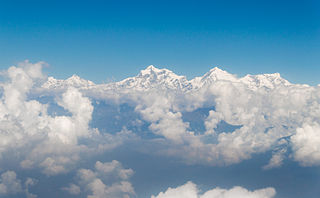
WThe Himalayas, or Himalaya, , is a mountain range in Asia separating the plains of the Indian subcontinent from the Tibetan Plateau. The range has many of Earth's highest peaks, including the highest, Mount Everest, at the border between Nepal and China. The Himalayas include over fifty mountains exceeding 7,200 m (23,600 ft) in elevation, including ten of the fourteen 8,000-metre peaks. By contrast, the highest peak outside Asia is 6,961 m (22,838 ft) tall.
 W
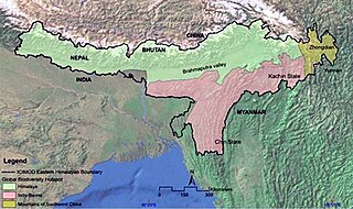
WThe Eastern Himalayas extend from eastern Nepal across Northeast India, Bhutan, the Tibet Autonomous Region to Yunnan in China and northern Myanmar. The climate of this region is influenced by the monsoon of South Asia from June to September. It is widely considered a biodiversity hotspot, with notable biocultural diversity.
 W
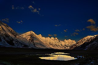
WWestern Himalaya refers to the western half of the Himalayas, stretching from Badakhshan in northeastern Afghanistan/southern Tajikistan, Pakistan through North India (Jammu and Kashmir, Ladakh and Himachal Pradesh.
 W
WThe Zaskar Range or Zanskar Range is a mountain range in the Indian regions of Jammu and Kashmir and Ladakh, that separates Zanskar from Ladakh. Geologically, the Zanskar Range is part of the Tethys Himalaya, an approximately 100-km-wide synclinorium formed by strongly folded and imbricated, weakly metamorphosed sedimentary series. The average height of the Zanskar Range is about 6,000 m (19,700 ft). Its eastern part is known as Rupshu. It belongs to the trans-Himalayas.
 W
WGanesh Himāl is a sub-range of the Himalayas located mostly in north-central Nepal, but some peaks lie on the border with Tibet. The Trisuli Gandaki valley on the east separates it from the Langtang Himal; the Budhi (Buri) Gandaki valley and the Shyar Khola valley on the west separate it from the Sringi Himal and the Mansiri Himal. The range lies about 70 km north-northwest of Kathmandu.
 W
WThe Garhwal Himalayas are mountain ranges located in the state of Uttarakhand, India. The mountain ranges cross two regions: Garhwal and Kumaon.
 W
WThe Gurans Himal is a small subrange of the Himalayas in far western Nepal. It is little-known, since it does not contain any 8000 metre peaks, or even any peaks above 7,200 metres. Its highest peak is Api, 7,132 m (23,399 ft), which, despite its relatively low height compared to the major Himalayan peaks, rises dramatically from a low base, as do the other significant peaks of the Gurans Himal.
 W
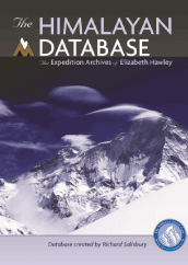
WThe Himalayan Database: The Expedition Archives of Elizabeth Hawley is a large digital and published record of mountaineering in the Nepalese Himalayas since 1903, maintained by Richard Salisbury who digitised the records.
 W
WThe Hindu Kush is an 800-kilometre-long (500 mi) mountain range that stretches through Afghanistan, from its centre to Northern Pakistan and into Tajikistan. The range forms the western section of the Hindu Kush Himalayan Region (HKH) and is the westernmost extension of the Pamir Mountains, the Karakoram and the Himalayas. It divides the valley of the Amu Darya to the north from the Indus River valley to the south. The range has numerous high snow-capped peaks, with the highest point being Tirich Mir or Terichmir at 7,708 metres (25,289 ft) in the Chitral District of Khyber Pakhtunkhwa, Pakistan. To the north, near its northeastern end, the Hindu Kush buttresses the Pamir Mountains near the point where the borders of China, Pakistan and Afghanistan meet, after which it runs southwest through Pakistan and into Afghanistan near their border. The eastern end of the Hindu Kush in the north merges with the Karakoram Range. Towards its southern end, it connects with the Spin Ghar Range near the Kabul River.
 W
WThe Hindu Raj is a mountain range in northern Pakistan, between the Hindu Kush and the Karakoram ranges. Its highest peak is Koyo Zom, 6,872 m (22,546 ft). Other notable peaks include Buni Zom, Ghamubar Zom and Gul Lasht Zom. The peaks in the Hindu Raj mountains reach around 5,000 feet to 6,000 feet on average.
 W
WThe Karakoram is a mountain range spanning the borders of China, India, and Pakistan, with the northwest extremity of the range extending to Afghanistan and Tajikistan; its highest 15 mountains are all based in Pakistan. It begins in the Wakhan Corridor (Afghanistan) in the west and encompasses the majority of Gilgit-Baltistan (Pakistan) and extends into Ladakh (India) and the disputed Aksai Chin region controlled by China. It is the second highest mountain range in the world and part of the complex of ranges including the Pamir Mountains, the Hindu Kush and the Himalayan Mountains. The Karakoram has eighteen summits over 7,500 m (24,600 ft) height, with four of them exceeding 8,000 m (26,000 ft): K2, the second highest peak in the world at 8,611 m (28,251 ft), Gasherbrum I, Broad Peak and Gasherbrum II.
 W
WThe Himachal Range – also called the Lower Himalayan Range or Lesser Himalaya – is a major east-west mountain range with elevations 3,700 to 4,500 m along the crest, paralleling the much higher High Himalayas range from the Indus River in Pakistan across northern India, Nepal and Bhutan but then the two ranges become increasingly difficult to differentiate east of Bhutan as the ranges approach the Brahmaputra River. The Himachal range also parallels the lower Shiwalik or Churia Range to the south. The Pir Panjal is the largest range of the Lesser Himalayas.
WThe Himachal Range – also called the Lower Himalayan Range or Lesser Himalaya – is a major east-west mountain range with elevations 3,700 to 4,500 m along the crest, paralleling the much higher High Himalayas range from the Indus River in Pakistan across northern India, Nepal and Bhutan but then the two ranges become increasingly difficult to differentiate east of Bhutan as the ranges approach the Brahmaputra River. The Himachal range also parallels the lower Shiwalik or Churia Range to the south. The Pir Panjal is the largest range of the Lesser Himalayas.
WThe Himachal Range – also called the Lower Himalayan Range or Lesser Himalaya – is a major east-west mountain range with elevations 3,700 to 4,500 m along the crest, paralleling the much higher High Himalayas range from the Indus River in Pakistan across northern India, Nepal and Bhutan but then the two ranges become increasingly difficult to differentiate east of Bhutan as the ranges approach the Brahmaputra River. The Himachal range also parallels the lower Shiwalik or Churia Range to the south. The Pir Panjal is the largest range of the Lesser Himalayas.
 W
WMahālangūr Himāl is a section of the Himalayas in northeast Nepal and south-central Tibet of China extending east from the pass Nangpa La between Rolwaling Himal and Cho Oyu, to the Arun River. It includes Mount Everest, Lhotse, Makalu, and Cho Oyu — four of Earth's six highest peaks. On the Tibetan side it is drained by the Rongbuk and Kangshung Glaciers and on the Nepali side by Barun, Ngojumba and Khumbu Glaciers and others. All are tributaries to the Koshi River via Arun River on the north and east or Dudh Kosi on the south.
 W
WThe Margalla Hills is a hill range which is part of the Himalayan foothills located within the Margalla Hills National Park, north of Islamabad, Pakistan. The Margalla range has an area of 12,605 hectares. The hills are a part of Murree hills. It is a range with many valleys as well as high mountains.
 W
WRolwāling Himāl, , knows as a (Gaurishankar) rural municipality, is a section of the Himalayas in east-central Nepal along the Tibet border. Rolwaling Himal includes Melungtse 7181m and Melungtse II 7023m inside Tibet and Gaurishankar 7134m on the Nepal border with some 50 additional peaks over 6000m, all extending from the Nangpa La pass where the Mahalangur section begins, southwest to the Tamakosi River. The Labuche Himal section rises beyond the Tamakosi to the northwest. Rolwaling Himal is bounded on the south by the Rolwaling Valley which contain several small sherpa villages Tasi Nam, Simigau and Beding under rolwaling valley, Tasi Nam is the largest town of the area. Five to six days are required to reach Namche Bazaar after Tasilapcha pass. Visitors can trek to Everest base camp by crossing Tasilapcha or fly from Kathmandu to Lukla.
 W
WThe Sivalik Hills, also known as the Shivalik Hills and Churia Hills, are a mountain range of the outer Himalayas that stretches from the Indus River about 2,400 km (1,500 mi) eastwards close to the Brahmaputra River, spanning across the northern parts of the Indian subcontinent. It is 10–50 km (6.2–31.1 mi) wide with an average elevation of 1,500–2,000 m (4,900–6,600 ft). Between the Teesta and Raidāk Rivers in Assam is a gap of about 90 km (56 mi). In some Sanskrit texts, the region is called Manak Parbat. Sivalik literally means 'tresses of Shiva’. Sivalik region is home to the Soanian archaeological culture.
 W
WThe Toba Kakar or Toba Kakari are a southern offshoot of the Sulaiman Mountains in the Balochistan province of Pakistan, extending into the Kandahar and Zabul provinces of Afghanistan. The historical route through the mountains is known as the Bolan Pass. The mountains originally received media attention in August 1979; when evidence emerged that Pakistan may be using them as a potential workspace towards development of nuclear weapons. A western offshoot of the range in Killa Abdullah District is called the Toba Achakzai.
 W
WThe Transhimalaya, or "Gangdise – Nyenchen Tanglha range", is a 1,600-kilometre-long (990 mi) mountain range in China, extending in a west–east direction parallel to the main Himalayan range. Located north of Yarlung Tsangpo river on the southern edge of the Tibetan Plateau, the Transhimalaya is composed of the Gangdise range to the west and the Nyenchen Tanglha range to the east.