 W
WThe Abra de Río Frío Natural Monument Is a protected natural space located in the municipality of San Cristóbal, in the state of Táchira, Venezuela. Received the status of natural monument on February 18, 1993.
 W
WThe Arístides Rojas Natural Monument Also Morros de San Juan Is a protected natural space located in the Guárico State in the north-center of the South American country of Venezuela. It is a system of limestone rock formed by the deposition of marine sediments. It is located in the neighborhood of San Juan de Los Morros.
 W
WCerro Autana is a geological formation located at the western portion of the Guiana Shield in the Estado Amazonas, Venezuela near the Colombian border. It is characterized by a narrow base, a flat top and almost vertical walls. Its top is at approximately 1,220 metres (4,000 ft). It belongs to the formations known as tepuis which are characteristic flat-top mountains of the Guiana Shield. Cerro Autana plays the role of the "tree of life" in the oral history and lore of the Piaroa Indians which inhabit the region. The first Europeans to visit the region around Cerro Autana were Humboldt and Bonpland in 1800. During 1852-1854 Richard Spruce and Alfred Russel Wallace made numerous observations and botanical collections. Cerro Autana is the landmark of the region of Autana which encompasses the Cerro Autana itself, a smaller adjacent mountain often referred to as the “Autanita”, the Cuao, Autana and Umaj-ajé rivers and Lake Leopoldo. Cerro Autana was declared a Natural Monument in 1978, including part of the Autana River and Lake Leopoldo. The mountain is also known internationally for rock climbing and exotic BASE jumping.
 W
WThe Cerro María Lionza Natural Monument, also Montaña de Sorte Natural Monument Is a protected area with the status of a natural monument that is formed by a mountainous massif from which the river Yaracuy, Chorro and Charay are born, which together with the rivers Gurabao, Buria, Turbio and others, from which the reservoir of The Majaguas. This Monument is located within the Tropical Humid Forest Life Zone in Yaracuy State in northern Venezuela. It is named after the indigenous goddess María Lionza.
 W
WThe Cerro Platillón Natural Monument Also Pico Platillón It is a protected area with the status of natural monument that consists of a mountain formation located in the extreme north of the Guárico state, Venezuela. At an official height of 1,930 msnm2 Pico Platillón is the highest mountain in Guárico. It is protected as per decree published in Official Gazette of Venezuela, No. 33,664 of February 20, 1987.
 W
WThe Cerro Santa Ana Natural Monument Is a protected area with a natural monument status located in the center of the Paraguaná peninsula north of the Falcón state in the jurisdiction of the municipalities Falcón and Carirubana, between the populations of Santa Ana and Buena Vista, in the South American country of Venezuela. It has an area of 1900 hectares and a maximum height of 830 masl. It was declared Natural Monument on June 14, 1972 according to Decree No. 1.005, under the protection of INPARQUES.
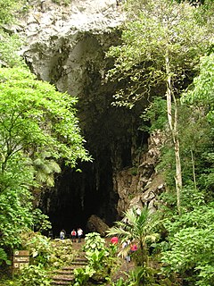
WThe Cueva Alfredo Jahn Natural Monument Also Alfredo Jahn Cave Natural Monument or Tapa de Cambural Cave It is a protected area with the status of a natural monument that is located 4 km west of the town of Birongo, Miranda State, at the eastern end of the Coastal Range of the Cordillera de la Costa. With a 4.29 km gallery development, it is the largest cave in central Venezuela, the sixth in Venezuela and one of the most visited in the country.
 W
WThe Guácharo Cave National Park is located 12 km from the town of Caripe, Monagas, Venezuela. It has as its centerpiece a large limestone cave.
 W
WThe Formaciones de Tepuyes Natural Monument also known as tepui Also Formaciones de Tepuyes Is a protected natural space since 1991, located in Venezuela more specifically in the states of Amazonas and Bolívar. Should not be confused with the Canaima national park that contains part of the tepuyes.
 W
WThe Laguna de las Marites Natural Monument Also Las Marites Lagoon Natural Monument Is a protected area with natural monument status located on the southeast coast of the coastal plain of Margarita Island in Nueva Esparta state in the northwest of the South American country of Venezuela. It was declared a monument on February 27, 1974. It has an extension of 3674 ha, an altitude of 40 msnm and an average temperature of 26 ° C, with hypersaline waters.
 W
WThe Loma de León Natural Monument Also Loma de León Is a natural protected area located in the municipality of Iribarren, belonging to the state of Lara, Venezuela. It received the status of national monument on February 2, 1987.
 W
WThe Meseta la Galera Natural Monument Also La Galera Plateau Is a protected area with the status of a natural monument consisting of a mountainous formation of the state of Mérida in the Andes of the South American country of Venezuela, in the form of Tepuy level plate of approximately 1 km in length. It has an area of 95 ha and has a height of 1055 msnm at its highest point and 935 m.s.n.m. At its lowest point is located between the parishes of El Llano and Tovar in the city center of the city separating this one from the Mocotíes River and the Hill "Loma de La Virgen".
 W
WThe Morros de Macaira Natural Monument Is a protected area with status of natural monument located to the north of Guárico State, part of the South American country of Venezuela. It was created in 1978. It covers an area of 99 ha. Throughout the region, it is common to find limestone rock masses, caves grooved with small water courses and deep vertical tops.
 W
WThe Pico Codazzi Natural Monument Also Codazzi Peak Natural Monument Is a protected area with the status of a natural monument located in the Aragua State in the center of northern Venezuela. It was created in 1991 to connect the Henri Pittier National Park with the Macarao National Park and constitutes one of the highest peaks of the Cordillera de la Costa. It covers an area of 11,850 ha.
WThe Piedra del Cocuy Natural Monument Is a natural protected area located in the Río Negro municipality, in the state of Amazonas, Venezuela. It received the status of natural monument by decree No. 2,986 dated December 12, 1978, published in Official Gazette 2.417-E dated March 7, 1979.
WPiedra del Cocuy is a natural monument in Venezuela, located near the triple border of the country with Brazil and Colombia in the limits of the Amazon and the Orinoco Basins. Piedra del Cocuy is an inselberg made of granitic rock, its peak stands at c. 450 m a.s.l.
 W
WThe Piedra La Tortuga Natural Monument Also Piedra La Tortuga Is a protected natural space located in the Atures municipality, in the Amazonas state, in the south of Venezuela. Received the status of natural monument by decree No. 2.351 of June 5, 1992. Official Gazette No. 35089 of November 11, 1992.
WThe Teta de Niquitao-Guirigay Natural Natural Monument Is a protected natural space located in the Trujillo state, in the Andes of Venezuela. It has the highest mountain in the state with a height of 4006 meters. It is located in the Niquitao parish of Boconó municipality, this Andean landscape is emblematic for all locals. This natural monument was promulgated according to Decree No. 1,473 on September 4, 1996 and published in Official Gazette No. 36.063 on October 11, 1996. It had its justification in the need to protect and preserve unique landscapes consisting of monoclinic ridges, moors and relics of cloud forest, so that INPARQUES guarantees the conservation and preservation of the natural and cultural resources of the area.
 W
WTetas de Maria Guevara are twin hills located near Laguna de la Restinga in central Isla Margarita, Venezuela.
 W
WThe Yutaje Falls is the third-highest waterfall in Venezuela. It is 2,200 ft in height. It is a system of two identical cascades which are located in northern Amazonas state.