 W
WBaffins is an administrative district of Portsmouth, England, located on the eastern side of Portsea Island. The district is mainly composed of 1930s housing and a Roman burial ground which now lies beneath the houses of Whitecliffe Avenue. Legend has it that the Roman soldiers who fought bravely for Julius Caesar are buried at this site and are regularly heard in the middle of the night with their war cries. The population of the Portsmouth ward at the 2011 Census was 15,121.
 W
WCopnor is an area of Portsmouth, England, located on the eastern side of Portsea Island. The population of Copnor Ward at the 2011 Census was 13,608. As Copenore, it was one of the three villages listed as being on Portsea Island in the Domesday book.
 W
WCosham is a northern suburb of Portsmouth lying within the city boundary but off Portsea Island. It is mentioned in the Domesday Book of 1086 along with Drayton and Wymering (mainland) and Bocheland (Buckland), Frodington (Fratton) and Copenore (Copnor) on the island.
 W
WDrayton is a residential area of the city of Portsmouth in the English county of Hampshire. Together with Farlington, its parent area, it makes up one of the electoral wards of the city.
WEastney is a district in the south-east corner of Portsmouth, England, on Portsea Island. Its electoral ward is called Eastney and Craneswater. At the 2011 Census the population of this ward was 13,591.
 W
WFarlington is a primarily residential district of the city of Portsmouth in the county of Hampshire, England. It is located in the extreme north east of the city on the mainland and is not on Portsea Island unlike most of the other areas of Portsmouth. Farlington was incorporated into the city in 1932 and now forms a continuous development with Cosham and Drayton. To the north of Farlington is the suburb of Widley and to the east is the town of Havant. To the west is the suburb of Drayton, and to the south is Langstone Harbour.
 W
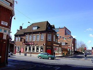
WFratton is a residential and formerly industrial area of Portsmouth in Hampshire, England. Victorian style terraced houses are dominant in the area, typical of most residential areas of Portsmouth. Fratton is home to many discount shops and greasy spoon cafes, as well as the Bridge Centre shopping centre, containing an Asda.
 W
WHilsea is a district of the city of Portsmouth in the English county of Hampshire. Hilsea is home to one of Portsmouth's main sports and leisure facilities – the Mountbatten centre. Trafalgar School is also in Hilsea. It is also the home of Portsmouth rugby football club
 W
WLandport is a district located on Portsea Island and is a central part of the city of Portsmouth, England. The district is centred around Commercial Road and encompasses the Guildhall, Civic Centre, Portsmouth and Southsea Station and Commercial Road central shopping area. The district of Portsea lies to the West; Old Portsmouth, Somers Town and Southsea are to the south; Fratton lies to the East and the Kingston Crescent area to the north.
WMilton is primarily a residential suburb of the English city of Portsmouth, Hampshire, England, on the south eastern side of Portsea Island. Milton is bordered on the eastern coast of Portsea Island by Langstone Harbour, with Eastney to the south-east, Southsea to the south-west, Baffins to the north and Fratton to the north-west.
 W
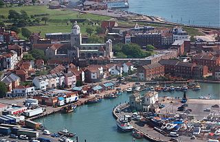
WOld Portsmouth is a district of the city of Portsmouth. It is the area covered by the original medieval town of Portsmouth as planned by Jean de Gisors. It is situated in the south west corner of Portsea Island.
 W
WPaulsgrove is an area of northern Portsmouth, Hampshire, England. Paulsgrove existed as a small hamlet on the old Portsmouth to Southampton road for many years. During the early twentieth century Paulsgrove Racecourse was built north of the village on the slopes of Portsdown Hill and a railway halt built to cater for raceday traffic. The area was incorporated into the city of Portsmouth in 1920. The population of the Portsmouth Ward at the 2011 Census was 14,010.
 W
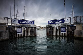
WPort Solent is a housing and leisure development in Portsmouth, Hampshire, comprising a marina and a luxury housing estate. The Port Solent development was built during the 1980s on reclaimed land between the northern side of Horsea Island and the southern shoreline of Paulsgrove in Portsmouth Harbour.
 W
WPortsea Island is a flat, low-lying island measuring 24.542 square kilometres in area, just off the southern coast of England. The island is located within the traditional and ceremonial county of Hampshire and contains the vast majority of the city of Portsmouth.
 W
WRudmore is a district located on the western shore of Portsea Island and is part of the city of Portsmouth, England.
 W
WSomerstown or Somers Town is a residential area of the city of Portsmouth in the English county of Hampshire. The area was one of the most deprived wards in the city, but over the past 20 years it has been the subject of a major regeneration initiative.
 W
WSouthsea is a seaside resort and geographic area, located in Portsmouth at the southern end of Portsea Island, Hampshire, England. Southsea is located to the south of Portsmouth city centre and to the east of Old Portsmouth. It developed as a fashionable Victorian seaside resort in the 19th century, originally named Croxton Town, but later adopting the name of nearby Southsea Castle, a seafront fort constructed in 1544 to help defend the Solent and approaches to Portsmouth Harbour. Southsea subsequently grew into a dense residential suburb and large, distinct commercial and entertainment area, separate from the centre of Portsmouth.
 W
WStamshaw is a residential district of Portsmouth, located on the north western corner of Portsea Island in southern England.
 W
WTipner is a residential district of Portsmouth, located on the north western corner of Portsea Island in southern England. It includes a housing estate, built during the 1930s, that used to function as married quarters for the Royal Navy, a yachting club, allotments, a primary school, The Harbour special school, and indoor and outdoor rifle ranges. There is a nearby sports centre at Alexandra Park. Tipner is bounded to the north and west by the M275 motorway and Tipner Lake. To the south is Stamshaw.
WWidley is an area of the Greater Portsmouth conurbation in the South East of England near Waterlooville and Purbrook. It is on the dip slope of the South Downs just north of the ridge called Portsdown Hill.
 W
WWymering is a residential area of the city of Portsmouth in the English county of Hampshire. Unlike the majority of Portsmouth, it is located on the mainland rather than Portsea Island.