 W
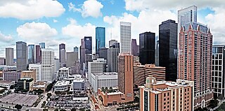
WHouston, the most populous city in the Southern United States, is located along the upper Texas Gulf Coast, approximately 50 miles (80 km) northwest of the Gulf of Mexico at Galveston. The city, which is the ninth-largest in the United States by area, covers 601.7 square miles (1,558 km2), of which 579.4 square miles (1,501 km2), or 96.3%, is land and 22.3 square miles (58 km2), or 3.7%, is water.
 W
WThe Addicks Reservoir and Addicks Dam in conjunction with the Barker Reservoir prevent downstream flooding of Buffalo Bayou in the City of Houston, Texas. Both reservoirs were authorized under the Rivers and Harbors Act of June 20, 1938, which was modified by the Flood Control Acts of August 11, 1938; September 3, 1954; and October 27, 1965. The U.S. Army Corps of Engineers completed construction of Addicks Dam and the outlet facility in 1948.
 W
WBarker Reservoir is a flood control structure in Houston, Texas which prevents downstream flooding of Buffalo Bayou, the city's principal river. The reservoir operates in conjunction with Addicks Reservoir to the northeast, which impounds Mayde and Bear Creeks, two tributaries of the Buffalo. Both reservoirs were authorized under the Rivers and Harbors Act of June 20, 1938, which were modified by the Flood Control Acts of August 11, 1938; September 3, 1954; and October 27, 1965.
WBuckhorn Lake is a private lake in Harris County in the state of Texas, United States. The lake is approximately 60 acres (24 ha) filled with cypress trees and was created by an underwater creek and spring.
 W
WClear Lake is a brackish harbor located near Houston, Texas, U.S., in Harris County. The lake feeds Galveston Bay. It is bordered by Houston, Pasadena, League City, Clear Lake Shores, Taylor Lake Village, Seabrook and El Lago, Texas. NASA's Johnson Space Center lies near its shores.
WDickinson Bay is an inlet of Galveston Bay in Texas, United States within the Greater Houston metropolitan area. It is fed by Dickinson Bayou and the community of San Leon sits on a peninsula to its north.
 W
WThe Edith L. Moore Nature Sanctuary is a 17.5-acre (7.1 ha) nature sanctuary along Rummel Creek, located in Houston, Texas, in the United States. Named after Edith Lotz Moore, who lived on the land with her husband for 43 years, the sanctuary includes a restored log cabin for hosting educational programs and houses administrative offices for the Houston Audubon Society. Since 1975, Houston Audubon has preserved Edith Moore's log cabin in addition to developing trails, creating education programs, constructing an office, and performing outreach from the site. The sanctuary also operates a plant nursery that provides wildflowers and grasses for coastal prairie restoration projects or offered for sale to support the Audubon programs. It specializes in local native prairie grasses and wildflowers with a small selection of understory plants. Moore donated land to the Houston Audubon Society in 1975, to be used as a nature preserve for birds. According to the Houston Audubon Society, the sanctuary's mission is to "provide an urban wildlife sanctuary for native plants and animals and to provide education about the natural environment to Houstonians of all ages." Birding programs and day camps held at the sanctuary serve more than ten thousand children and adults every year. This trail is accessible from 7am-7pm.
 W
WThe Galveston Bay Area, also known as Bay Area Houston or simply the Bay Area, is a region that surrounds the Galveston Bay estuary of Southeast Texas in the United States, within Houston–The Woodlands–Sugar Land metropolitan area. Normally the term refers to the mainland communities around the bay and excludes Galveston as well as most of Houston.
 W
WThe geographic areas of Houston are generally classified as either being inside or outside Interstate 610, known as the "Loop." Inside the loop generally encompasses the Central business district and the "island cities" of West University Place, Southside Place and a portion of Bellaire.
 W
WGreater Houston, designated by the United States Office of Management and Budget as Houston–The Woodlands–Sugar Land, is the fifth-most populous metropolitan statistical area in the United States, encompassing nine counties along the Gulf Coast in Southeast Texas. With a population of 6,997,384 people as of 2018 census estimates and over 7 million in 2019, Greater Houston is the second-most populous in Texas after the Dallas–Fort Worth metroplex. The approximately 10,000-square-mile (26,000 km2) region centers on Harris County, the third-most populous county in the U.S., which contains the city of Houston—the largest economic and cultural center of the South—with a population of more than 2.3 million. Greater Houston is part of the Texas Triangle megaregion along with the Dallas–Fort Worth Metroplex, Greater Austin, and Greater San Antonio. Greater Houston also serves as a major anchor and economic hub for the Gulf Coast. Its Port of Houston is the second largest port in the United States, sixteenth largest in the world, and leads the nation in international trade.
 W
WThe Energy Corridor is a business district in Greater Houston, Texas, located on the west side of the metropolitan area between Beltway 8 and the Grand Parkway. The district straddles a 7-mile (11 km) stretch of Interstate 10 from Kirkwood Road westward to Barker Cypress Road and extends south along Eldridge Parkway to Briar Forest Drive. Parts of the district overlap with the Memorial area of Houston. The district is located north of Westchase, another major business district of Houston, and east of Greater Katy.
 W
WThe Houston Ship Channel, in Houston, Texas, is part of the Port of Houston, one of the busiest seaports in the world. The channel is the conduit for ocean-going vessels between Houston-area terminals and the Gulf of Mexico, and it serves an increasing volume of inland barge traffic.
 W
WThe Houston Skyline District is a geographic area encompassing several blocks of downtown Houston, Texas, United States.
 W
WThe Houston Theater District, a 17-block area in the heart of Downtown Houston, Texas, United States, is home to Houston's nine professional performing arts organizations, the 130,000-square-foot (12,000 m2) Bayou Place entertainment complex, restaurants, movies, plazas, and parks. More than two million people visit the Houston Theater District annually.
WLake Anahuac is an artificial lake fed by the Trinity River, 45 miles (72 km) east of downtown Houston, Texas, United States in western Chambers County. The city of Anahuac lies on its eastern shores. It was constructed by the Burkhalter family in 1953.
WLake Houston is a reservoir on the San Jacinto River, 15 miles (24 km) northeast of downtown Houston, Texas, United States. The reservoir is the primary municipal water supply for the city of Houston.
 W
WMain Street Market Square Historic District is a historic district in Houston that includes the Market Square Park. It includes buildings nearby, as well as the square itself. It was listed on the National Register of Historic Places in 1983.
WMoses Lake is a lake located near Texas City, Texas, US, in the Houston-Sugar Land-Baytown metropolitan area. It is fed by Moses Bayou and drains into Galveston Bay.
 W
WSheldon Lake is a reservoir on Carpenters Bayou in the San Jacinto River basin, 16 miles (26 km) northeast of downtown Houston, Texas. The reservoir was created in 1943 when the federal government built a dam to provide fresh water for shipbuilding and shipping industries on the Houston Ship Channel during World War II. After the war, the management of the reservoir was assumed by the City of Houston. In 1952, after the construction of the dam that creates Lake Houston, the city sold the reservoir to the Texas Parks and Wildlife Department for use as a waterfowl sanctuary and public fishing site. In 1984, the land around the reservoir was designated the Sheldon State Wildlife Management Area.
WTaylor Lake is a lake adjacent to Clear Lake, southeast of Houston, Texas, United States near Galveston Bay. The city of Taylor Lake Village lies on its shores within the Clear Lake Area of the Houston-Sugar Land-Baytown metropolitan area.
 W
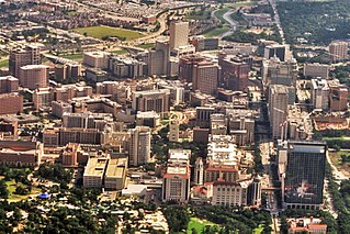
WThe Texas Medical Center (TMC) is a 2.1-square-mile (5.4 km2) medical district and neighborhood in south-central Houston, Texas, immediately south of the Museum District and west of Texas State Highway 288. Over sixty medical institutions, largely concentrated in a triangular area between Brays Bayou, Rice University, and Hermann Park, are members of the Texas Medical Center Corporation—a non-profit umbrella organization—which constitutes the largest medical complex in the world. The TMC has an extremely high density of clinical facilities for patient care, basic science, and translational research.