 W
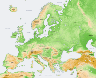
WThe geography of the Czech Republic is quite varied. Bohemia, at the west part of Czech Republic, consists of a river basin, drained by the Elbe and Vltava rivers. It is surrounded by mostly low mountains such as the Sudetes with its part Krkonoše, containing the highest point in the country, the Sněžka at 1,603 metres (5,259 ft). Moravia, the eastern part, is also quite hilly and is drained predominantly by the Morava river, but also contains the source of the Oder river. Water from the landlocked Czech Republic flows to three different seas: the North Sea, Baltic Sea and Black Sea. The Czech Republic also possesses Moldauhafen, a 30,000-square-metre (7.4-acre) enclave in the middle of Hamburg docks, which was awarded to Czechoslovakia by Article 363 of the Treaty of Versailles to allow the landlocked country a place where goods transported downriver could be transferred to seagoing ships; this territory reverts to Germany in 2028.
 W
WBohemia is the westernmost and largest historical region of the Czech lands in the present-day Czech Republic. Bohemia can also refer to a wider area consisting of the historical Lands of the Bohemian Crown ruled by Bohemian kings, including Moravia and Czech Silesia, in which case the region is referred to as Bohemia proper as a means of distinction.
 W
WThe Central European Highlands, in a broad sense, comprise the high mountains of the Alpine Mountains and the Carpathian Mountains systems along with mountainous ranges of medium elevation, e.g. those belonging to the Bohemian Massif, still prevailingly of mountainous character.
 W
WThe Cham-Furth Depression is a lowland in the Upper Palatine-Bavarian Forest that separates the Upper Palatinate Forest from the Bavarian Forest. At the same time it connects the Upper Palatinate with Bohemia.
 W
WEuroregion Cieszyn Silesia is one of the euroregions between Poland and Czech Republic. It has area of 1741,34 km² and 658,224 inhabitants as of 2009. The largest cities are Jastrzębie Zdrój from Polish side and Havířov from Czech side. It was established on 22 April 1998.
 W
WThe Czech lands or the Bohemian lands are the three historical regions of Bohemia, Moravia, and Czech Silesia. Together the three have formed the Czech part of Czechoslovakia since 1918, the Czech Socialist Republic since 1 January 1969 and the Czech Republic since 1 January 1993.
 W
WDobrovíz is located on the west side of Prague, close to Prague International Airport. 477 citizens.
 W
WThe Eger Graben, much less commonly called the Ohre or Ohře Graben, is a geographical unit in the Czech Republic. It runs southwards, parallel to the Ore Mountains and its formation is linked with that of the mountain range.
The Euroregion Pradziad (Polish) or Euroregion Praděd (Czech) is a Euroregion joining parts of the Poland and Czech Republic. It was created on 2 July 1997 in Jeseník.
 W
WThis is a list of the extreme points of the Czech Republic: the points that are farther north, south, east or west than any other location.
 W
WHorňácko is an ethnographic microregion situated in the Hodonín District, South Eastern Moravia, Czech Republic. The region is home to approximately 10,000 people. It is significant for its traditional folk culture, especially the folk music. The region hosts annually the Horňácko Folk Festival.
 W
WThe Hostivické Ponds are a natural monument located at the western edge of Prague, about 4 km from Zličín in the municipalities of Hostivice, Břve and Litovice. This small-scale protected area was established on 14 October 1996 by the District Office of Western Prague with the aim of the conservation of natural communities of the Hostivické pond system.
 W
WKlonk is a Czech national nature monument within the landscape park Český kras which lies in the northern part of the village of Suchomasty, approximately 12 kilometres from Beroun. It is globally recognized as a geologically important location due to the presence of the Global Boundary Stratotype Section and Point (GSSP) marking the boundary between Silurian and Devonian periods. The boundary was set based on the first appearance of the graptolite Monograptus uniformis in the bed number 20. The stratotype was ratified on the 8th of February 1972 by the International Union of Geological Sciences in Montreal as the first formally accepted GSSP.
 W
WMoravia is a historical region in the east of the Czech Republic and one of three historical Czech lands, with Bohemia and Czech Silesia.
 W
WNová Louka is a mountain meadow in Jizera Mountains near the city of Bedřichov, district of Jablonec nad Nisou. It is situated in the north of the Czech Republic, approximately 130 km from Prague. There is Blatny brook flowing through the meadow. Nová Louka is an important cross-road of tourist paths in Jizera Mountains. There is sometimes used an alternative, less common name for the meadow which is Šámalova louka after the Czech politician Přemysl Šámal who resided in the house on the meadow. Šámal was the head of the Office of the President of Czechoslovakia during the First Czechoslovak Republic; he took part in resistance movements during World War I and II, and ultimately died in the Nazi prison in Moabit, Berlin.
 W
WObec is the Czech and Slovak word for a municipality. The literal meaning of the word is "commune" or "community". It is the smallest administrative unit that is governed by elected representatives. Cities and towns are also municipalities.
 W
WThere are at least six types of protected areas of the Czech Republic.
 W
WCzech Silesia is the name given to the part of the historical region of Silesia located in the present-day Czech Republic. While not today an administrative entity in itself, Czech Silesia is, together with Bohemia and Moravia, one of the three historical Czech lands. In this context, it is often mentioned simply as "Silesia", even though it is only around one tenth of the area of the historic land of Silesia.
 W
WEuroregion Silesia is one of Euroregions in Poland and Czechia.
 W
WThe Šluknov Hook or Šluknov Spur or Šluknov Projection is a "panhandle" region found in the northern Czech Republic along the border with Germany. The area is part of the southern Lusatian Highlands, between the Elbe Sandstone Mountains in the west and the Lusatian Mountains in the east. It is administratively included in the northeastern Děčín District. The largest towns in the region are Varnsdorf, Rumburk, and Šluknov, after which it is named. The Šluknov Hook was traditionally closely connected with neighboring Saxony because it also had a German-speaking population. The expulsion of the German-speaking citizens of Czechoslovakia severed the connection, when new Czech-speaking settlers arrived, creating a new linguistic border. The region did not reach pre-war population because it could not attract enough new settlers to replace the expelled German population.
 W
WThe Tisa Rocks or Tisa Walls are a well-known group of rocks in the western Bohemian Switzerland not far from its topographical boundary with the Ore Mountains. The region, with its rock pillars up to 30 m high, is one of the major tourist attractions of Bohemian Switzerland. The Tisa Rocks and their neighbouring Burschlicke Rocks are protected as a national nature reserve.