 W
WThis is a brief summary of the geology of Indonesia.
 W
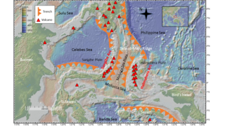
WThe Banda Sea Plate is a minor tectonic plate underlying the Banda Sea in southeast Asia. This plate also carries a portion of Sulawesi Island, the entire Seram Island, and the Banda Islands. Clockwise from the east it is bounded by the Bird's Head Plate of western New Guinea, Australian Plate, Timor Plate, Sunda Plate, and the Molucca Sea Collision Zone.
 W
WReinout Willem van Bemmelen, also known as Rein van Bemmelen, was a Dutch geologist whose interests were structural geology, economic geology and volcanology. He is known for his work on these subjects and the geology of Indonesia.
 W
WThe Bird's Head Plate is a minor tectonic plate incorporating the Bird's Head Peninsula, at the western end of the island of New Guinea. Hillis and Müller consider it to be moving in unison with the Pacific Plate. Bird considers it to be unconnected to the Pacific Plate.
FOSI, Forum Sedimentologiwan Indonesia / Indonesian Sedimentologists Forum sedimentological is a sedimentological section of the Indonesian Geologists Association, which was formed in 1995. The first bulletin was issued in 1996, called Berita Sedimentologi. The bulletin was started as hard copies and in 2010 it has been changed to soft copies and downloadable from FOSI website. FOSI issued the bulletin three times a year.
 W
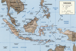
WThe base of rocks that underlie Borneo, an island in Southeast Asia, was formed by the arc-continent collisions, continent–continent collisions and subduction–accretion due to convergence between the Asian, India–Australia, and Philippine Sea-Pacific plates over the last 400 million years. The active geological processes of Borneo are mild as all of the volcanoes are extinct. The geological forces shaping SE Asia today are from three plate boundaries: the collisional zone in Sulawesi southeast of Borneo, the Java-Sumatra subduction boundary and the India-Eurasia continental collision.
 W
WThe Gondwanide orogeny was an orogeny active in the Permian that affected parts of Gondwana that are by current geography now located in southern South America, South Africa, Antarctica, Australia and New Guinea. The zone of deformation in Argentina extends as a belt south and west of the cratonic nucleus of Río de la Plata–Pampia. The deformation of the orogeny is visible in the Sierra de la Ventana mountains in Argentina and the Cape Fold Belt in South Africa. The Gondwanide orogeny might have been linked with the roughly contemporary San Rafael orogeny of western Argentina.
 W
WHalmahera Arc is the volcanic arc of the Halmahera region of eastern Indonesia. It is considered to belong to the Halmahera Plate tectonics, within the Molucca Sea Collision Zone.
 W
WFriedrich Franz Wilhelm Junghuhn, was a German-Dutch botanist and geologist. His father, Friedrich Junghuhn was a barber and a surgeon. His mother was Christine Marie Schiele. Junghuhn studied medicine in Halle and in Berlin from 1827 to 1831, meanwhile (1830) publishing a seminal paper on mushrooms in Limnaea. Ein Journal für Botanik.
 W
WThe Kutai sedimentary basin extends from the central highlands of Borneo, across the eastern coast of the island and into the Makassar Strait. With an area of 60,000 km2, and depths up to 15 km, the Kutai is the largest and deepest Tertiary age basin in Indonesia. Plate tectonic evolution in the Indonesian region of SE Asia has produced a diverse array of basins in the Cenozoic. The Kutai is an extensional basin in a general foreland setting. Its geologic evolution begins in the mid Eocene and involves phases of extension and rifting, thermal sag, and isostatic subsidence. Rapid, high volume, sedimentation related to uplift and inversion began in the Early Miocene. The different stages of Kutai basin evolution can be roughly correlated to regional and local tectonic events. It is also likely that regional climate, namely the onset of the equatorial ever wet monsoon in early Miocene, has affected the geologic evolution of Borneo and the Kutai basin through the present day. Basin fill is ongoing in the lower Kutai basin, as the modern Mahakam River delta progrades east across the continental shelf of Borneo.
 W
WThe Maoke Plate is a small tectonic plate located in western New Guinea underlying the Sudirman Range from which the highest mountain on the island- Puncak Jaya rises. To its east is a convergent boundary with the Woodlark Plate. To the south lies a transform boundary with the Australian Plate and the Bird's Head Plate lies to the west.
 W
WLocated in the western Pacific Ocean near Indonesia, the Molucca Sea Plate has been classified by scientists as a fully subducted microplate that is part of the Molucca Sea Collision Complex. The Molucca Sea Plate represents the only known example of divergent double subduction (DDS), which describes the subduction on both sides of a single oceanic plate.
 W
WThe Nias Basin is a forearc basin located off the western coast of Sumatra, Indonesia, in the Indian Ocean. The name is derived from the island that bounds its western edge, the island of Nias. The Nias Basin, the island of Nias, and the offshore, submarine accretionary complex, together form a Forearc region on the Sunda Plate/Indo-Australian Plate collisional/subduction boundary. The Forearc region is the area between an oceanic trench and its associated volcanic arc. The oceanic trench associated with the Nias Basin is the Sunda Trench, and the associated volcanic arc is the Sunda Arc.
 W
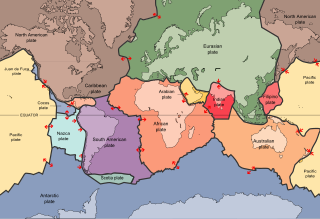
WThe Indo-Australian Plate is a major tectonic plate that includes the continent of Australia and surrounding ocean, and extends northwest to include the Indian subcontinent and adjacent waters. It was formed by the fusion of Indian and Australian plates approximately 43 million years ago. The fusion happened when the mid-ocean ridge in the Indian Ocean, which separated the two plates, ceased spreading.
 W
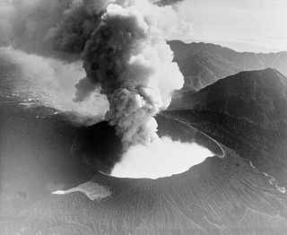
WThe Sidoarjo mud flow is the result of an erupting mud volcano in the subdistrict of Porong, Sidoarjo in East Java, Indonesia that has been in eruption since May 2006. It is the biggest mud volcano in the world; responsibility for it was credited to the blowout of a natural gas well drilled by PT Lapindo Brantas, although some scientists and company officials contend it was caused by a distant earthquake.
 W
WThe Sunda Arc is a volcanic arc that produced the volcanoes that form the topographic spine of the islands of Sumatra, Nusa Tenggara, and Java, the Sunda Strait and the Lesser Sunda Islands. The Sunda Arc begins at Sumatra and ends at Flores, and is adjacent to the Banda Arc. The Sunda Arc is formed via the subduction of the Indo-Australian Plate beneath the Sunda and Burma plates at a velocity of 63-70 mm/year.
 W
WThe Sunda Islands are a group of islands in the Malay Archipelago.
 W
WThe Sunda Plate is a minor tectonic plate straddling the Equator in the Eastern Hemisphere on which the majority of Southeast Asia is located.
 W
WGeologically, the Sunda Shelf is a southeast extension of the continental shelf of Southeast Asia. Major landmasses on the shelf include the Malay Peninsula, Sumatra, Borneo, Java, Madura, Bali and their surrounding smaller islands. It covers an area of approximately 1.85 million km2. Sea depths over the shelf rarely exceed 50 metres and extensive areas are less than 20 metres resulting in strong bottom friction and strong tidal friction. Steep undersea gradients separate the Sunda Shelf from the Philippines, Sulawesi, and the Lesser Sunda Islands.
 W
WThe Sunda Trench, earlier known as and sometimes still indicated as the Java Trench, is an oceanic trench located in the Indian Ocean near Sumatra, formed where the Australian-Capricorn plates subduct under a part of the Eurasian Plate. It is 3,200 kilometres (2,000 mi) long with a maximum depth of 23,920 feet. Its maximum depth is the deepest point in the Indian Ocean. The trench stretches from the Lesser Sunda Islands past Java, around the southern coast of Sumatra on to the Andaman Islands, and forms the boundary between Indo-Australian Plate and Eurasian plate. The trench is considered to be part of the Pacific Ring of Fire as well as one of a ring of oceanic trenches around the northern edges of the Australian Plate.
 W
WThe Timor Plate is a microplate in southeast Asia carrying the island of Timor and surrounding islands. The Australian Plate is subducting under the southern edge of the plate, while a small divergent boundary is located on the eastern edge. Another convergent boundary exists with the Banda Sea Plate to the north, and to the west is a transform boundary.