 W
WThe geology of North America is a subject of regional geology and covers the North American continent, third-largest in the world. Geologic units and processes are investigated on a large scale to reach a synthesized picture of the geological development of the continent.
 W
WThe Alleghanian orogeny or Appalachian orogeny is one of the geological mountain-forming events that formed the Appalachian Mountains and Allegheny Mountains. The term and spelling Alleghany orogeny was originally proposed by H.P. Woodward in 1957.
 W
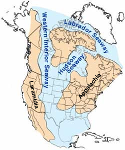
WDuring most of the Late Cretaceous the eastern half of North America formed Appalachia, an island land mass separated from Laramidia to the west by the Western Interior Seaway. This seaway had split North America into two massive landmasses due to a multitude of factors such as tectonism and sea-level fluctuations for nearly 40 million years. The seaway eventually expanded, divided across the Dakotas, and by the end of the Cretaceous, it retreated towards the Gulf of Mexico and the Hudson Bay. This left the island masses joined in the continent of North America as the Rocky Mountains rose. From the Cenomanian to the end of the Campanian ages of the Late Cretaceous, Appalachia was separated from the rest of North America. As the Western Interior Seaway retreated in the Maastrichtian, Laramidia and Appalachia eventually connected. Because of this, its fauna was isolated, and developed very differently from the tyrannosaur, ceratopsian, hadrosaurid, pachycephalosaur and ankylosaurid dominated fauna of the western part of North America, known as "Laramidia".
 W
WThe Canadian Shield, also called the Laurentian Plateau, is a large area of exposed Precambrian igneous and high-grade metamorphic rocks that forms the ancient geologic core of the North American continent. Glaciation has left the area only a thin layer of soil, through which the composition of igneous rock resulting from long volcanic history is frequently visible. With a deep, common, joined bedrock region in eastern and central Canada, the Shield stretches north from the Great Lakes to the Arctic Ocean, covering over half of Canada and most of Greenland; it also extends south into the northern reaches of the United States. Human population is sparse and industrial development is minimal, but mining is prevalent.
 W
WThe Churchill Craton is the northwest section of the Canadian Shield and stretches from southern Saskatchewan and Alberta to northern Nunavut. It has a very complex geological history punctuated by at least seven distinct regional tectonometamorphic intervals, including many discrete accretionary magmatic events. The Western Churchill province is the part of the Churchill Craton that is exposed north and west of the Hudson Bay. The Archean Western Churchill province contributes to the complicated and protracted tectonic history of the craton and marks a major change in the behaviour of the Churchill Craton with many remnants of Archean supracrustal and granitoid rocks.
 W
WThe Eastern North America Rift Basins are a series of sediment-filled aborted rifts created by large-scale continental extension. Their positions closely mirror the eastern coast of North America.
 W
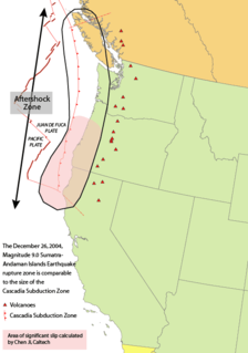
WThe Farallon Plate was an ancient oceanic plate that began subducting under the west coast of the North American Plate—then located in modern Utah—as Pangaea broke apart during the Jurassic period. It is named for the Farallon Islands, which are located just west of San Francisco, California.
WThe geology of Ontario consists of the study of the rock formations in the most populated province of Canada. Ontario has some of the oldest rocks on Earth. It is made up of ancient Precambrian igneous and metamorphic rock and overlain by younger sedimentary rocks and soils.
 W
WThe Hearne Craton is a craton in northern Canada which, together with the Rae Craton, forms the Western Churchill Province. Hearne is one of the six Archaean cratons of the Canadian Shield that are bound together by Palaeoproterozoic orogenic belts. Before being merged these six cratons formed independent microcontinents.
WLaramidia was an island continent that existed during the Late Cretaceous period, when the Western Interior Seaway split the continent of North America in two. In the Mesozoic era, Laramidia was an island land mass separated from Appalachia to the east by the Western Interior Seaway. The seaway eventually shrank, split across the Dakotas, and retreated towards the Gulf of Mexico and the Hudson Bay. The masses joined to unite the North American continent.
 W
WLaurasia, a portmanteau for Laurentia and Asia, was the more northern of two minor supercontinents that formed part of the Pangaea supercontinent from c. 425 million years ago (Mya) to 200 Mya. It separated from Gondwana 215 to 175 Mya during the breakup of Pangaea, drifting farther north after the split and finally broke apart with the opening of the North Atlantic Ocean c. 56 Mya.
 W
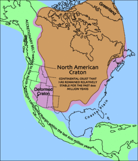
WLaurentia or the North American Craton is a large continental craton that forms the ancient geological core of North America. Many times in its past, Laurentia has been a separate continent, as it is now in the form of North America, although originally it also included the cratonic areas of Greenland and also the northwestern part of Scotland, known as the Hebridean Terrane. During other times in its past, Laurentia has been part of larger continents and supercontinents and itself consists of many smaller terranes assembled on a network of Early Proterozoic orogenic belts. Small microcontinents and oceanic islands collided with and sutured onto the ever-growing Laurentia, and together formed the stable Precambrian craton seen today.
WLaurentia or the North American Craton is a large continental craton that forms the ancient geological core of North America. Many times in its past, Laurentia has been a separate continent, as it is now in the form of North America, although originally it also included the cratonic areas of Greenland and also the northwestern part of Scotland, known as the Hebridean Terrane. During other times in its past, Laurentia has been part of larger continents and supercontinents and itself consists of many smaller terranes assembled on a network of Early Proterozoic orogenic belts. Small microcontinents and oceanic islands collided with and sutured onto the ever-growing Laurentia, and together formed the stable Precambrian craton seen today.
 W
WThe North American Plate is a tectonic plate covering most of North America, Greenland, Cuba, the Bahamas, extreme northeastern Asia, and parts of Iceland and the Azores. With an area of 76 million km2 (29 million sq mi), it is the Earth's second largest tectonic plate, behind the Pacific Plate.
 W
WThe Pacific Coast Ranges, are the series of mountain ranges that stretch along the West Coast of North America from Alaska south to Northern and Central Mexico.
WThe Rae Craton is an Archean craton located in northern Canada north of the Superior Craton.
 W
WSWEAT stands for southwestern United States and East Antarctica, which theorizes that the Southwestern United States was at one time connected to East Antarctica. A hypothesis for a late Precambrian fit of western North America with the Australia-Antarctic shield region permits the extension of many features through Antarctica and into other parts of Gondwana, specifically, the Grenville orogen may extend around the coast of East Antarctica into India and Australia. The ophiolitic belt of the latter may extend into East Antarctica. The Wopmay orogen of northwest Canada may extend through eastern Australia into Antarctica and thence beneath the ice to connect with the Yavapai-Mazatzal orogens of the southwestern United States. Counterparts of the Precambrian-Paleozoic sedimentary rocks along the U.S. Cordilleran miogeocline may be present in the Transantarctic Mountains. Orogenic belt boundaries provide useful piercing points for Precambrian continental reconstructions. The model implies that Gondwana and Laurentia drifted away from each other on one margin and collided some 300 million years later on their opposite margins to form the Appalachians.
WThe Trans-Hudson orogeny or Trans-Hudsonian orogeny was the major mountain building event (orogeny) that formed the Precambrian Canadian Shield, the North American Craton, and the forging of the initial North American continent. It gave rise to the Trans-Hudson orogen (THO), or Trans-Hudson Orogen Transect (THOT), which is the largest Paleoproterozoic orogenic belt in the world. It consists of a network of belts that were formed by Proterozoic crustal accretion and the collision of pre-existing Archean continents. The event occurred 2.0-1.8 billion years ago.
 W
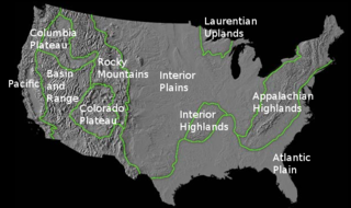
WThe richly textured landscape of the United States is a product of the dueling forces of plate tectonics, weathering and erosion. Over the 4.5 billion-year history of our Earth, tectonic upheavals and colliding plates have raised great mountain ranges while the forces of erosion and weathering worked to tear them down. Even after many millions of years, records of Earth's great upheavals remain imprinted as textural variations and surface patterns that define distinctive landscapes or provinces.
WThe Western Interior Seaway was a large inland sea that existed during the mid- to late Cretaceous period as well as the very early Paleogene, splitting the continent of North America into two landmasses, Laramidia to the west and Appalachia to the east. The ancient sea stretched from the Gulf of Mexico and through the middle of the modern-day countries of the United States and Canada, meeting with the Arctic Ocean to the north. At its largest, it was 2,500 feet (760 m) deep, 600 miles (970 km) wide and over 2,000 miles (3,200 km) long.
WThe Wyoming Craton is a craton in the west-central United States and western Canada – more specifically, in Montana, Wyoming, southern Alberta, southern Saskatchewan, and parts of northern Utah. Also called the Wyoming Province, it is the initial core of the continental crust of North America.