 W
WThe basic principles of air navigation are identical to general navigation, which includes the process of planning, recording, and controlling the movement of a craft from one place to another.
 W
WIn air navigation, the 1 in 60 rule is a rule of thumb which states that if a pilot has travelled sixty miles then an error in track of one mile is approximately a 1° error in heading, and proportionately more for larger errors. The rule is used by single pilots with many other tasks to perform, often in a basic aircraft without the aid of an autopilot, who need a simple process that can be performed in their heads. This rule is also used by air traffic controllers to quickly determine how much to turn an aircraft for separation purposes.
 W
WAn air data module is a component of the navigation system. Each unit converts pneumatic information from a pitot tube or a static port into numerical information which is sent on a data bus. This pressure information is received and processed by the Air Data Reference (ADR) component of the Air Data Inertial Reference Unit (ADIRU). This processed information is then sent to one or more display management computers that present information on the cockpit's primary flight display. Airspeed information is also sent to the flight computers and other electronics, including the autoflight subsystem.
 W
WAn aerodrome reference point (ARP), in some countries airport reference point, is the designated geographical location of an aerodrome. The geographic coordinates of an ARP are part of an aerodrome's entry in the AIP.
 W
WAn astrodome is a hemispherical transparent dome that was installed in the cabin roof of an aircraft. Such a dome would allow a trained navigator to perform astronavigation and thereby guide the aircraft at night without the aid of land-based visual references.
 W
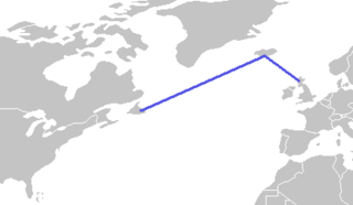
WThe Atlantic Bridge is a flight route from Gander, Newfoundland, Canada to Scotland, with a refueling stop in Iceland.
 W
WAn automatic direction finder (ADF) is a marine or aircraft radio-navigation instrument that automatically and continuously displays the relative bearing from the ship or aircraft to a suitable radio station. ADF receivers are normally tuned to aviation or marine NDBs operating in the LW band between 190 – 535 kHz. Like RDF units, most ADF receivers can also receive medium wave (AM) broadcast stations, though as mentioned, these are less reliable for navigational purposes.
 W
WBig Fence was a secret navigational aid for US Army Air Force sorties from North Africa and Italy during World War II, ultimately located at the Castel del Monte in Apulia. It was operated by the 6649th Navigational Aids Squadron of the 341st Signal Company, XV Fighter Command, 15th Army Air Force.
 W
WIn navigation, the course of a watercraft or aircraft is the cardinal direction in which the craft is to be steered. The course is to be distinguished from the heading, which is the compass direction in which the craft's bow or nose is pointed.
 W
WIn aviation, a critical area refers to a designated area of an airport that all aircraft, vehicles, persons or physical obstructions must remain clear of when one or more Instrument Landing Systems (ILS) are in use, to protect against signal interference or attenuation that may lead to navigation errors, or accident. Critical areas also protect the ILS system's internal monitoring.
 W
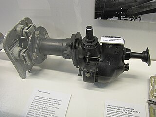
WA drift meter, also drift indicator and drift sight, is an optical device used to improve dead reckoning for aircraft navigation by measuring wind effect on flight.
 W
WIn aviation, an intersection is a virtual navigational fix that helps aircraft maintain their flight plan. It is usually defined as the intersection of two VOR radials. They are usually identified as major airway intersections where aircraft, operating under instrument flight rules, often change direction of flight while en route. According to the Federal Aviation Regulations, some intersections are designated as mandatory reporting points for pilots who are not in radar contact with air traffic control.
 W
WKorean Air Cargo Flight 8509 was a Boeing 747-2B5F, registered HL7451 and bound for Milano-Malpensa Airport, that crashed due to instrument malfunction and pilot error on 22 December 1999 shortly after take-off from London Stansted Airport where the final leg of its route from South Korea to Italy had begun. The aircraft crashed into Hatfield Forest near the village of Great Hallingbury, close to but clear of some houses. All four crew on board were killed.
 W
WMissed approach point is the point prescribed in each instrument approach at which a missed approach procedure shall be executed if the required visual reference does not exist. It defines the point for both precision and non-precision approaches wherein the missed approach segment of an approach procedure begins. A pilot must execute a missed approach if a required visual reference is not in sight upon reaching the MAP or the pilot decides it is unsafe to continue with the approach and landing to the runway. The missed approach point is published in the approach plates and contains instructions for missed approach procedures to be executed at this point.
 W
WMustique Airport is a private airfield owned by the Mustique Company for public use and is located on Mustique island, part of Saint Vincent and the Grenadines in the Caribbean Sea. It is used by civil aviation and national airlines using turboprop planes.
 W
WA Pundit Beacon or Landmark Beacon was an airfield navigational and identification beacon, used by the British Royal Air Force (RAF) in the period around World War II.
 W
WA tactical air navigation system, commonly referred to by the acronym TACAN, is a navigation system used by military aircraft. It provides the user with bearing and distance to a ground or ship-borne station. It is a more accurate version of the VOR/DME system that provides bearing and range information for civil aviation. The DME portion of the TACAN system is available for civil use; at VORTAC facilities where a VOR is combined with a TACAN, civil aircraft can receive VOR/DME readings. Aircraft equipped with TACAN avionics can use this system for en route navigation as well as non-precision approaches to landing fields. The space shuttle is one such vehicle that was designed to use TACAN navigation but later upgraded with GPS as a replacement.
 W
WIn the United States and Canada, Victor airways are low-altitude airways. They are defined in straight-line segments, each of which is based on a straight line between either two VHF omnidirectional range (VOR) stations, or a VOR and a VOR intersection, hence the beginning letter V.
 W
WA VORTAC is a radio-based navigational aid for aircraft pilots consisting of a co-located VHF omnidirectional range (VOR) beacon and a tactical air navigation system (TACAN) beacon. Both types of beacons provide pilots azimuth information, but the VOR system is generally used by civil aircraft and the TACAN system by military aircraft. However, the TACAN distance measuring equipment is also used for civil purposes because civil DME equipment is built to match the military DME specifications. Most VOR installations in the United States are VORTACs. The system was designed and developed by the Cardion Corporation.
 W
WAn airway or air route is a defined corridor that connects one specified location to another at a specified altitude, along which an aircraft that meets the requirements of the airway may be flown. Airways are defined with segments within a specific altitude block, corridor width, and between fixed geographic coordinates for satellites navigation system, or between ground-based Radio transmitter navigational aids or the intersection of specific radials of two navaids.
 W
WIn air navigation, the wind triangle is a graphical representation of the relationship between aircraft motion and wind. It is used extensively in dead reckoning navigation.
 W
WA World Aeronautical Chart (WAC) is a type of aeronautical chart used for navigation by pilots of moderate speed aircraft and aircraft at high altitudes. They are at a scale of 1:1,000,000.