 W
WBandon Bay is a bay in the Gulf of Thailand in Surat Thani Province, extending from the Sui cape in Chaiya District in the northwest to Kanchanadit District to the east. The total coastline is about 100 km. The bay is dominated by the estuary of the rivers Tapi and Phum Duang. The islands of Ko Samui, Ko Pha Ngan and Ko Tao enclose the bay on its eastern side.
 W
WCheow Lan Lake or Rajjaprabha Dam Reservoir, is in Khao Sok National Park in Surat Thani Province, Thailand. It is an 185-square-kilometre (71 sq mi) artificial lake, inaugurated in 1987 with the construction of Rajjaprabha Dam by the Electricity Generating Authority of Thailand (EGAT) as a source of electricity.
 W
WHat Khanom–Mu Ko Thale Tai is a national park in the process of being established as of 2015. It is in southern Thailand, covering territory of the districts Khanom and Sichon of Nakhon Si Thammarat Province and Don Sak and Ko Samui of Surat Thani Province.
 W
WHat Rin is a peninsular beach area and town on the southern tip of Ko Pha-ngan, an island in the Gulf of Thailand. Its two main beaches are Sunset Beach to the south and the larger Sunrise Beach to the north. A Full Moon Party takes place on Sunrise Beach each month.
 W
WKaeng Krung National Park is a national park in southern Thailand, protecting 541 km2 of forests in the Phuket mountain range. It was declared a national park on 4 December 1991.
 W
WKhao Sok National Park is in Surat Thani Province, Thailand. Its area is 739 km2 (285 sq mi), and it includes the 165 km2 (64 sq mi) Cheow Lan Lake contained by the Ratchaprapha Dam. The park is the largest area of virgin forest in southern Thailand and is a remnant of rain forest which is older and more diverse than the Amazon rain forest.
 W
WKhao Tha Phet is a hill near the town of Surat Thani, southern Thailand. It is located in Tambon Makham Tia, Amphoe Mueang Surat Thani. The hill has an altitude of about 210m (689ft) above sea level and offers a good view over the town Surat Thani.
 W
WKhlong Phanom is a national park in southern Thailand, protecting 410.4 km² of forests within the Phuket mountain range. It was declared a national park on November 17, 2000.
 W
WKhlong Phraya is a wildlife sanctuary in southern Thailand, at the boundary of Surat Thani and Krabi Provinces.
WKhlong Saeng is a wildlife sanctuary in southern Thailand, in western Surat Thani Province. The wildlife sanctuary is named after the river (khlong) Saeng, a tributary of the Phum Duang River.
WKhlong Yan is a wildlife sanctuary in southern Thailand, located in the west of Surat Thani Province. It is located between the Khao Sok and Kaeng Krung National Park within the hills of the Phuket mountain range.
 W
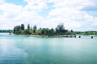
WKo Lamphu (เกาะลำพู) is a small island in the Tapi River, Thailand, about 9 km from the river's mouth, near the town center of Surat Thani. It is connected by bridge to the city at the pillar shrine.
 W
WKo Phaluai or "เกาะพะลวย" in Thai, is the biggest island in the Mu Ko Ang Thong island group. It is inhabited by sea-gypsies who still earn a living from fishing.
 W
WKo Samui is an island off the east coast of Thailand. Geographically in the Chumphon Archipelago, it is part of Surat Thani Province, though as of 2012, Ko Samui was granted municipal status and thus is now locally self-governing. Ko Samui, with an area of 228.7 square kilometres (88.3 sq mi), is Thailand's second largest island after Phuket. In 2018, it was visited by 2.7 million tourists.
 W
WKo Taen is an island, approximately 15 kilometers off the mainland and five kilometers south of Ko Samui in the Gulf of Thailand. It is part of the Samui archipelago, which includes about 60 other islands. Just northwest of Ko Taen is the Mu Ko Ang Thong National Park.
 W
WKo Tao is an island in Thailand and is part of the Chumphon Archipelago on the western shore of the Gulf of Thailand. It covers an area of about 21 km2. Administratively it is a subdistrict (tambon) of Ko Pha-ngan District (amphoe) of Surat Thani Province. As of 2006 its official population was 1,382. The main settlement is Ban Mae Hat.
 W
WThe Monthon Surat was an administrative subdivision of Thailand at the beginning of the 20th century. It covered the northeastern part of southern Thailand.
 W
WMu Ko Ang Thong is a marine national park in the Gulf of Thailand in Surat Thani Province. It covers 42 islands in a total area of 102 km2, of which about 50 km2 are land and the rest is water. The park was established on 12 November 1980. The northern tip of Ko Phaluai is also part of the marine park. There is a ranger station, bungalows, a shop, and a restaurant at Ao Phi Beach on Ko Wua Talap.
 W
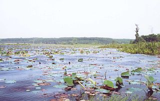
WNong Thung Thong is a swamp on the east bank of the Tapi River in Khian Sa District, Surat Thani Province, southern Thailand.
 W
WTai Romyen National Park is in the east of Surat Thani Province in southern Thailand. The park consists of the northern end of the Nakhon Si Thammarat mountain range and is mostly covered with forests. It was established on 31 December 1991 and covers an area of 425 km2 in the districts Kanchanadit, Ban Na San, and Wiang Sa.
 W
WThe Tapi river is the longest river in southern Thailand. The river originates at Khao Luang mountain in Nakhon Si Thammarat Province, and empties into the Gulf of Thailand at Bandon Bay near the town of Surat Thani. It has a length of 230 kilometres (140 mi).
 W
WThan Sadet–Ko Pha-ngan is a national park in southern Thailand, protecting 65.93 km2 (25.46 sq mi) mostly on the island Pha-ngan. The park was established on December 31, 1983. It covers an area of 39.12 km2 (15.10 sq mi), and was enlarged to its present size on February 10, 1999.