 W
WThe Águeda is a river tributary of the Douro River, that springs from the Serra das Mesas in Spain, in the autonomous community of Castile and León. It flows 130 kilometres (81 mi) until it reaches the Douro River near Barca de Alva, Portugal. The Portugal–Spain border follows the Águeda for much of its course.
 W
WThe Algar do Carvão is an ancient lava tube or volcanic vent located in the central part of the island of Terceira in the Portuguese archipelago of the Azores. It lies within the civil parish of Porto Judeu in the municipality of Angra do Heroísmo.
 W
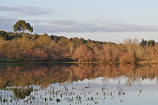
WThe Protected Landscape of Lagoas de Bertiandos e São Pedro de Arcos is a protected landscape situated in the municipality of Ponte de Lima, in the district of Viana do Castelo in Portugal.
 W
WBoquilobo Bog Natural Reserve is a natural reserve in Portugal, located near Golegã. The marshland between Tagus and Almonda River is one of the 30 areas which are officially under protection in the country. UNESCO declared it to be a biosphere reserve.
 W
WCastro Marim and Vila Real de Santo António Marsh Natural Reserve is a natural reserve in Portugal.
 W
WCorvo Island, literally the Island of the Crow, is the smallest and the northernmost island of the Azores archipelago and the northernmost in Macaronesia, has a population of approximately 468 inhabitants constituting the smallest single municipality in the Azores and in Portugal, and lies within the North American Plate.
 W
WThe Fajã dos Cubres is a permanent debris field, known as a fajã, built from the collapsing cliffs on the northern coast of the civil parish of Ribeira Seca, in the municipality of Calheta, island of São Jorge, in the Portuguese archipelago of the Azores.
 W
WThe Formigas Islets, sometimes referred to as the Formigas Bank, are a group of uninhabited rocky outcroppings in the eastern group of the Azores archipelago, an autonomous region of Portugal. The bank is located 43 kilometres (27 mi) northeast of Santa Maria and southeast of São Miguel, covering a surface area of approximately 9,000 square metres (97,000 sq ft). In the same area is the submerged Dollabarat Reef. The only structure on the islets is a lighthouse located on Formigão, the largest islet.
 W
WGraciosa Island is referred to as the White Island, the northernmost of the Central Group of islands in the Azores. The ovular Portuguese island has an area of 60.65 square kilometres, a length of 10 kilometres and a width of 7 kilometres. It is a volcanic island, dominated by a 1.6-kilometre-wide (1.0-mile) central caldera located in the southeast.
 W
WLagoa da Fajã de Santo Cristo is a lagoon located on the north coast of the Portuguese island of São Jorge. The lagoon was listed along with Lagoa da Fajã dos Cubres as a "Wetland of International Importance" under the Ramsar Convention in 2005. The fajãs and coastal area connecting the two lagoons make up the remainder of the wetland.
 W
WLagoa da Fajã dos Cubres is a lagoon located in the parish of Ribeira Seca, on the north coast of the Portuguese island of São Jorge. The lagoon was listed along with Lagoa da Caldeira as a "Wetland of International Importance" under the Ramsar Convention in 2005. The term fajã refers to the plain areas created from landslides of the abrupt coastal cliffs.
 W
WThe Nature Park of Faial, or simply or Nature Park of Faial (PNF) developed from the intention of better managing the protected areas of the island of Faial, and was instituted by the Secretaria Regional do Ambiente e do Mar, of the Autonomous Regional Government of the Azores.
 W
WThe Nature Park of Flores, or simply or Nature Park of Flores (PNF) developed from the intention of better managing the protected areas of the island of Flores, and was instituted by the Secretaria Regional do Ambiente e do Mar, of the Autonomous Regional Government of the Azores. Although there are several ecosystems and environmentally distinct, this nature reserve includes three principal areas, in addition to several protected areas.
 W
WThe Nature Park of Terceira (Portuguese: Parque Natural de Terceira, or simply the Terceira Nature Park developed from the intention of better managing the protected areas of the island of Terceira, and was instituted by the "Secretaria Regional do Ambiente e do Mar", of the Autonomous Regional Government of the Azores. It includes an area of approximately 22% of the island classified under the International Union for Conservation of Nature's Nature Reserve designation.
 W
WPaul de Arzila is a Portuguese natural reserve occupying an area in Coimbra municipality, and neighbouring municipalities of Condeixa-a-Nova and Montemor-o-Velho. It is a biogenetical reserve with an area of 150 ha framed in a protected area of 535 ha, where 119 species of birds, 12 of mammals, 10 of reptiles and 13 of fish were inventoried.
 W
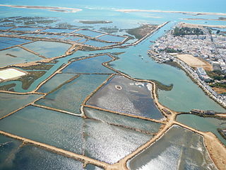
WThe Ria Formosa lagoon, located in the Algarve, in southern Portugal, is a system of barrier islands that communicates with the sea through six inlets. Five of these inlets are natural and have mobility characteristics. The sixth is an artificial inlet that was opened with the purpose of allowing easier access to the port of Faro.
 W
WSado Estuary Natural Reserve is a nature reserve in Portugal. It is one of the 30 areas which are officially under protection in the country. It is located between the municipalities of Alcácer do Sal, Comporta and Setúbal.
 W
WSanta Maria Natural Park is a protected area on Santa Maria Island in the Azores. The park was created by the Secretaria Regional do Ambiente e do Mar, of the Autonomous Regional Government of the Azores to better manage the protected areas of Santa Maria Island. Several natural landscapes were preserved and their use conditioned in order to foster conservation and support endemic flora and fauna species, as well as provide communal forms of recreation and nature interpretation.
 W
WSanto André and Sancha Lagoons Natural Reserve is a natural reserve in Portugal. It is one of the 30 areas which are officially under protection in the country.
 W
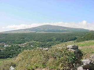
WSerra da Estrela Natural Park is situated in the largest mountain range in Portugal - the Serra da Estrela, and is the source of the rivers Mondego, Zêzere, and Alva. The park is the largest natural conservation area in Portugal and occupies about 1,000 km². More than half of its area is located above an altitude of 700 m. At 1,993 m it contains the highest peak in Continental Portugal and a ski resort.
 W
WTagus Estuary Natural Reserve is a natural reserve in Portugal. It is one of the 30 areas which are officially under protection in the country. The estuary of the Tagus River is the largest wetland in the country and one of the most important in Europe, a sanctuary for fish, molluscs, crustaceans, and especially to birds that stop-over on their migration between northern Europe and Africa. It is the largest estuary in western Europe, with about 34,000 hectares, and regularly hosts 50,000 wintering waterfowl
 W
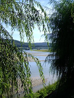
WThe Zêzere is a river in Portugal, tributary to the Tagus. It rises in the Serra da Estrela, near the Torre, the highest point of continental Portugal. The Zêzere runs through the town Manteigas, runs through Belmonte, passes south of the city Covilhã and east of the town of Pedrogão Grande. It flows into the Tagus in Constância. It is the second longest river entirely within Portuguese territory. Its slope allows for the hydroelectric powerplants of Cabril, Bouçã and Castelo de Bode.