 W
WJoan Blaeu was a Dutch cartographer born in Alkmaar, the son of cartographer Willem Blaeu.
 W
WWillem Janszoon Blaeu, also abbreviated to Willem Jansz. Blaeu, was a Dutch cartographer, atlas maker and publisher. Along with his son Johannes Blaeu, Willem is considered one of the notable figures of the Netherlandish/Dutch school of cartography in its golden age.
 W
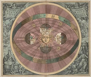
WAndreas Cellarius was a Dutch–German cartographer and cosmographer best known for his 1660 Harmonia Macrocosmica, a major star atlas.
 W
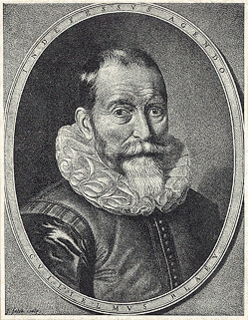
WHessel Gerritsz was a Dutch engraver, cartographer, and publisher. He was one of the notable figures in the Golden Age of Netherlandish cartography. Despite strong competition, he is considered by some "unquestionably the chief Dutch cartographer of the 17th century".
 W
WAbraham Goos was a Dutch cartographer, publisher, and engraver. He made globes, maps of North America, a comprehensive map of European coastlines, and the first printed Hebrew language map of The Holy Land.
 W
WPieter Goos (1616–1675) was a Dutch cartographer, copperplate engraver, publisher and bookseller. He was the son of Abraham Goos (1590–1643), also a cartographer and map seller. From 1666, Pieter Goos published a number of well produced atlases. He was the first to map Christmas Island, which he labelled "Mony" in his map of the East Indies, published in his 1666 Zee-Atlas. His Atlas ofte Water-Weereld has been cited as one of the best maritime atlases of its time. Another of his fine works was the Oost Indien map published in 1680.
 W
WJodocus Hondius was a Flemish engraver and cartographer. He is sometimes called Jodocus Hondius the Elder to distinguish him from his son Jodocus Hondius II. Hondius is best known for his early maps of the New World and Europe, for re-establishing the reputation of the work of Gerard Mercator, and for his portraits of Francis Drake. One of the notable figures in the Golden Age of Dutch/Netherlandish cartography, he helped establish Amsterdam as the center of cartography in Europe in the 17th century.
 W
WWillem Hondius or Willem Hondt was a Dutch engraver, cartographer and painter who spent most of his life in Poland.
 W
WFrederick de Houtman was a Dutch explorer, navigator, and colonial governor who sailed on the first Dutch expedition to the East Indies from 1595 until 1597, during which time he made observations of the southern celestial hemisphere and contributed to the creation of 12 new southern constellations.
 W
WJohannes Janssonius was a Dutch cartographer and publisher who lived and worked in Amsterdam in the 17th century.
 W
WPieter van den Keere was a Flemish engraver, publisher and globe maker who worked for the most part of his career in England and the Dutch Republic.
 W
WJohannes van Keulen was a 17th-century Dutch cartographer. He published the influential nautical atlas the Zee-Atlas and the pilot guide Zee-Fakkel.
 W
WGeorg Marcgrave was a German naturalist and astronomer, whose posthumously published Historia Naturalis Brasiliae was a major contribution to early modern science.
 W
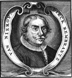
WDirck Rembrandtsz van Nierop was a seventeenth-century Dutch cartographer, mathematician, surveyor, astronomer, teacher and vermaner.
 W
WPetrus Plancius was a Dutch-Flemish astronomer, cartographer and clergyman. He was born as Pieter Platevoet in Dranouter, now in Heuvelland, West Flanders. He studied theology in Germany and England. At the age of 24 he became a minister in the Dutch Reformed Church.
 W
WGerrit Lucasz van Schagen or Schaagen (ca. 1642 – c. March 1724 was an engraver and cartographer from Amsterdam, known for his exquisite reproductions of maps, particularly of those by Nicolaes Visscher I and Frederick de Wit. He lived and worked in Amsterdam, on the Haarlemmerdijk near the New Haarlem sluice at the house with the sign "In de Stuurman".
 W
WJohan Sems, sometimes known as Johan Semp, was a Dutch cartographer, engineer and land surveyor. He specialized in land reclamation and the building of dikes and fortifications.
 W
WJohannes Vingboons was a Dutch cartographer and watercolourist.
 W
WClaes Janszoon Visscher was a Dutch Golden Age draughtsman, engraver, mapmaker, and publisher.
 W
WMaarten Gerritszoon Vries, or Fries, also referred to as de Vries, was a 17th-century Dutch cartographer and explorer, the first Western European to leave an account of his visit to Ezo, Sakhalin, Kuril Islands and the Sea of Okhotsk.
 W
WFrederik de Wit was a Dutch cartographer and artist.
 W
WNicolaes Witsen was a Dutch statesman who was mayor of Amsterdam thirteen times, between 1682 and 1706. In 1693 he became administrator of the Dutch East India Company (VOC). In 1689 he was extraordinary-ambassador to the English court and became Fellow of the Royal Society. In his free time, he was cartographer, maritime writer, and an authority on shipbuilding. His books on the subject are important sources on Dutch shipbuilding in the 17th century. Furthermore, he was an expert on Russian affairs. He was the first to describe Siberia, the Far East and Central Asia in his study Noord en Oost Tartarye [North and East Tartary].
 W
WJacob ben Abraham Zaddiq was a Dutch Jewish merchant of Portuguese descent who worked in Amsterdam in the early 17th century.