 W
WCastle Lake loop is a hiking route in Ireland whose length is 3 kilometres. It is situated in Bailieborough, a small town in County Cavan. It is visited by many tourists every year and who walk the loop around Castle Lake and into Castle Lake Forest. Anglers also use to go there if they want to fish.
 W
WClifton is a townland in the Parish of Tomregan, Barony of Loughtee Lower, County Cavan, Ireland.
 W
WCorlough is a Roman Catholic parish situated in the Barony of Tullyhaw, County Cavan, Ireland. It derives its name from Corlough townland, in which the parish church is situate. It formed part of the larger parish of Templeport until 1877 when Corlough was made a separate parish. The name of Corlough parish has an unclear derivation. Some references propose it means either 'the Hill of the Lake' or "the Lake of the Herons". These are unlikely meanings as there is no lake in the townland. The earliest reference to the townland is in the 1790 list of Cavan townlands where it is spelled "Corclagh", which would be an Anglicization of "Cor Cloch", meaning either 'the Stone on the Round Hill' or "the Stony Hill", a more likely explanation.
 W
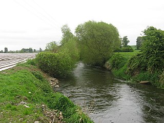
WCrossdoney is a village in County Cavan, Ireland. Situated on the R154 regional road where it terminates at a junction with the R198. Peculiarly, all buildings in the village sit on one side of the road, and this gives rise to the widely used local expression: "All to one side like Crossdoney".
 W
WDrumcarban is a townland in County Cavan, Ireland, in the electoral division of the same name. The townland lies west of the R154 regional road. Neighbouring townlands are : Cornamucklagh, Newtown, Drumbar, Coolnacarrick, Legaweel, Legaginny, Lackan Lower, and Drumcrow. On the boundary with the latter lies White Lough.
 W
WFinn McCools Fingers are a set of five standing stones on Shantemon mountain in County Cavan. The name is derived from the story that giant Celtic warrior Fionn mac Cumhaill lost a hand in battle. The stones are arranged in a south-east/north-west orientation.
WFinternagh is a townland in County Cavan, Ireland.
 W
WGartnanoul is a megalithic court tomb located in Killykeen Forest Park, Loughtee Upper, County Cavan, Ireland. Situated near Lough Oughter, the north tomb court is 3 metres in depth and 4 metres in width. Gartnanoul is called a dual-tomb because it has two tombs both in line with each other, with each tomb having its own court. It is estimated that when it was built Gartnanoul would have been 28 metres long, and 8 metres wide. The roof stones are missing although the tomb is in good condition and cairn materials are found scattered around the tomb.
 W
WThe River Glyde is a river in north-eastern Ireland, flowing from Co. Cavan to Co. Louth.
 W
WKillykeen Forest Park straddling Lough Oughter is situated in County Cavan, Ireland approximately five miles from Cavan town. Responsibility for the upkeep of Killykeen is through the state's commercial forestry service Coillte together with the National Parks and Wildlife Service (NPWS) where Lough Oughter and its associated loughs are protected under the EU Habitats Directive as a Special Area of Conservation (SAC) and a Special Protection Area (SPA) for wildlife and particularly wintering birds. The forest consists of mainly mixed woodland including Norway and Sitka spruce, Ash, Oak and Beech. The area is popular with anglers because of its location along Lough Oughter which is connected to thousands of hectares of lakeland complexes. Canoeing, biking and windsurfing are also popular activities at the park. Other Attractions include Cloughoughter Castle and Gartnanoul Court Tomb.
 W
WKilnaleck or Kilnalec is a small village in County Cavan, Ireland on the R154 regional road. Kilnaleck was once the centre of a mining boom when in 1879 some local businessmen and a school headmaster decided to develop the coal that existed nearby. However, the coal was very deep and hard to extract and the mine was forced to close. The village is part of Crosserlough parish.
WLurgan is a parish and Electoral Division, County Cavan, Ireland. Lurgan is also part of the historical barony of Castlerahan. The parish is part of the Diocese of Kilmore. The parish is also sometimes today called Virginia, after the largest town in the parish and surrounding area.
 W
WLough MacNean is a large freshwater lake on the border between Northern Ireland and the Republic of Ireland.
 W
WMilltown formerly known as Belnaleck is a village in County Cavan, Ireland. It is 7 kilometres (4.3 mi) from the town of Killeshandra and is situated near Ardan Lough and Drumlane Lough and is known for Drumlane Monastery, a sixth-century monastery and round tower located south of the village.
 W
WMoher is a townland in the Parish of Tomregan, Barony of Tullyhaw, County Cavan, Ireland.
 W
WMullanacre Lower is a townland in the Parish of Tomregan, Barony of Tullyhaw, County Cavan, Ireland.
 W
WMullanacre Upper is a townland in the Parish of Tomregan, Barony of Tullyhaw, County Cavan, Ireland.
 W
WThe R178 road is a regional road in Ireland. It runs from Dundalk, County Louth via Carrickmacross, County Monaghan and Bailieborough to Virginia, County Cavan.
 W
WThe R199 road is a regional road in Ireland linking the R198 and R202 roads in Counties Cavan and Leitrim. It is a key road for access to the Shannon–Erne Waterway.
 W
WThe R203 road is a regional road in Ireland linking Arvagh in County Cavan to Carrigallen in County Leitrim.
 W
WThe R205 road is a regional road in Ireland from the R199 road in County Leitrim to the Northern Ireland border at County Fermanagh, mostly in County Cavan. A number of factories of the former Quinn Group are located along the road.
 W
WRedhills, is a village located in northern County Cavan, Ireland. It is near the N54 road and is home to Redhills GAA club, which has produced four Cavan Inter-County players.
 W
WLough Sillan is a lough (lake) located near the town of Shercock in County Cavan, Ireland.