 W
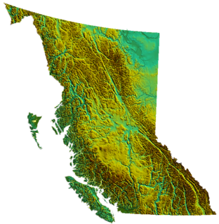
WBritish Columbia is the westernmost province of Canada, bordered by the Pacific Ocean. With an area of 944,735 square kilometres (364,764 sq mi) it is Canada's third-largest province. The province is almost four times the size of United Kingdom and larger than every U.S. state except Alaska. It is bounded on the northwest by the U.S. state of Alaska, directly north by Yukon and the Northwest Territories, on the east by Alberta, and on the south by the U.S. states of Washington, Idaho, and Montana. Formerly part of the British Empire, the southern border of British Columbia was established by the 1846 Oregon Treaty. The province is dominated by mountain ranges, among them the Canadian Rockies but dominantly the Coast Mountains, Cassiar Mountains, and the Columbia Mountains. Most of the population is concentrated on the Pacific coast, notably in the area of Vancouver, located on the southwestern tip of the mainland, which is known as the Lower Mainland. It is the most mountainous province of Canada.
 W
WMount Abbl, is a 2,012-metre (6,601 ft) mountain in the Miscinchinka Ranges of the Hart Ranges in the Northern Rocky Mountains.
WMount Aiken, is a 1,854-metre (6,083 ft) mountain in the Miscinchinka Ranges of the Hart Ranges in the Northern Rocky Mountains.
WAlexis Peak, is a 2,123-metre (6,965-feet) mountain in the Miscinchinka Ranges of the Hart Ranges in Northern British Columbia.
WMount Bracey, is a 1,954-metre (6,411 ft) mountain in the Miscinchinka Ranges of the Hart Ranges in the Northern Rocky Mountains.
 W
WCypress Mountain is a ski area in West Vancouver, British Columbia, Canada, located in the southern section of Cypress Provincial Park, operated under a BC Parks Park Use Permit.
 W
WThe Dewdney Trail is a 720 km (450 mi) trail in British Columbia, Canada that served as a major thoroughfare in mid-19th century British Columbia. The trail was a critical factor in the development and strengthening of the newly established British Colony of British Columbia, tying together mining camps and small towns that were springing up along the route during the gold rush era prior to the colony's joining Canadian Confederation in 1871. The route's importance and urgency was prompted because many new gold finds were occurring at locations near the US border that were much more easily accessed from Washington Territory than via any practicable route from the barely settled parts of the Lower Mainland and Cariboo. Today, approximately 80 percent of the former trail has been incorporated into the Crowsnest Highway.
 W
WThe Fraser Lowland is a landform and physiographic region of the Pacific Northwest, in the Canadian province of British Columbia and the U.S. state of Washington. It includes much of the Lower Mainland region of British Columbia and a portion of Whatcom County, south of the Canada–US border. The American exclave of Point Roberts lies to the region's extreme southwest. The region lies adjacent to the coast of the Strait of Georgia between Bellingham Bay and Burrard Inlet. It extends east, through the relatively flat terrain between the Cascade Range and Coast Mountains, to the eastern end of the Fraser Valley near Hope. The Fraser River is the region's primary river, but the region also includes the Nooksack River and the lowlands between the two.
 W
WThe geography of the North Cascades describes a range of rugged mountains in British Columbia, Canada and Washington, United States. In Canada, the range is officially named the Cascade Mountains but is commonly referred to as the Canadian Cascades.
WGrant Peak, is a 2,094-metre (6,870-feet) mountain in the Murray Range of the Hart Ranges in Northern British Columbia.
WLavitah Mountain, is a 1,699-metre (5,574 ft) mountain in the Miscinchinka Ranges of the Hart Ranges in the Northern Rocky Mountains.
WMilburn Peak, is a 2,019-metre (6,624-feet) mountain in the Murray Range of the Hart Ranges in Northern British Columbia.
WMorfee Lake is a lake within the Miscinchinka Ranges of Northern British Columbia and is approximately 2.93 km² (2.2 mi²) in size. It is located within the boundaries of the District of Mackenzie and is also the source of drinking water for the community.
 W
WMount Morfee, is a 1,775 metre peak in the Misinchinka Ranges, a subdivision range of the Hart Ranges, within the Northern Rocky Mountains. The mountain is known locally as Morfee Mountain and features prominently over the town Mackenzie, BC.
WMount Murray, is a 1,802-metre (5,912-feet) in the Murray Range of Hart Ranges of Northern British Columbia. The mountain is within the Pine-Lemoray Provincial Park.
WMount Myhon, is a 2,119-metre (6,952 ft) mountain in the Miscinchinka Ranges of the Hart Ranges in the Northern Rocky Mountains.
WMount Whitford is a 1,986-metre (6,516 ft) mountain in the Miscinchinka Ranges of the Hart Ranges in the Northern Rocky Mountains.
WMurray Range, is a subdivision range of the Hart Ranges, of the Northern Rockies in British Columbia, Canada. The majority of the range lies within the Pine-Lemoray Provincial Park and is noted for its snowmobiling, hiking and ski touring opportunities. The boundaries of the Murray Range generally lie between the Misinchinka River to the west and Mountain Creek to the east; the Pine River to the north and Mount Reynolds to the south.
 W
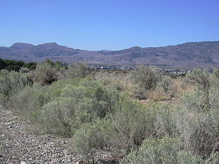
WThe Okanagan Desert is the common name for a semi-arid shrubland located in the southern region of the Okanagan Valley in British Columbia and Washington. It is centred around the city of Osoyoos and is the only semi-arid shrubland in Canada. Part of this ecosystem is referred to as the Nk'mip Desert by the Osoyoos Indian Band, though it is identical to the shrublands elsewhere in the region.
WOld Friend Mountain, is a 1,844-metre (6,050 ft) mountain in the Miscinchinka Ranges of the Hart Ranges in the Northern Rocky Mountains.
 W
WThe Purcell Trench, also known as the Kootenay River Valley is a large valley on the western side of the northern part of North America's Rocky Mountains. The trench extends approximately 179 miles (288 km) from Lake Pend Oreille, Idaho, down the Kootenay River (north) to Kootenay Lake, up the north arm to Duncan Lake. It joins the Rocky Mountain Trench another 50 miles (80 km) northward at the south tip of Kinbasket Lake, in British Columbia. The trench bottom is 1 to 7 miles wide and is 1,750 to 2,100 feet above sea level. The trench is nearly a straight north or south line. Some of its topography has been carved into U-shaped glacial valleys, it is primarily a product of geologic faulting. The trench splits the Columbia Mountains between the Purcell Mountains on the east and the Selkirk Mountains on the west.
 W
WIn the province of British Columbia in Canada, a regional district is an administrative subdivision of the province that consists of a geographic region with specific boundaries and governmental authority. As of January 2020, there were 28 regional districts in the province.
 W
WThe Tagish Lake meteorite fell at 16:43 UTC on 18 January 2000 in the Tagish Lake area in northwestern British Columbia, Canada.