 W
WAdi Kailash, also known as Shiva Kailash, Chota Kailash, Baba Kailash or Jonglingkong Peak, is a mountain located in the Himalayan mountain range in the Pithoragarh district of Uttarakhand, India.
 W
WAskot Musk Deer Sanctuary is located 54 km from Pithoragarh near Askot in Uttarakhand state of India. This sanctuary has been set up primarily with the object of conserving the musk deer (Moschus leucogaster) and its habitat. Intensive efforts have been initiated to conserve this rare species. Other mammals found in this sanctuary include the Bengal tiger, Indian leopard, Himalayan jungle cat, civet, barking deer, serow, goral and Himalayan brown bear. Many species of high altitude birds are also found in this sanctuary.
WBamba Dhura is a Himalayan mountain peak situated in the Pithoragarh district of Uttarakhand, India. With a summit altitude of 6,334 metres (20,781 ft), Bamba Dhura is situated on the north west ridge over the end of the Kalabaland Glacier in the eastern part of the district, left of the Milam Glacier. Kalabaland Dhura (6,105 m) is situated to the west of this peak and Chiring We (6,559 m) is on the same massif. Bamba Dhura massif is the part of divide between Kalabaland and Lassar valley. This peak was first climbed to the summit in 1977 from south by col between Bamba Dhura and Chiring We. The peak has since been climbed through the southeastern and western ridges between the two peaks.
WBurphu Dhura is a Himalayan mountain peak situated in the Pithoragarh district of Uttarakhand, India. The altitude of the summit is 6,334 m. It is situated at the end ridge over the Kalabaland Glacier in the eastern part of the district, left to the Milam Glacier. Kalabaland Dhura (6,105 m) is situated to the west of this peak on the same massif. Burphu Dhura massif is the part of divide between Kalabaland and Goriganga valleys. This peak was first of all climbed to summit in 2000 from south on 27 September 2000 by Loveraj Dharmashaktu, Balwant Singh Kapkoti and Ramesh by an Indian team led by Wing Cdr S S Puri. The peak has two approaches—one from the Kalabaland glacier above the icefall and another from Burphu village in the Milam valley.
 W
WChanguch is a Himalayan mountain peak situated at the boundary of Pithoragarh and Bageshwar district of the Uttarakhand state of India. This peak is situated above the Pindari Glacier. This peak offers a ridge leading to Nanda Kot. On its massif Traill's pass is situated, which connects Pindari valley to Goriganga valley. The first successful ascent to the peak was made by an Indo-British team on 9 June 2009 at 9 am.
WChaudhara is a Himalayan mountain peak, situated in the Pithoragarh district of Uttarakhand state in India. The altitude of the peak is 6,510 m. The peak lies to the south of Ralam pass and north west of Panchchuli. The peak is so named due to the peak having four corners. The peak was climbed for the first time by an Indian team led by A.R.Chandekar and Sherpa Ajeeba in 1973. Rajrambha is its neighbouring peak. Chaudhara is situated at the south east end of Kalabaland Glacier-Sankalp Glacier-Yangchar Glacier group. Chaudhara is the part of Himalayan massif between Ralam and Lassar valley. The most popular route to the summit is via the west face.
 W
WChhiplakot or Najurikot, which in local language is called Chhipuldhura, is a Himalayan mountain range that lies between the Kali River and Gori River in Pithoragarh district of Uttarakhand, India. It is bounded on the east by Nepal, on the west by Munsyari and on the north by the Himalayas, on the south by the Askot. This mountain is situated to the south of Panchachuli. The highest peak of this range is Najurikot, which is about 4497 meters above sea level. It has beautiful places full of wide range of flora and fauna, lakes and beautiful alpine meadows.
 W
WChiring We is the Himalayan peak situated in eastern Kumaun of the Pithoragarh district of Uttarakhand state in India. The altitude of the peak is 6,559 m. Chiring We is the highest peak above the Kalabaland Glacier. Chiring We massif, which include peaks like Bamba Dhura (6,334 m), Suli Top (6,300 m), Trigal (5,983 m), Suitilla (6,373 m), separates Lassar Yankti valley from Kalabaland valley. The peak literally means 'Mountain of long life'. The route is through glaciers of Kalabaland, Sankalpa and Yankchar, icefall, crevasses, ice-pinnacles, ice walls and sharp ridges. First ascent to this peak was made in 1979 by an Indian team led by Harish Kapadia via northeast ridge.
 W
WGori Ganga is a river in the Munsiari tehsil of the Pithoragarh District, part of the state of Uttarakhand in northern India. Its principal source is the Milam Glacier, just northeast of Nanda Devi along with the Glaciers of the Ralam River, and the Pyunshani and Uttari & Dakshini Balati Glaciers that lie on the western face of the Panchachuli Peaks.
WGori Ganga is a river in the Munsiari tehsil of the Pithoragarh District, part of the state of Uttarakhand in northern India. Its principal source is the Milam Glacier, just northeast of Nanda Devi along with the Glaciers of the Ralam River, and the Pyunshani and Uttari & Dakshini Balati Glaciers that lie on the western face of the Panchachuli Peaks.
 W
WHardeol or 'Temple of God' is one of the major peaks of the Kumaon Himalaya. It is the highest peak on the northern side of the ring of peaks guarding the Nanda Devi Sanctuary, and lies at the northeast corner of this ring. It is situated at the northern end of the Milam valley, in the Pithoragarh district of Uttarakhand, India. To its immediate north lies Trishuli, and just south is Rishi Pahar, on a north-south trending ridge leading eventually to Nanda Devi East. Hardeol is also known as Trishuli South.
 W
WJohar Valley is a valley located in Uttarakhand, India, along the Gori Ganga river. The valley used to be a major trade route with Tibet. The best known villages in the valley are Martoli and Milam.
 W
WMount Kuchela Dhura is a mountain located in Pithoragarh, Uttarakhand, India. It is located at the near true right bank of Lwa Glacier or true left bank of Shalang glacier, surrounded by Mount Nandakot, 6861 metres and 0.6041 metres to its south-west and north-east respectively. This peak offers a 3 km (approx.) long rutted ridge leading to Nanda Kot’s north face.
 W
WLipulekh is a Himalayan pass on the border between India's Uttarakhand state and the Tibet region of China, near their trijunction with Nepal. Nepal has ongoing claims to the southern side of the pass, called Kalapani territory, which is controlled by India. The pass is near the Chinese trading town of Taklakot (Purang) in Tibet and used since ancient times by traders, mendicants and pilgrims transiting between India and Tibet. It is also used by pilgrims to Kailas and Manasarovar.
WNagalaphu is a Himalayan mountain peak located in the Pithoragarh district of Uttarakhand state in India. It is the part of Himalayan mountain massif that divides Lassar-Darma valley and Ralam-Gori Ganga valley. Its summit reaches an altitude of 6,410 metres (21,030 ft) above sea level.
WNamik Glacier is situated in the Pithoragarh district of Uttarakhand state in India. The glacier is situated on the Kumaon Himalayas at an altitude of 3,600 m (11,800 ft). This glacier is the source of the Ramganga River. The glacier is surrounded by the following peaks: Nanda Devi 7,848 metres (25,748 ft), Nanda Kot 6,861 metres (22,510 ft), and Trishuli 7,120 metres (23,360 ft). The glacier falls on ancient Indo-Tibet trade route. It is 23 km (14 mi) trekking from Liti and situated at the villages of Gogina and Namik. There are a number of waterfalls and sulphur springs originating around this glacier. The glacier can be reached by trekking from gogina on the sama liti Road near. It is 63 kilometres (39 mi) from Bageshwar. Jeeps can be hired from Bageshwar or Kapkot up to Gogina. 'Namik' means a place where saline water springs are present.
WNanda Gond is the Himalayan mountain peak situated in the Pithoragarh district of Uttarakhand state of India. It is located in the Milam valley on the east of Milam Glacier. The altitude of the summit is 6,315 m (20,719 ft). Ikualari (6,059 m), Nanda Pal (6,306 m), Nital Thaur (6,236 m), are its neighbouring peaks. Unta Dhura Pass is located north to it.
 W
WNanda Kot is a mountain peak of the Himalaya range located in the Pithoragarh district of Uttarakhand state in India. It lies in the Kumaon Himalaya, just outside the ring of peaks enclosing the Nanda Devi Sanctuary, 15 kilometres (9 mi) southeast of Nanda Devi itself. The name Nanda Kot literally means "Nanda's Fortress" and refers to the abode of one of the sacred forms of the Hindu Goddess Parvati who in legend has made her sanctuary amongst the ring of lofty mountains in the region.
 W
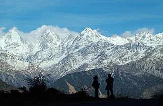
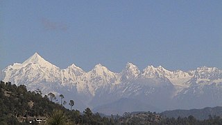
WThe Panchachuli (पंचाचुली) peaks are a group of five snow-capped Himalayan peaks lying at the end of the eastern Kumaon region, near Dugtu Village Darma valley. The peaks have altitudes ranging from 6,334 metres (20,781 ft) to 6,904 metres (22,651 ft). They form the watershed between the Gori and the Darmaganga valleys. Panchchuli is also located on the Gori Ganga-Lassar Yankti divide. The group lies 138 km (86 mi) from Pithoragarh. The first ascent of this range was done by Indo-Tibet Border Police (ITBP) team in 1972, via Uttari Balati glacier, led by Hukam Singh.
 W
WPanchchuli Glacier is a Himalayan glacier, situated in the Pithoragarh district of Uttarakhand, India. It is located in the easternmost part of Kumaun. It is in the west and east of five peaks of Panchchuli on the Johar Valley and Darma valley. Uttari Balati glacier is situated north to it.
 W
WThe Pindari Glacier is a glacier found in the upper reaches of the Kumaon Himalayas, to the southeast of Nanda Devi and Nanda Kot. The glacier is about three kilometers long and 365 meters wide and gives rise to the Pindar River which meets the Alakananda at Karnaprayag in the Garhwal district.
WRishi Pahar is a Himalayan mountain peak, located in the Pithoragarh district of Uttarakhand state in India. It lies at the northeast corner of the ring of peaks surrounding the Nanda Devi Sanctuary, and on the eastern rim of the Nanda Devi Biosphere Reserve, just south of Trishuli and Hardeol. The Milam Glacier lies on its east flank. It marks the triple divide between the Milam, Dunagiri, and Uttari Rishi Ganga valleys. Rishi Pahar means 'The Peak of Saint' in Hindi.
WTirsuli is a Himalayan mountain peak in the Pithoragarh district of Uttarakhand, India. It is part of the complex of mountains, including Tirsuli West, Hardeol, Dunagiri, Changabang, and Kalanka, which make up the northeast wall of the Nanda Devi Sanctuary, in the Garhwal Himalaya. It rises at the northern end of the Johar Valley, which drains into the Ghori Ganga. This peak should not be confused with nearby Trisul, which is on the southwest side of the Sanctuary.