 W
WA phantom island is a purported island which appeared on maps for a period of time during recorded history, but was removed from later maps after it was proven not to exist.
 W
WThe Anson Archipelago was a designation for a widely scattered group of purported islands in the Western North Pacific Ocean between Japan and Hawaii. The group was supposed to include Wake Island and Marcus Island, as well as many phantom islands such as Los Jardines, Ganges Island, Rica de Oro, and Rica de Plata. The archipelago was named after George Anson, who seized Spanish navigational charts of these waters during his voyage around the world.
 W
WAtlantis is a fictional island mentioned in an allegory on the hubris of nations in Plato's works Timaeus and Critias, where it represents the antagonist naval power that besieges "Ancient Athens", the pseudo-historic embodiment of Plato's ideal state in The Republic. In the story, Athens repels the Atlantean attack unlike any other nation of the known world, supposedly bearing witness to the superiority of Plato's concept of a state. The story concludes with Atlantis falling out of favor with the deities and submerging into the Atlantic Ocean.
 W
WBrasil, also known as Hy-Brasil or several other variants, is a phantom island said to lie in the Atlantic Ocean west of Ireland. Irish myths described it as cloaked in mist except for one day every seven years, when it becomes visible but still cannot be reached.
 W
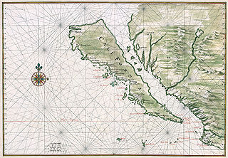
WThe Island of California refers to a long-held European misconception, dating from the 16th century, that the Baja California Peninsula was not part of mainland North America but rather a large island separated from the continent by a strait now known as the Gulf of California.
 W
WCandyn was a supposed remote east-Asian island around the turn of the 15th century.
 W
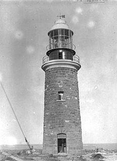
WPoint Cloates, formerly known as Cloate's Island, is a peninsula approximately 100 kilometres south south-west of North West Cape, in the Pilbara region of Western Australia. It features Point Cloates Lighthouse and the ruins of a previous lighthouse ; both buildings are on Cloates Hill, which rises 41 metres above sea level.
 W
WThe Crocker Land Expedition took place in 1913. Its purpose was to investigate the existence of Crocker Land, a huge island supposedly sighted by the explorer Robert Peary from the top of Cape Colgate in 1906. It is now believed that Peary fraudulently invented the island.
 W
WDavis Land is the name of a phantom island that was believed to be located in the Pacific Ocean, near South America. It is named for the pirate Edward Davis, who supposedly sighted it in 1687. Never found again, it was also believed by William Dampier to possibly be the coast of Terra Australis Incognita.
 W
WThe Ernest Legouve Reef is located in the South Pacific, south of French Tuamotu Islands and east of New Zealand. Krauth reports that it is situated at 35°12′S 150°40′W.
 W
WFilippo Reef is a reef that is asserted to be in the Pacific Ocean at 05°30′S 151°50′W, 450 kilometres (280 mi) east of Starbuck Island in the Line Islands. The reef was reported by the master of the Italian barque Filippo as having been seen on 28 June 1886. From an unidentified report of breakers dated 1926, it was estimated to have a water depth of only 0.6 to 0.9 metres, and appeared to be about 1.6 kilometres (1.0 mi) long northwest to southeast, and less in width.
WGanges Island, a phantom island known as Nakanotorishima in Japanese, appeared at 30°45′N 154°25′E on maps of the late 19th and early 20th centuries. Reports of its disappearance appeared in 1933.
 W
WHaymet Rocks were reported by J.E. Haymet, master and owner of the cutter Will Watch, when on passage between Auckland and Rarotonga; in 1863 the cutter passed between two rocks and struck on the northern of the two, damaging her false keel. The rocks are said to extend over a space of about a quarter of a mile, to have been distinctly seen, and with apparently 7 or 8 feet water on them. Haymet gave their position as 27°11′S 160°13′W, which would place them about 135 miles west of the position assigned to Orne Bank.
 W
WLa grande isle de Java was, according to Marco Polo, the largest island in the world; his Java Minor was the actual island of Sumatra, which takes its name from the city of Samudera situated on its northern coast.
 W
WJuan de Lisboa is a phantom island in the Western Indian Ocean allegedly located southeast of Madagascar. It was reported on maps and charts of the 17th and 18th centuries, sometimes depicted alongside another phantom island, dos Romeiros.
WJupiter Reef or Jupiter Breakers is a supposed reef in the South Pacific, between other supposed reefs, Maria Theresa Reef to the south and Ernest Legouve Reef to the north; it appears to be a phantom reef.
 W
WLos Jardines or Los Buenos Jardines are phantom islands supposedly located northeast of the Mariana Islands.
WThe Maria Theresa Reef is a supposed reef in the South Pacific ; it appears to be a phantom reef. It is also known as Tabor Island or Tabor Reef on French maps.
 W
WIsle Phelipeaux or Isle Philippeaux – also called Isle Minong – is a phantom island supposedly located in Lake Superior. In the late 18th and early 19th centuries, it was believed to be real, and was shown on maps of the era. The island "Phelipeaux" is mentioned in the 1783 Treaty of Paris as a landmark defining the border between the United States and what would later become Canada.
 W
WRivadeneyra Shoal is a shoal or seamount in the Eastern Pacific Ocean between Malpelo Island and Cocos Island. It was reported in October 1842 at the position 4°15′N 85°10′W with a depth of 10 feet. It was unsuccessfully searched for by the British war vessels HMS Cockatrice and HMS Havannah in 1854 and 1857 respectively, and by the USS Mohican in 1885.
 W
WSandy Island is a non-existent island that was charted for over a century as being located near the French territory of New Caledonia between the Chesterfield Islands and Nereus Reef in the eastern Coral Sea. The island was included on many maps and nautical charts from as early as the late 19th century. It was removed from French hydrographic charts in 1974. The island gained wide media and public attention in November 2012 when the R/V Southern Surveyor, an Australian research ship, passed through the area and "undiscovered" it. The island was quickly removed from many maps and data sets, including those of the National Geographic Society and Google Maps.
 W
WTerra Australis was a hypothetical continent first posited in antiquity and which appeared on maps between the 15th and 18th centuries. The existence of Terra Australis was not based on any survey or direct observation, but rather on the idea that continental land in the Northern Hemisphere should be balanced by land in the Southern Hemisphere. This theory of balancing land has been documented as early as the 5th century on maps by Macrobius, who uses the term Australis on his maps.
WCaptain Lambert of the ship Wachusett reported that on June 4, 1899 he passed over a reef which appeared to be of coral formation in approximately latitude 32°18′S 151°08′W. The reef appeared to be about 500 feet wide. The bottom showed of a dark gray color with deep blue on both sides of the reef. The depth was estimated at from 5 to 6 fathoms; unfortunately no soundings were taken.