 W
WAmerikakaj is a 700 metre long quay along the west side of the Søndre Frihavn dock in Copenhagen, Denmark. The name commemorates the transatlantic passenger ships of the Scandinavian America Line which used to berth along the quay during the first half of the 20th century. Today DFDS's ferries to Oslo berth at its north end.
 W
WÅrhusgade is a street in the Østerbro district of Copenhagen, Denmark. It extends east from Østerbrogade and passes under the railway just before entering the southernmost part of Nordhavn which is known as the Århusgade neighbourhood after it. The street has many cafés and small shops. The street is named after the City of Aarhus, the second largest city in Denmark.
 W
WBlegdamsvej is a street in Copenhagen, Denmark, connecting Sankt Hans Torv in Nørrebro to Trianglen in Østerbro. The busy artery Fredensgade separates the Nørrebro and Østerbro sections of the street from each other. The north side of the street is dominated by the Panum Building and Rigshospitalet, located on either side of Tagensvej.
 W
WClassensgade is a street in the Østerbro district of Copenhagen, Denmark. It runs from Østerbrogade in the southwest to Østbanegade in the northeast.
 W
WGunnar Nu Hansens Plads is a public space in the Østerbro district of Copenhagen, Denmark. It consists of a triangular plaza, located on the west side of Østerbrogade, just north of Parken Stadium, which turns into a wide street and continues for about 200 m to Fælledparken, The street then continues southwest as Per Henrik Lings Allé to Øster Allé. Several sports venues, some of which are listed, are located on the south side of the square. The former Østerfælled Barracks, now a mixed-use development known as Østerfælled Torv, are located on its north side.
 W
WHaraldsgade is an approximately 1.1 km long street in the outer Nørrebro and Østerbro districts of Copenhagen, Denmark. It runs from Tagensvej in the southwest to Lyngbyvej in the northeast. Skjolds Plads Station, a station on the Copenhagen Metro City Circle Line, is located at the beginning of the street. The station takes its name after Skjolds Plads, a small square located off the east side of the street. The southwestern end of the street was closed to through traffic in connection with the opening of the metro station.
 W
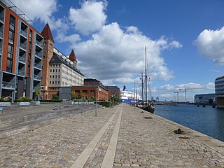
WIndiakaj is a quay and adjacent street which marks the southern boundary of the Søndre Frihavn area of Copenhagen, Denmark. It originates in the west at Kalkbrænderihavnsvej and continue east to a roundabout at the base of Langelinie PPierer.
 W
WJagtvej is a major artery in the Nørrebro and Østerbro districts of Copenhagen, Denmark. It runs from Agade on the border with Frederiksberg in the southwest to Østerbrogade in the northeast, linking Falkoner Allé with Strandboulevarden. The street passes Assistens Cemetery, University of Copenhagen's North Campus and Fælled Park.
 W
WKastelsvej is a street in the Østerbro district of Copenhagen, Denmark. It runs from Classensgade to Strandboulevarden.
 W
WKristianiagade is a street located close to Østerport station in the Østerbro district of Copenhagen, Denmark. Buildings in the street include Domus Medica, a former noble town mansion which now houses the Danish Medical Association. The west side of the street is mostly lined with late 19th century villas of which several now serve as embassies.
 W
WNordre Frihavnsgade is a street in the Østerbro district of Copenhagen, Denmark, linking the junction Trianglen in the southwest with Østbanegade In the northeast. The street passes the two small squares Victor Borges Plads and Melchiors Plads. An underpass under the raised railway tracks at the end of the street provides access to Nordhavn's Århusgade neighbourhood.
 W
WNørre Alle is a street in Copenhagen, Denmark, running from Blegdamsvej in Nørrebro in the south to Vibenshus Runddel in Østerbro in the north. It runs through University of Copenhagen's North Campus which is centred on its junction with Tagensvej. The section north of the junction, which separates Fælledparken to the east from the University Park to the west, is a busy artery. De Gamles By is situated on the west side of the more quiet, western portion.
 W
WØstbanegade is a street in Copenhagen, Denmark. It begins at Østerport Station on Oslo Plads and continues north along the west side of the railway tracks for about 2 kilometres to Aarhusgade where an underpass connects the street to the other side of the railway line. A second underpass is situated at Nordre Frihavnsgade, just south of Nordhavn station, while a foot and cycle bridge is found at Mandalsgade near the beginning of the street.
 W
WØster Allé is a street in the Østerbro district of Copenhagen, Denmark, connecting Trianglen to Vibenhus Runddel. The northern part of the street, after Parken Stadium, Denmark's national football stadium, bisects Fælledparken, Copenhagen's largest park.
 W
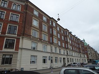
WØsterbrogade is the principal shopping street and thoroughfare in the Østerbro district of Copenhagen, Denmark. It extends from Lille Triangel at the north-eastern tip of The Lakes, passes Trianglen, and continues to Svanemøllen station from where it becomes Strandvejen.
 W
WRandersgade is a street in the Østerbro district of Copenhagen, Denmark, linking Nordre Frihavnsgade in the south to Strandboulevarden in the north. The small square Bopas Plads is located on the corner of Randersgade with Viborggade.
 W
WRyesgade is a street straddling the border of the Nørrebro and Østerbro districts of Copenhagen, Denmark. Together with Ravnsborggade, its continuation to the south, it forms the backbone of a small neighbourhood bounded by The Lakes to the east, Blegdamsvej to the west, Nørrebrogade to the south and Østerbrogade to the north. The busy artery Fredensgade and the adjacent Fredens Park, effectively separates the Nørrebro and Østerbro portions of Ryesgade from each other. Ryesgade was formerly known for its many second-hand stores of which a few still exist today.
 W
WSankt Jakobs Plads is a public square located off the east side of Østerbrogade in the Østerbro district of Copenhagen, Denmark. It takes its name after St. James' Church on the other side of the street.
 W
WSortedam Dossering is a street that follows the western shore of Sortedam Lake, from Nørrebrogade in the south to Østerbrogade in the north, in central Copenhagen, Denmark. The section north of Helgesensgade is closed to cars. The section from Nørrebrogade to Fredensgade is in Nørrebro while the section from Fredensgade to Østerbrogade belongs to Østerbro.
 W
WStrandboulevarden is a major street in the Østerbro district of Copenhagen, Denmark. It runs from Fridtjof Nansens Plads as in the south to Østerbrogade in the north, linking Kristianiagade with Jagtvej.
 W
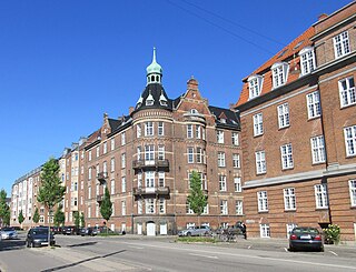
WTrianglen is a central junction and public space in the Østerbro district of Copenhagen, Denmark. Five streets meet in the junction: Blegdamsvej, Øster Allé, Østerbrogade, Nordre Frihavnsgade and Odensegade. Trianglen is a station on the City Circle Line of the Copenhagen Metro.
 W
WViborggade is a street in the Østerbro district of Copenhagen, Denmark, linking Østerbrogade in the west with Strandboulevarden in the east. The street is closed to through traffic at Bopa Plads, a small square located at the intersection with Randersgade.
 W
WVictor Borges Plads is a public square in the Østerbro district of Copenhagen, Denmark. It is located on Nordre Frihavnsgade, roughly halfway between Trianglen and Strandboulevarden, and has several restaurants and cafés with outdoor service.