 W
WAncón de Sardinas is a bay in the Pacific Ocean, located on the border between Colombia, which is to the north, and Ecuador, which is to the south. In this place begins the maritime delimitation of the border between Colombia and Ecuador, which consists of a single treaty signed on August 23, 1975 and, from the intersection of the extension of the land border and the confluence of the territorial areas of both countries, a midpoint is marked in the bay; From here to the Mataje River, which flows into it, a line is drawn that terminates the boundary.
 W
WAzufral is a stratovolcano located in the department of Nariño in southern Colombia, 12 km (7 mi) west of the town of Túquerres. It is the only volcano of the Western Ranges of the Colombian Andes. Its name derives from the Spanish word for sulfur, azufre. The volcano is considered semi-dormant but there are numerous fumaroles in the summit crater. The summit of the volcano has an altitude of 4,070 metres (13,350 ft), and the north-western side of the crater contains a crescent-shaped lake named Laguna Verde at 3,970 m (13,025 ft). The lake is 1,100 m (0.68 mi) long and 600 metres (2,000 ft) wide. and its bright green color is a result of the sulfur and iron-based deposits in the crater. There are also two other much smaller lakes in the crater, Laguna Negra and Laguna Cristal.
 W
WBosque Seco del Patía Fauna and Flora Sanctuary, or Patia Dry Forest, is a wildlife sanctuary in Colombia. It is located on the border between the Nariño Department and the Cauca Department.
 W
WChiles is a volcano on the border of Colombia and Ecuador. It lies 3 kilometres (2 mi) south-east of the volcano Cerro Negro de Mayasquer, and the two peaks are considered part of the same Chiles-Cerro Negro volcanic complex. The volcanoes, together with the Cumbal are andesitic in rock type. A 1936 eruption reported by the Colombian government agency Ingeominas may have been from the Ecuadorean volcano Reventador, otherwise the volcano has not erupted for around 160,000 years.
 W
WCumbal is a stratovolcano of the Caribe Terrane, located at the Nudo de los Pastos in Nariño, Colombia. It is the southernmost historically active volcano of Colombia and is together with Chiles and Azufral one of the few volcanoes of the Western Ranges. The volcano is dominated by andesites.
 W
WDoña Juana is a stratovolcano, located within the Doña Juana-Cascabel Volcanic Complex National Natural Park in Nariño, Colombia.
WDoña Juana-Cascabel Volcanic Complex National Natural Park is a Colombian National Natural Park. The park is located in the Southern Departments of Nariño and Cauca; The park is named after three volcanoes which are Doña Juana, Petacas and Las Ánimas. These are in the municipalities of El Tablón, San Bernardo, La Cruz, San Pablo in Nariño Department, and Bolívar, Santa Rosa in the Cauca Department.
WThe Buesaco-Aranda Fault is a dextral strike-slip fault in the department of Nariño in southwestern Colombia. The fault has a total length of 29 kilometres (18 mi) and runs along an average northeast to southwest strike in the Central Ranges of the Colombian Andes. The 1995 Pasto earthquake is associated with the active fault showing high amounts of displacement. The earthquake caused seven fatalities.
WThe Eastern Frontal Fault System is a megaregional system of oblique and thrust faults cross-cutting Colombia from Ecuador in the south to Venezuela in the north. The system from south to north covers ten out of 32 departments of Colombia; Nariño, Putumayo, Cauca, Huila, Caquetá, Cundinamarca, Meta, Boyacá, Casanare and Arauca. The Eastern Frontal Fault System underlies and affects the capitals of Putumayo, Mocoa, Caquetá, Florencia, Meta, Villavicencio and Casanare, Yopal. The fault system has a total length of 921.4 kilometres (572.5 mi) with a cumulative length of the faults of 1,821.8 kilometres (1,132.0 mi) and runs along an average northeast to southwest strike of 042.1 ± 19 bordering and crossing the Eastern Ranges of the Colombian Andes. The fault system forms the boundary between the North Andes microplate and the South American Plate.
WThe Guáitara Fault is a dextral strike-slip fault in the department of Nariño in southwestern Colombia. The fault has a total length of 36.1 kilometres (22.4 mi) and runs along an average northeast to southwest strike of 044.1 ± 4 in the Western Ranges of the Colombian Andes.
WThe Piedrancha Fault is a dextral oblique strike-slip fault in the department of Nariño in southwestern Colombia. The fault has a total length of 79.5 kilometres (49.4 mi) and runs along an average northeast to southwest strike of 033.8 ± 14 in the Western Ranges of the Colombian Andes.
WThe Remolino-El Charco Fault is a dextral strike-slip fault in the department of Nariño in Colombia. The fault has a total length of 148.7 kilometres (92.4 mi) and runs along an average northeast to southwest strike of 046.4 ± 6 in the Tumaco Basin along the Pacific Coast of Colombia.
 W
WGaleras is an Andean stratovolcano in the Colombian department of Nariño, near the departmental capital Pasto. Its summit rises 4,276 metres (14,029 ft) above sea level. It has erupted frequently since the Spanish conquest, with its first historical eruption being recorded on December 7, 1580. A 1993 eruption killed nine people, including six scientists who had descended into the volcano's crater to sample gases and take gravity measurements in an attempt to be able to predict future eruptions. It is currently the most active volcano in Colombia.
 W
WJunín is a settlement in Barbacoas Municipality, Nariño Department in Colombia.
WLas Ánimas is a volcano of the Central Ranges of the Colombian Andes at the border of the departments of Cauca and Nariño. The volcano is 4,175 metres (13,698 ft) high.
 W
WThe Malpelo Plate is a small tectonic plate (microplate) located off the coasts west of Ecuador and Colombia. It is the 57th plate to be identified. It is named after Malpelo Island, the only emerged part of the plate. It is bounded on the west by the Cocos Plate, on the south by the Nazca Plate, on the east by the North Andes Plate, and on the north by the Coiba Plate, separated by the Coiba Transform Fault (CTF). This microplate was previously assumed to be part of the Nazca Plate. The Malpelo Plate borders three major faults of Pacific Colombia, the north to south striking Bahía Solano Fault in the north and the Naya-Micay and Remolino-El Charco Faults in the south.
WMedicinal Plants Orito Ingi-Ande Flora Sanctuary is the newest protected area in Colombia. The sanctuary is localized in Southern Colombia, Departments of Putumayo and Nariño in the municipalities of Orito (Putumayo) and Funes & Pasto in (Nariño) south side of Cerro Patascoy. In this area they keep medical plants from harm and destruction.
 W
WCerro Negro de Mayasquer is a volcano on the border of Colombia and Ecuador. It lies 3 kilometres (2 mi) north-west of the volcano Chiles, and the two peaks are considered part of the same Chiles-Cerro Negro volcanic complex. These volcanoes, together with Cumbal are andesitic in rock type. A 1936 eruption reported by the Colombian government agency INGEOMINAS may have been from the Ecuadorean volcano Reventador, otherwise the volcano has not erupted for around 160,000 years.
 W
WNudo de los Pastos, in English meaning "Knot of the Pastos" or also known as the "Massif of Huaca", is an Andean orographic complex located in the Ecuadorian province of Carchi and the Colombian department of Nariño. It covers the intricate mountain region where the Andes splits into two branches on entering Colombia: the Cordillera Occidental and the Cordillera Central.
WPetacas is a lava dome in the departments of Cauca and Nariño, Colombia.
WThe Romeral Fault System is a megaregional system of major parallel and anastomosing faults in the Central Ranges of the Colombian Andes and the Cauca, Amagá, and Sinú-San Jacinto Basins. The system spans across ten departments of Colombia, from northeast to south Bolívar, Sucre, Córdoba, Antioquia, Caldas, Risaralda, Quindío, Valle del Cauca, Cauca and Nariño. The fault zone extends into Ecuador where it is known as the Peltetec Fault System. The in detail described part of the Romeral Fault System south of Córdoba has a total length of 697.4 kilometres (433.3 mi) with a cumulative length of 1,787.9 kilometres (1,110.9 mi) and runs along an average north to south strike of 017.6 ± 16, cross-cutting the central-western portion of Colombia.
 W
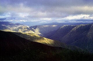
WThe Sickle of Minamá is a deep depression located in southwestern Colombia, in the territories of the Nariño and Cauca Departments, created by the Patía River at its outlet to the Pacific Ocean, and is part of the upper valley Patía.
WThe Caribbean Terrane is one of the geological provinces (terranes) of Colombia. The terrane, dating to the Late Cretaceous, is situated on the North Andes Plate and borders the La Guajira, Chibcha and underlying Tahamí Terrane along the regional Bucaramanga-Santa Marta Fault. The terrane overlies the Tahamí, Arquía and Quebradagrande Terranes along the Romeral Fault System.
WThe Tahamí or Tahamí-Panzenú Terrane is one of the geological provinces (terranes) of Colombia. The terrane, dating to the Permo-Triassic, is situated on the North Andes Plate. The contact with the Chibcha, Arquía and Quebradagrande Terranes is formed by the megaregional Romeral Fault System. A tiny terrane is located at the contact with the Quebradagrande Terrane; Anacona Terrane.