 W
WNational Grassland is a classification of protected and managed federal lands in the United States authorized by Title III of the Bankhead–Jones Farm Tenant Act of 1937. For administrative purposes, they are essentially identical to United States National Forests, except that grasslands are areas primarily consisting of prairie. Like National Forests, National Grasslands may be open for hunting, grazing, mineral extraction, recreation and other uses. Various National Grasslands are typically administered in conjunction with nearby National Forests.
 W
WThe Black Kettle National Grassland, in Roger Mills County, Oklahoma and Hemphill County, Texas, contains 31,286 acres (12,661 ha) of which 30,710 acres (12,430 ha) are in Oklahoma.
 W
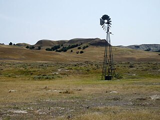
WBuffalo Gap National Grassland is a National Grassland located primarily in southwestern South Dakota, United States. It is also the second largest National Grassland, after Little Missouri National Grassland in North Dakota. Characteristics of the grasslands include mixed prairie and chalky badlands. The grassland is managed by the U.S. Forest Service and is a division of Nebraska National Forest. In descending order of land area it is located in parts of Fall River, Pennington, Jackson, and Custer counties.
 W
WButte Valley National Grassland is a 18,425-acre (7,456 ha) United States National Grassland located in northern California. Administered by the United States Forest Service, Klamath National Forest, it is located in northern Siskiyou County, near the Oregon border, between the communities of Dorris and Macdoel along U.S. Highway 97. It was dedicated in July 1991 as the nation's 20th National Grassland. It is administered as part of the Klamath National Forest, and is the sole National Grassland in California and in Region 5 of the Forest Service. Administrative offices are located in Macdoel, California.
 W
WCaddo National Grassland is a national grassland in the southern Great Plains, consisting of two separate sections located in northeastern and southeastern Fannin County, Texas, United States. It is a 17,873-acre (7,233 ha) protected area that was purchased in the 1930s. The goal of the park when purchased was to restore the eroded soil. Two developed recreation areas are around Lake Davy Crockett, which is 388 acres (157 ha) in size. The grassland is divided into two units: Bois d'Arc Creek and Ladonia.
 W
WCedar River National Grassland is a National Grassland located in Sioux County and Grant County in southern North Dakota, United States. It has a land area of 6,717 acres (2,718 ha). The portion in Sioux County lies within the Standing Rock Indian Reservation. Within the grassland are topographic features such as level plains and rolling hills. Dry streams and some small flowing streams exist throughout the Grasslands.
 W
WCimarron National Grassland is a National Grassland located in Morton County, Kansas, United States, with a very small part extending eastward into Stevens County. Cimarron National Grassland is located near Comanche National Grassland which is across the border in Colorado. The grassland is administered by the Forest Service together with the Pike and San Isabel National Forests and the Comanche National Grassland, from common headquarters located in Pueblo, Colorado. There are local ranger district offices in Elkhart, Kansas. The grassland is the largest area of public land in the state of Kansas.
 W
WComanche National Grassland is a National Grassland located in southeastern Colorado, United States. It is the sister grassland of Cimarron National Grassland and contains both prairie grasslands and canyons. It is separated into two sections, each operated by a local ranger district, one of which is in Springfield and the other of which is in La Junta. The grassland is administered by the Forest Service together with the Pike and San Isabel National Forests, and the Cimarron National Grassland, from common headquarters located in Pueblo, Colorado.
 W
WCrooked River National Grassland is a National Grassland located in Jefferson County in the north-central part of the U.S. state of Oregon. It has a land area of 173,629 acres (70,265 ha). It contains two National Wild and Scenic Rivers, the Deschutes River and the Crooked River. The grassland is managed together with the Ochoco National Forest from Forest Service offices in Prineville. There are local ranger district offices located in Madras, its nearest city.
 W
WCurlew National Grassland is a National Grassland located in Oneida and Power counties in the state of Idaho, USA. It has a land area of 47,790 acres (19,340 ha). The land used to make the grassland was purchased between the years 1934 and 1942. The primary goal of the grassland was to improve soil and vegetation in the area. The grassland is administered by the Forest Service together with the Caribou-Targhee National Forest from common headquarters located in Idaho Falls, Idaho. There are local ranger district offices in Malad City.
 W
WFort Pierre National Grassland is a United States National Grassland in central South Dakota, south of the capital city Pierre and its neighbor Fort Pierre. The national grassland is primarily a short grass prairie and has a land area of 115,890 acres (46,900 ha). In descending order of area it lies in parts of Lyman, Stanley, and Jones counties. Part of the movie Dances with Wolves was filmed there. It is managed by the U.S. Forest Service together with the Nebraska and Samuel R. McKelvie National Forests and the Buffalo Gap and Oglala National Grasslands from common offices in Chadron, Nebraska. There is a local ranger district office located in Pierre.
 W
WGrand River National Grassland is a National Grassland in northwestern South Dakota, United States. It is named for the Grand River. The North and South forks of the rivers meet in the grassland. It has a land area of 154,783 acres (62,638 ha). In descending order of acreage it lies in parts of Perkins, Corson, and Ziebach counties. The portion in Corson County also lies within the Standing Rock Indian Reservation. The portion in Ziebach County also lies within the Cheyenne River Indian Reservation.
 W
WKiowa National Grassland is a National Grassland, located in northeastern New Mexico. The southwestern Great Plains grassland includes prairie and part of the Canadian River Canyon.
 W
WLittle Missouri National Grassland is a National Grassland located in western North Dakota, USA. At 1,028,051 acres (416,037 ha), it is the largest grassland in the country. Enclaved within its borders is Theodore Roosevelt National Park, which is managed by the National Park Service. The Little Missouri National Grassland was once a part of the Custer National Forest, but is now a part of the Dakota Prairie Grasslands, a National Forest unit consisting entirely of National Grasslands. A predominant feature of the grassland is colorful and beautiful badlands, a rugged terrain extensively eroded by wind and water. It is a mixed grass prairie, meaning it has both long and short grass.
 W
WLyndon B. Johnson (LBJ) National Grassland is a national grassland located in the Great Plains of the northern part of the U.S. state of Texas near Decatur, and within an hour's drive from Fort Worth. It is primarily used for recreation, such as hiking, camping, horseback riding, fishing, and hunting. It is also used as grazing land for cattle and other livestock.
 W
WMcClellan Creek National Grassland is a National Grassland located in southern Gray County, Texas, United States. It was purchased with the goal of restoring badly eroded land to its natural state. The grassland is administered by the U.S. Forest Service together with Cibola National Forest and Black Kettle, Kiowa, and Rita Blanca National Grasslands, from common headquarters located in Albuquerque, New Mexico. The grassland is part of the combined Black Kettle and McClellan Creek Ranger District with offices in Cheyenne, Oklahoma.
 W
WThe Midewin National Tallgrass Prairie (MNTP) is a tallgrass prairie reserve and United States National Grassland operated by the United States Forest Service. The first national tallgrass prairie ever designated in the U.S. and the largest conservation site in the Chicago Wilderness region, it is located on the site of the former Joliet Army Ammunition Plant between the towns of Elwood, Manhattan and Wilmington in northeastern Illinois. Since 2015, it has hosted a conservation herd of American bison to study their interaction with prairie restoration and conservation.
 W
WThe Neal Smith National Wildlife Refuge is a federal national wildlife refuge located in Jasper County, Iowa, United States. The refuge, formerly known as Walnut Creek, is named after Congressman Neal Edward Smith, who championed its creation. It seeks to restore the tallgrass prairie and oak savanna ecosystems that once covered most of Iowa. It has a herd of approximately 50 buffalo (bison) and 20 elk.
 W
WThe Oglala National Grassland is a United States National Grassland in the northwest corner of Nebraska. It is in northern Sioux and northwestern Dawes counties, on the borders with South Dakota and Wyoming. It is 94,520 acres (38,250 ha) in size and is one of the small handful of National Grasslands administered by the US Department of Agriculture's Forest Service. It is managed by the U.S. Forest Service together with the Nebraska and Samuel R. McKelvie National Forests and the Buffalo Gap and Fort Pierre National Grasslands from common offices in Chadron, Nebraska.
 W
WPawnee National Grassland is a United States National Grassland located in northeastern Colorado on the Colorado Eastern Plains. The grassland is located in the South Platte River basin in remote northern and extreme northeastern Weld County between Greeley and Sterling. It comprises two parcels totaling 193,060 acres (78,130 ha) largely between State Highway 14 and the Wyoming border. The larger eastern parcel lies adjacent to the borders of both Nebraska and Wyoming. It is administered in conjunction with the Arapaho-Roosevelt National Forest from the U.S. Forest Service office in Fort Collins, with a local ranger district office in Greeley.
 W
WPicture Canyon, located in the Comanche National Grassland in southeastern Colorado, was named for its prehistoric rock art. There is evidence of prehistoric inhabitation of sites in Picture Canyon by Paleo-Indian, Archaic and Post-Archaic cultures, from about 12,000 years ago to 400 years ago. In addition to rock art, there are also carvings in walls that are used to identify the entry into fall and spring equinoxes.
 W
WRita Blanca National Grassland is a National Grassland on the Great Plains near the community of Texline in northwest Dallam County, Texas, in the Texas Panhandle, and in southern Cimarron County, Oklahoma, in the western Oklahoma Panhandle. The principal city in the area is Dalhart, Texas, which houses the XIT Museum.
 W
WSheyenne National Grassland is a National Grassland located in southeastern North Dakota in the United States, comprising 70,446 acres (28,508 ha) of public land amid 64,769 acres (26,211 ha) of privately owned land in a region of sandy soils in the vicinity of the Sheyenne River in Ransom and Richland Counties. It is the only National Grassland in the tallgrass prairie region of the U.S. The grassland provides habitat for the largest population of greater prairie chickens in North Dakota, as well as the Dakota skipper butterfly, the western prairie fringed orchid, and numerous ferns, as well as grazing land for approximately 83 cattle ranchers.
 W
WThe Thunder Basin National Grassland is located in northeastern Wyoming in the Powder River Basin between the Big Horn Mountains and the Black Hills. The Grassland ranges in elevation from 3,600 feet (1,100 m) to 5,200 feet (1,600 m), and the climate is semi-arid. The Grassland provides opportunities for recreation, including hiking, sightseeing, hunting, and fishing. There are no developed campgrounds; however, camping is allowed. Land patterns are very complex because of the intermingled federal, state, and private lands.