 W
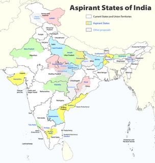
WThe constitutional power to create new states and union territories in India is solely reserved to the Parliament of India. Parliament can do so by announcing new states/union territories, separating territory from an existing state or merging two or more states/union territories or parts of them. In addition to the existing twenty eight states and eight union territories, some new states and union territories of India have at various times been proposed to be established.
 W
WAwadh, known in British historical texts as Avadh or Oudh, is a region in the modern Indian state of Uttar Pradesh, which was before independence known as the United Provinces of Agra and Oudh. Awadh is bounded by the Ganges Doab to the southwest, Rohilkhand to the northwest, Nepal to the north, and Purvanchal to the east. Its inhabitants are referred to as Awadhis.
 W
WAmra Bangali (AMB) is a political party in India, based on the socio-economic and political philosophy Progressive Utilization Theory given by Prabhat Ranjan Sarkar; the party was sparked off in reaction against anti-Bengali rhetoric in Northeast India. Amra Bangali enjoyed a short stint in the spotlight in the mid-1980s when it even won some gram panchayat seats in border districts. Today, AMB is involved in various movements and protests including those against the Darjeeling Gorkhas calling for the creation of new state of Gorkhaland.
WThe constitutional power to create new states and union territories in India is solely reserved to the Parliament of India. Parliament can do so by announcing new states/union territories, separating territory from an existing state or merging two or more states/union territories or parts of them. In addition to the existing twenty eight states and eight union territories, some new states and union territories of India have at various times been proposed to be established.
 W
WThe Bodoland Territorial Region is an autonomous region in Assam, Northeast India. It made up of four districts on the north bank of the Brahmaputra river, by the foothills of Bhutan and Arunachal Pradesh. It is administered by an elected body known as the Bodoland Territorial Council which came into existence under the terms of a peace agreement signed in February 2003 and its autonomy was further extended by an agreement signed in January 2020. The region covers an area of over eight thousand square kilometres and is predominantly inhabited by the Bodo people and other indigenous communities of Assam.
 W
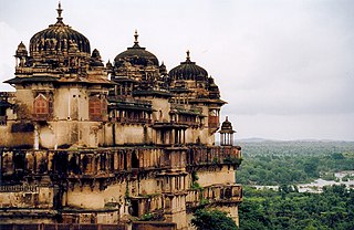
WBundelkhand is a geographical and cultural region and also a mountain range in central & North India. The hilly region is now divided between the states of Uttar Pradesh and Madhya Pradesh, with the larger portion lying in the latter state.
 W
WCoastal Andhra is a region in the state of Andhra Pradesh, India. It was part of Madras State before 1953 and Andhra State from 1953 to 1956. According to the 2011 census, it has an area of 95,442 square kilometres (36,850 sq mi) which is 57.99% of the total state area and a population of 34,193,868 which is 69.20% of Andhra Pradesh state population. This area includes the coastal districts of Andhra Pradesh on the Coromandel Coast between the Eastern Ghats and the Bay of Bengal, from the northern border with Odisha to Pulicat lake in the South.
 W
WCooch Behar district is a district of the state of West Bengal, India, as well as the district's namesake town. During the British Raj, the town of Cooch Behar was the seat of a princely state of Koch Bihar, ruled by the Koch dynasty.
 W
WDelhi, officially known as the National Capital Territory (NCT) of Delhi, is a city and a union territory of India containing New Delhi, the capital of India. It is bordered by the state of Haryana on three sides and by Uttar Pradesh to the east. The NCT covers an area of 1,484 square kilometres (573 sq mi). According to the 2011 census, Delhi's city proper population was over 11 million, the second-highest in India after Mumbai, while the whole NCT's population was about 16.8 million. Delhi's urban area is now considered to extend beyond the NCT boundaries, and include the neighbouring satellite cities of Ghaziabad, Faridabad, Gurgaon and Noida in an area called the National Capital Region (NCR) and had an estimated 2016 population of over 26 million people, making it the world's second-largest urban area according to the United Nations. Recent estimates of the metro economy of its urban area have ranked Delhi either the most or second-most productive metro area of India. Delhi is the second-wealthiest city in India after Mumbai and is home to 18 billionaires and 23,000 millionaires. Delhi ranks fifth among the Indian states and union territories in human development index. Delhi has the second-highest GDP per capita in India. Delhi is of great historical significance as an important commercial, transport, and cultural hub, as well as the political centre of India.
 W
WThe Gorkhaland movement is a campaign to create a separate state of India in the Gorkhaland region of West Bengal. The proposed state includes the hill regions of the Darjeeling district, Kalimpong district and Dooars regions that included Jalpaiguri, Alipurduar and parts of Coochbihar districts. A demand for a separate administrative unit in Darjeeling has existed since 1909, when the Hillmen's Association of Darjeeling submitted a memorandum to Minto-Morley Reforms demanding a separate administrative setup.
 W
WKamtapur was a Koch Rajbanshi kingdom in present India, Bangladesh and Nepal. The medieval Kamatapur, or Kamata kingdom, grew before the emergence of the Koch dynasty under the leadership of Viswa Singha.
 W
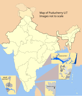
WKaraikal district is one of the four districts of the Union Territory of Puducherry in India.
 W
WNorth Karnataka is a geographical region consisting of mostly semi-arid plateau from 300 to 730 metres elevation that constitutes the northern part of the Karnataka state in India. It is drained by the Krishna River and its tributaries the Bhima, Ghataprabha, Malaprabha, and Tungabhadra. North Karnataka lies within the Deccan thorn scrub forests ecoregion, which extends north into eastern Maharashtra.
 W
WKodagu is an administrative district in the Karnataka state of India. Before 1956, it was an administratively separate Coorg State, at which point it was merged into an enlarged Mysore State. It occupies an area of 4,102 square kilometres (1,584 sq mi) in the Western Ghats of southwestern Karnataka. In 2001 its population was 548,561, 13.74% of which resided in the district's urban centre, making it the least populous of the 30 districts in Karnataka.The nearest railway stations are Mysore Junction, located around 95 km away and Thalassery and Kannur in Kerala, at a distance of 79 km. The nearest airports are Kannur International Airport in Kerala and Mangalore International Airport.
 W
WMahakoshal is a region of central India. Mahakoshal lies in the upper or eastern reaches of the Narmada River valley in the Indian state of Madhya Pradesh. Jabalpur is the largest city in the region. Nimar region lies to the west, in the lower reaches of the Narmada valley.
 W
WMithila is a proposed state in India, comprising the Maithili speaking region of Bihar and Jharkhand. The Maithili language has own traditional script, known as Mithilakshar. It is part of the historical Mithila region. The proposed state will also include some Angika and Bajjika speaking districts which are considered by some to be dialects of Maithili. What will be the capital city of Mithila, India is still to be decided.
 W
WPanun Kashmir is a proposed union territory of India in the Kashmir Valley, which is intended to be a homeland for Kashmiri Hindus.
 W
WPurvanchal is an important geographic subregion of Uttar Pradesh and Bihar that is within the larger Bhojpuri region. It comprises the eastern end of Uttar Pradeshand.
 W
WRayalaseema is a geographic region in the Indian state of Andhra Pradesh. It comprises four southern districts of the state namely, Anantapur, Chittoor, Kadapa and Kurnool. As of 2011 census of India, the region with four districts had a population of 15,184,908 and covers an area of 67,526 km2 (26,072 sq mi).
 W
WTipraland is the name of a proposed state in India for the Tripuri people who inhabit the Tripura Indigenous Areas.
 W
WTulu Nad, also called as Parashurama Srishti, is a region on the southwestern coast of India. The Tulu people, known as 'Tuluva', speakers of Tulu, a Dravidian language, are the preponderant ethnic group of this region. South Canara, an erstwhile district and a historical area, encompassing the undivided territory of the contemporary Udupi, Dakshina Kannada, and Kasaragod districts, forms the cultural area of the Tuluver.
 W
WUttarandhra is a region consisting of three north Andhra districts of the Indian state of Andhra Pradesh. It comprises the districts of Srikakulam, Vizianagaram and Visakhapatnam. As of 2011 census of India, the region with three districts has a population of 9,338,177.
 W
WVidarbha is the north-eastern region of the Indian state of Maharashtra, comprising Nagpur Division and Amravati Division. Amravati division's former name is Berar. It occupies 31.6% of the total area and holds 21.3% of the total population of Maharashtra. It borders the state of Madhya Pradesh to the north, Chhattisgarh to the east, Telangana to the south and Marathwada and Khandesh regions of Maharashtra to the west. Situated in central India. The largest city in Vidarbha is Nagpur followed by Amravati. A majority of Vidarbhians speak Varhadi and Zadi dialects of Marathi.
 W
WVindhya Pradesh was a former state of India. It occupied an area of 23,603 sq. miles. It was created in 1948 as Union of Baghelkhand and Bundelkhand States, shortly after Indian independence, from the territories of the princely states in the eastern portion of the former Central India Agency. It was named as Vindhya Pradesh on 25 January 1950 after the Vindhya Range, which runs through the centre of the province. The capital of the state was Rewa. It lay between Uttar Pradesh to the north and Madhya Pradesh to the south, and the enclave of Datia, which lay a short distance to the west, was surrounded by the state of Madhya Bharat.