 W
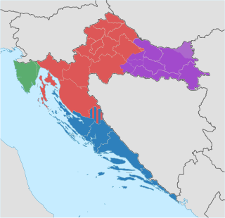
WThe Republic of Croatia is administratively organised into twenty counties, and is also traditionally divided into four historical and cultural regions: Croatia proper, Dalmatia, Slavonia, and Istria. These are further divided into other, smaller regions.
 W
WBanovina, formerly known as Banska krajina or Banija, is a geographical region in central Croatia, between the Sava, Una, and Kupa rivers. The main towns in the region include Petrinja, Glina, Kostajnica, and Dvor. There is no clear geographical border of the region towards the west and the neighboring region of Kordun. The area of Banovina is today administratively almost entirely located within the Sisak-Moslavina County.
 W
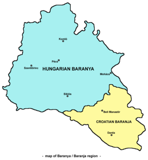
WBaranya or Baranja is a geographical and historical region between the Danube and the Drava rivers. Its territory is divided between Hungary and Croatia. In Hungary, the region is included into Baranya county, while in Croatia, it is included into Osijek-Baranja county.
 W
WBukovica is a geographical region in Croatia. It lies in northern Dalmatia, with Lika to the north, Kninska Krajina to the east, and Ravni Kotari to the southwest.
 W
WCroatia proper is one of the four historical regions of the Republic of Croatia, together with Dalmatia, Slavonia, and Istria. It is located between Slavonia in the east, the Adriatic Sea in the west, and Dalmatia to the south. The region is not officially defined, and its borders and extent are described differently by various sources. In contemporary geography, the terms Central Croatia and Mountainous Croatia are used to describe most of this area, the former referring to the northeastern part and the latter to the southwestern part; the far western part is known as the Croatian Littoral. Croatia proper is the most significant economic area of the country, contributing well over 50% of Croatia's gross domestic product. The capital of the Republic of Croatia, Zagreb, is the largest city and most important economic centre in Croatia proper.
 W
WCvelferija is a geographic region the Croatian part of Syrmia, in eastern Croatia. Villages in the region are Vrbanja, Soljani, Strošinci, Drenovci, Đurići, Račinovci, Gunja, Rajevo Selo, Posavski Podgajci.
 W
WDalmatia is one of the four historical regions of Croatia, alongside Croatia proper, Slavonia, and Istria.
 W
WGorski Kotar is the mountainous region in Croatia between Karlovac and Rijeka. Because 63% of its surface is forested it is popularly called the green lungs of Croatia or Croatian Switzerland. The European route E65, which connects Budapest and Zagreb with the Adriatic Port of Rijeka, passes through the region.
 W
WKninska Krajina is a geographical and historical region in modern-day Croatia, part of the larger Zagora (hinterland) region. It is located around the town of Knin.
 W
WThe Kordun region is a part of central Croatia from the bottom of the Petrova Gora mountain range, which extends along the rivers Korana and Slunjčica, and forms part of the border region to Bosnia and Herzegovina. Within Croatia, Kordun is bordered by the Lika region to the south and by Banovina or Banija to the east. Most of Kordun with its centre Slunj belongs to Karlovac County. Vrginmost belongs to Sisak-Moslavina County. In former times, this region belonged to the Habsburg Military Frontier towards the Ottoman Empire.
 W
WKosinj, also the Kosinj Valley, is a hilly region near Perušić, Croatia, and Lipovo Polje, that contains 2 areas: Upper Kosinj and Lower Kosinj, which are connected by the Kosinj Bridge on the Lika river. Its population is about 1,692, excluding Kosinjski Bakovac.
 W
WKrbava is a historical region located in Mountainous Croatia and a former Catholic bishopric (1185–1460), precursor of the diocese of Modruš an present Latin titular see.
 W
WLika is a traditional region of Croatia proper, roughly bound by the Velebit mountain from the southwest and the Plješevica mountain from the northeast. On the north-west end Lika is bounded by Ogulin-Plaški basin, and on the south-east by the Malovan pass. Today most of the territory of Lika is part of Lika-Senj County. Josipdol, Plaški and Saborsko are part of Karlovac County and Gračac is part of Zadar County.
 W
WMoslavina is a microregion in Croatia, administratively divided into the counties of Zagreb, Sisak-Moslavina and Bjelovar-Bilogora. The main city in the region in terms of traffic, commerce and business is the city of Kutina, with 24,000 citizens. Other important centres are Ivanić-Grad, Čazma, Garešnica and Popovača. Moslavina borders the Zagreb region on the west and the Slavonia region on the east.
 W
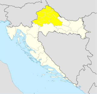
WNorthern Croatia or North Croatia is a region in the northern part of Croatia, which encompasses Varaždin, Međimurje, Zagorje and Koprivnica-Križevci counties, including the cities of Varaždin, Čakovec, Krapina, Koprivnica and Križevci. The Kajkavian dialect is spoken there. It shares borders with Hungary and Slovenia.
 W
WPodravina or Podravje are Slavic names for the Drava river basin in Croatia and Slovenia.
 W
WPosavina is a geographical region that stretches along the Sava river, encompassing only the inner areas of the Sava river basin, that are adjacent or near to the Sava river itself, in Croatia, Bosnia and Herzegovina, and Serbia.
 W
WThe Požega Valley is a geographic microregion of Croatia, located in central Slavonia, encompassing the eastern part of the Požega-Slavonia County. It is located in the Pannonian Basin, bounded by Psunj, Papuk and Krndija mountains from west and north, and Požeška Gora and Dilj from south and east, as the Pannonian plain is interspersed by horst and graben structures. The largest settlement in the region is the city of Požega, followed by Pleternica and Kutjevo. The main watercourse in the region is Orljava River. The region covers 1,249 square kilometres and has a population of 60,599.
 W
WRavni Kotari is a geographical region in Croatia. It lies in northern Dalmatia, around Zadar and east of it. It is bordered by Bukovica to the northeast, lower Krka to the southeast, and the Adriatic Sea. The largest settlement in the region is the town of Benkovac. Other large settlements are Zemunik Donji, Polača, Poličnik, Galovac, Gorica, Škabrnja, Posedarje, Pridraga, Novigrad, and Stankovci.
 W
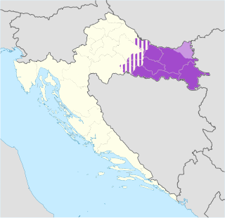
WSlavonia is, with Dalmatia, Croatia proper and Istria, one of the four historical regions of Croatia. Taking up the east of the country, it roughly corresponds with five Croatian counties: Brod-Posavina, Osijek-Baranja, Požega-Slavonia, Virovitica-Podravina and Vukovar-Syrmia, although the territory of the counties includes Baranya, and the definition of the western extent of Slavonia as a region varies. The counties cover 12,556 square kilometres or 22.2% of Croatia, inhabited by 806,192—18.8% of Croatia's population. The largest city in the region is Osijek, followed by Slavonski Brod and Vinkovci.
 W
WSpačva basin is a geographic microregion in Croatia. It is located in the south-western part of Syrmia—the latter being divided by Croatia and Serbia—and the southeastern part of Slavonia macroregion of Croatia, around Spačva river and river Studva. The region's 40.000 hectares of oak forests makes Spačva basin one of the largest continuous lowland oak forests in Europe. In addition, the region forms an organic continuum with the Bosutska šuma literally Bosut Forest in Vojvodina in Serbia. Bosutska šuma is one of two strict nature reserves in Vojvodina. Spačva basin and Bosutska šuma forms the northern section of forest and swampland complex spreding south of Sava river as the Donje Podrinje into Bosnia and Herzegovina and Central Serbia. Wood industry based in Spačva basin is important in the economical life of Vukovar-Srijem County. The major settlement in the region is the town of Otok.
 W
WSyrmia is a region of the southern Pannonian Plain, which lies between the Danube and Sava rivers. It is divided between Serbia and Croatia. Most of the region is flat, with the exception of the low Fruška gora mountain stretching along the Danube in its northern part.
 W
WTuropolje is a region in Croatia situated between the capital city Zagreb and Sisak. The administrative center of the region Turopolje is the town of Velika Gorica.
 W
WHrvatsko zagorje is a cultural region in northern Croatia, traditionally separated from the country's capital Zagreb by the Medvednica Mountain. It comprises the whole area north of Mount Medvednica up to Slovenia in the north and west, and up to the regions of Međimurje and Podravina in the north and east. The population of Zagorje is not recorded as such, as it is administratively divided among Krapina-Zagorje County, and western and central part of Varaždin County. The population of Zagorje can be reasonably estimated to exceed 300,000 people.