 W
WAlto Mira is a settlement in the northwestern part of the island of Santo Antão, Cape Verde. It is situated 4 km southeast of Ribeira da Cruz and 18 km northwest of the island capital Porto Novo. Its population was 1,003 at the 2010 census. The Moroços Natural Park lies east of the settlement. The settlement is divided into several localities, including Chã Bonita, Chã Daurinca, Chã de Dragoeiro, Dominguinhas, Faial and Lombo Gorado. The Ribeira Alto Mira flows through the settlement.
WBolona is a settlement in the westcentral part of the island of Santo Antão, Cape Verde. In 2010 its population was 112. It is situated about 19 km west of the island capital Porto Novo. At about 1,500 m elevation, it is one of the highest settlements of the island.
 W
WCabo da Ribeira is a settlement in the eastern part of the island of Santo Antão, Cape Verde. In 2010 its population was 912. It is situated at about 500 m elevation in the upper valley of the Ribeira do Paul, 5 km southwest of Pombas. It is part of the municipality of Paul, and lies in the Cova-Paul-Ribeira da Torre Natural Park.
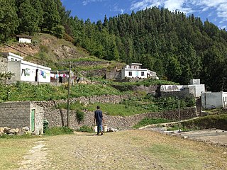
WChã de Pedras is a settlement in the northcentral part of the island of Santo Antão, Cape Verde. In 2010 its population was 1,266. It is situated about 5 km south of Coculi, 8 km southeast of the city Ribeira Grande and 12 km northwest of the island capital Porto Novo. It consists of 21 localities in the valley of the Ribeira de Chã de Pedras, a right tributary of the Ribeira Grande. The elevation of the largest village, Pia de Cima, is about 430 metres.
 W
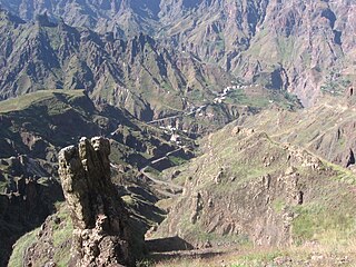
WCorda is a settlement in the island of Santo Antão, Cape Verde. It is part of the municipality Ribeira Grande. It is situated in the mountainous interior of the island at about 1,000 meters elevation, 13 km north of the island capital Porto Novo. Corda consists of several villages, including Chã de Corda and Esponjeiro. The national road from Porto Novo to Ribeira Grande (EN1-SA01) passes through Corda. The crater of Cova lies 4 km to the southeast. Corda lies in the Cova-Paul-Ribeira da Torre Natural Park.
WEito is a village in the northeastern part of the island of Santo Antão, Cape Verde, part of the municipality of Paul. It is situated 1 km southwest of Pombas, 2 km northeast of Figueiral and 15 km northeast of the island capital Porto Novo. Its population was 979 in 2010.
WFigueiral is a settlement in the eastern part of the island of Santo Antão, Cape Verde. In 2010 its population was 591. It is part of the municipality of Paul. It is situated in the valley of the Ribeira do Figueiral, a tributary of the Ribeira do Paul, 2 km southwest of Eito and 3 km southwest of Pombas.
WFigueiras is a settlement in the northern part of the island of Santo Antão, Cape Verde. It is situated in a mountain valley, 20 km northwest of the island capital Porto Novo. The southernmost part lies in Moroços Natural Park.
 W
WFontainhas is a settlement in the northern part of the island of Santo Antão, Cape Verde. It is situated near the rocky north coast of the island, 2 km southwest of Ponta do Sol and 19 km north of the island capital Porto Novo. The settlement includes the smaller villages Corvo and Forminguinhas, about 1 km west of Fontainhas proper.
 W
WGarça de Cima is a settlement in the northern part of the island of Santo Antão, Cape Verde. It is situated in the upper valley of the river Ribeira da Garça, 15 km northwest of the island capital Porto Novo. The southernmost part lies in Moroços Natural Park.
 W
WJanela is a settlement in the eastern part of the island of Santo Antão, Cape Verde. It is situated on the Atlantic coast, 4 km southeast of Pombas and 14 km northeast of the island capital Porto Novo The central village, Pontinha, lies on a rocky peninsula. More villages are situated in the valley of the river Ribeira da Janela. The national road from Porto Novo to Pombas (EN1-SA03) passes through Janela.
WLagoa is a settlement in the central part of the island of Santo Antão, Cape Verde. In 2010 its population was 358. It is situated at about 1,200 m elevation on the eastern plateau of Santo Antão, 11 km northwest of the island capital Porto Novo. The Moroços Natural Park lies about 3 km west of Lagoa.
WLajedo is a settlement in the southcentral part of the island of Santo Antão, Cape Verde. In 2010 its population was 558. It is situated in the valley of Ribeira das Patas, about 11 km west of the island capital Porto Novo. The settlement consists of several localities, including Ponte Sul, Lajedo proper and Vascona. The road from Porto Novo to Ribeira da Cruz in the north of the island passes through Lajedo.
WLombo Branco is a settlement in the northeastern part of the island of Santo Antão, Cape Verde. It is situated 4 km southeast of Ribeira Grande and 17 km north of the island capital Porto Novo.
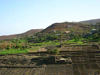
WLombo de Figueira is a settlement in the eastcentral part of the island of Santo Antão, Cape Verde, part of the municipality of Porto Novo and the parish of São João Baptista. In 2010 its population was 281. It is situated about 9 km north of the island capital Porto Novo, on the national road from Porto Novo to Ribeira Grande (EN1-SA01). Subdivisions include Água das Caldeiras and Chã de Tampa. An endemic species of butterflies, Leptotes pirithous capverti, has been found in the area.
WLombo Santa is a settlement in the northern part of the island of Santo Antão, Cape Verde. It is situated in the upper valley of the river Ribeira Grande, 10 km southwest of the town Ribeira Grande and 16 km northwest of the island capital Porto Novo.
WMonte Trigo is the westernmost settlement on the island of Santo Antão, Cape Verde. It is situated on the coast, at the foot of the Tope de Coroa, the highest mountain of the island. It is 28 km west of the island capital Porto Novo. In 2010 its population was 274. About 5 km to the northwest is Ponta do Chão de Mangrade, the westernmost point of all Africa.
WMorro Vento is a settlement in the island of Santo Antão, Cape Verde. It is situated in the mountainous interior of the island, 9 km north of the island capital Porto Novo. The settlement is named after the hill Morro do Vento, elevation 1,409 meters.
 W
WPico da Cruz is a settlement in the northeastern part of the island of Santo Antão, Cape Verde. In 2010 its population was 138. It is situated 6 km southwest of Pombas and 10 km northeast of the island capital Porto Novo. Its elevation is about 1,400 meters. The village is named after the nearby mountain Pico da Cruz. It lies in the Cova-Paul-Ribeira da Torre Natural Park.
WRibeira Alta is a settlement in the northern part of the island of Santo Antão, Cape Verde. It is situated in a mountain valley near the north coast, 19 km northwest of the island capital Porto Novo.
 W
WRibeira da Cruz is a settlement in the northwestern part of the island of Santo Antão, Cape Verde. Situated 22 km northwest of the island capital Porto Novo, it is part of the parish of Santo André, in the municipality of Porto Novo. It had 421 inhabitants at the 2010 census.
WSinagoga is a settlement in the northeastern part of the island of Santo Antão, Cape Verde. It is situated on the coast, 4 kilometers east of Ribeira Grande and 18 km north-northeast of the island capital Porto Novo. It is situated on the national road connecting Ribeira Grande and Pombas (EN1-SA02).
WTarrafal de Monte Trigo is a settlement in the southwestern part of the island of Santo Antão, Cape Verde. In 2010 its population was 841. It is situated on the coast, 27 km west of the island capital Porto Novo. The settlement was mentioned as Terrafal in the 1747 map by Jacques-Nicolas Bellin.
 W
WXoxo is a settlement in the northeastern part of the island of Santo Antão in Cape Verde. It is situated 5 kilometres (3.1 mi) south of Ribeira Grande and 13 kilometres (8.1 mi) north of the island capital Porto Novo. The settlement lies in Cova-Paul-Ribeira da Torre Natural Park. The Ribeira da Torre flows through the settlement. The only road to Xoxo goes from Ribeira Grande through the Ribeira da Torre valley.